Appears in various eds. of Atlas geographicus maior., Includes German text relating to English and French territorial claims., Place names and descriptive notes in English., Prime meridian: Ferro and London., Relief shown pictorially., and Sheet measures 47.5 x 51 cm.
Publisher:
[Homann Erben],
Subject (Geographic):
North America--Maps--Early works to 1800. and United States--History--French and Indian War, 1755-1763--Maps--Early works to 1800.
Subject (Name):
Anville, Jean Baptiste Bourguignon d', 1697-1782. and Homann Erben (Firm). Atlas geographicus maior.
Appears in various eds. of Atlas geographicus maior., Includes German text relating to English and French territorial claims., Place names and descriptive notes in English., Prime meridian: Ferro and London., and Relief shown pictorially.
Publisher:
[s.n.],
Subject (Geographic):
North America--Maps--Early works to 1800. and United States--History--French and Indian War, 1755-1763--Maps--Early works to 1800.
Subject (Name):
Anville, Jean Baptiste Bourguignon d', 1697-1782. and Homann Erben (Firm). Atlas geographicus maior.
Sacrum Imperium Romano-Germanicum oder Teutschland mit seinen angrantzenden Konigreichen und Provincien and Teutschland mit seinen angrantzenden Konigreichen und Provincien
Description:
Backed with paper. Ms. no. "15" in upper right-hand corner. Sheet measures 53.6 x 62.6 cm. No. 15 of 87 maps bound together., Bar scales given in "teutsche Meilen" and "französiche Meilen"., and Prime meridian: Ferro.
Publisher:
[Peter Schenk,
Subject (Geographic):
Europe, Central--Maps--Early works to 1800. and Holy Roman Empire--Maps--Early works to 1800.
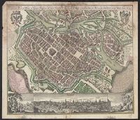
Breslau die uhralte u[nd] hochberühmte Haupt Statt des Herzogth. Schlesien auch vortrefflicher aufenthalt der Musen u[nd] florisanter Handels Plaz an dem Oder Strom and Breslau die uhralte und hochberühmte Haupt Statt des Herzogth. Schlesien auch vortrefflicher aufenthalt der Musen und florisanter Handels Plaz an dem Oder Strom
Description:
"Cum gratia et privil. S.R.I. Vicariat[us] in partib[us] Rheni, Svevice, et Juris Franconici.", Ancillary view: Breslaw. Not drawn to scale., Buildings shown pictorially., Includes index, text, and illustrations., Latin and German., and Sheet measures 56 x 40 cm.
Subject (Geographic):
Wrocław (Poland)--Aerial views--Early works to 1800. and Wrocław (Poland)--Maps--Early works to 1800.
Subject (Name):
Karpinski, Louis Charles,--1878-1956--Ownership., Karpinski-von Wieser Map Collection., and Wieser, Franz,--Ritter von,--1848-1923--Ownership.