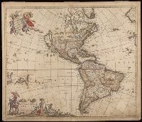
"Cum Privilegio D.D. Ordinum Holl. Westfriliegs.", According to P.D. Burden, Mapping of North America, this is the seventh state of de Wit's map of America, with a new title engraved adding the privilege statement, lower case letters inserted between the latitude numbers and upper case letters between the longitude, and the longitudinal line 338° bearing a bad plate crack in the souther hemipshere, with an erased compass rose at the junction of 338° longitude and 10° north latitude., Appears in various editions of Wit's Atlas., Baked with paper., Number "2" in upper right corner., Prime meridian: Ferro., Relief shown pictorially., and Watermark.
Subject (Geographic):
America--Maps--Early works to 1800. and Western Hemisphere--Maps--Early works to 1800.
"Amstel. cum priv. D.D. Ord. Holl. et West-Fr.", Appears in various editions of Wit's Atlas., Hand colored in outline., Illustrated hand colored title cartouche; sea decorated with ships., Imperfect: chipped and torn, with some loss of text. Backed with paper., Prime meridian: Ferro., and Relief shown pictorially.