Search
You Searched For
Search Results
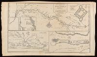
- Creator:
- Hughes, Andrew, 18th century
- Published / Created:
- [1780?]
- Call Number:
- 786 1780A
- Image Count:
- 1
- Resource Type:
- Maps, Atlases & Globes
- Found in:
- Beinecke Rare Book and Manuscript Library > A draught of South Carolina and Georgia from Sewee to St. Estaca / by Andrew Hughes.
- Creator:
- Lodge, John, -1796
- Published / Created:
- [1778?]
- Call Number:
- BrSides 2017 62
- Image Count:
- 1
- Resource Type:
- Maps, Atlases & Globes
- Found in:
- Beinecke Rare Book and Manuscript Library > A general map of North America ; from the latest observations / engrav'd by Jno. Lodge from the late Mr. Jefferys, geographer to the King.
- Creator:
- Anville, Jean Baptiste Bourguignon d', 1697-1782.
- Published / Created:
- [between 1743-1747?]
- Call Number:
- BrSides Folio 2017 16
- Image Count:
- 1
- Resource Type:
- Maps, Atlases & Globes
- Found in:
- Beinecke Rare Book and Manuscript Library > A general map of the River Sanaga, from the falls of Govina to the Ocean / taken by a French Engineer in 1718, & drawn by Sr. d'Anville, from his particular draughts ; G. Child, sculpt.
- Creator:
- Arrowsmith, Aaron, 1750-1823, cartographer.
- Call Number:
- 71 1811
- Image Count:
- 4
- Resource Type:
- Maps, Atlases & Globes
- Found in:
- Beinecke Rare Book and Manuscript Library > A map exhibiting all the new discoveries in the interior parts of North America [cartographic material] / inscribed by permission to the honorable governor and company of the adventurers of England trading into Hudsons Bay, in testimony of their liberal communications to their most obedient and very humble servant A. Arrowsmith, hydrographer to H.R.H. the Prince of Wales, January 1st 1795 ; Puke, sc.
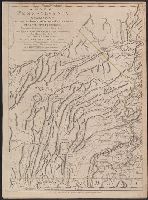
- Creator:
- Scull, William, active 1765, cartographer.
- Published / Created:
- 10 June 1775.
- Call Number:
- 774 1775
- Container / Volume:
- BRBL_00497
- Image Count:
- 2
- Resource Type:
- Maps, Atlases & Globes
- Found in:
- Beinecke Rare Book and Manuscript Library > A map of Pennsylvania exhibiting not only the improved parts of that Province, but also its extensive frontiers: Laid down from actual surveys, and chiefly from the late map of W. Scull published in 1770; and humbly inscribed to the Honorable Thomas Penn
- Creator:
- Scull, William, active 1765, cartographer.
- Published / Created:
- 10 June 1775.
- Call Number:
- 774 1775
- Container / Volume:
- BRBL_00730
- Image Count:
- 3
- Resource Type:
- Maps, Atlases & Globes
- Found in:
- Beinecke Rare Book and Manuscript Library > A map of Pennsylvania exhibiting not only the improved parts of that Province, but also its extensive frontiers: Laid down from actual surveys, and chiefly from the late map of W. Scull published in 1770; and humbly inscribed to the Honorable Thomas Penn
- Creator:
- Madison, James, 1751-1836, creator.
- Published / Created:
- March 4, 1807.
- Call Number:
- BrSides Double Folio 2019 110
- Image Count:
- 1
- Resource Type:
- Maps, Atlases & Globes
- Found in:
- Beinecke Rare Book and Manuscript Library > A map of Virginia [cartographic material] : Formed from actual surveys, and the latest as well as most accurate observations / by James Madison, D.D., president of Wm. & Mary College. ; Drawn by: Wm. Davis. ; Engraved by: Fred. Bossler, Ricmd.
- Creator:
- Phillips, R. (Richard), Sir, 1767-1840
- Published / Created:
- [1806]
- Call Number:
- BrSides Folio 2017 61
- Image Count:
- 1
- Resource Type:
- Maps, Atlases & Globes
- Found in:
- Beinecke Rare Book and Manuscript Library > A map of the country from Rariton River in East Jersey, to Elk Head in Maryland [cartographic material] : shewing the several operations of the American & British armies, in 1776 & 1777 / Neele sc., Strand.
- Creator:
- Rocque, John, -1762.
- Published / Created:
- [between 1762 and 1773]
- Call Number:
- 327 1785
- Image Count:
- 2
- Resource Type:
- Maps, Atlases & Globes
- Found in:
- Beinecke Rare Book and Manuscript Library > A map of the kingdom of Ireland : divided into provinces, counties and baronies, shewing the archbishopricks, bishopricks, cities, boroughs, market towns, villages, barracks, mountains, lakes, bogs, rivers, bridges, ferries, passes : also, the great, the branch and the by post roads, together with the inland navigation, &c. / by John Rocque ...
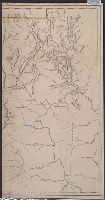
- Creator:
- Jefferys, Thomas, -1771, printmaker.
- Published / Created:
- 1755
- Call Number:
- 783 1755F
- Container / Volume:
- BRBL_00507
- Image Count:
- 1
- Resource Type:
- Maps, Atlases & Globes
- Found in:
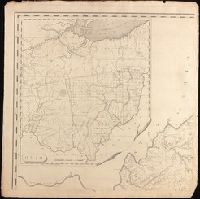
- Beinecke Rare Book and Manuscript Library > A map of the most inhabited part of Virginia containing the whole province of Maryland with part of Pensilvania, New Jersey and North Carolina / drawn by Joshua Fry & Peter Jefferson in 1751.
- Creator:
- Bennett, R. (Richard), creator.
- Published / Created:
- [1765?]
- Call Number:
- 2017 Folio 49
- Image Count:
- 1
- Resource Type:
- Maps, Atlases & Globes
- Found in:
- Beinecke Rare Book and Manuscript Library > A new & accurate map of Germany including the seat of war in the Kingdom of Prussia, Bohemia, Lusatia, Silesia, Saxony, Westphalia &c. : also an exact table of the distances in German & English miles from town to town / by R. Bennett, engraver.
- Creator:
- Bowen, Emanuel, 1693 or 1694-1767, cartographer.
- Published / Created:
- [1747]
- Call Number:
- 655 1747
- Container / Volume:
- BRBL_00345
- Image Count:
- 1
- Resource Type:
- Maps, Atlases & Globes
- Found in:
- Beinecke Rare Book and Manuscript Library > A new & accurate map of Negroland and the adjacent countries : also Upper Guinea, shewing the principal European settlements, & distinguishing w[hi]ch belong to England, Denmark, Holland &c., the sea coast & some of the rivers being drawn from surveys & t
- Creator:
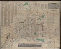
- Silas Farmer & Co.
- Published / Created:
- 1911-12 [i.e. 1911?], and c1911.
- Call Number:
- 811 D48 1911
- Container / Volume:
- BRBL_00553
- Image Count:
- 1
- Resource Type:
- Maps, Atlases & Globes
- Found in:
- Beinecke Rare Book and Manuscript Library > A new map of Detroit and suburbs : includes River Rouge, Oakwood, Highland Park, Hamtramck, St. Clair Heights, and Grosse Pointe.
- Creator:
- Pownall, Thomas, 1722-1805
- Published / Created:
- 12th May 1794.
- Call Number:
- 71 1794P
- Container / Volume:
- BRBL_00726
- Image Count:
- 2
- Resource Type:
- Maps, Atlases & Globes
- Found in:
- Beinecke Rare Book and Manuscript Library > A new map of North America with the West India Islands : divided according to the preliminary articles of peace, signed at Versailles, 20 Jan. 1783, wherein are particularly distinguished the United States, and the several provinces, governments &ca which
- Creator:
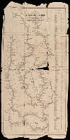
- Munson, Samuel B., 1806-1880.
- Published / Created:
- 1845
- Call Number:
- 80 1845A
- Image Count:
- 1
- Resource Type:
- Maps, Atlases & Globes
- Found in:
- Beinecke Rare Book and Manuscript Library > A new map of the western rivers, or, Travellers guide : exhibiting the Mississippi, Missouri, Ohio, and Illinois rivers with all the principal towns, islands & distances / by Saml. B. Munson.
- Creator:
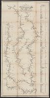
- Munson, Samuel B., 1806-1880, cartographer.
- Published / Created:
- 1844
- Call Number:
- 807 1844
- Image Count:
- 1
- Resource Type:
- Maps, Atlases & Globes
- Found in:
- Beinecke Rare Book and Manuscript Library > A new map of the western rivers, or, Travellers guide : exhibiting the Mississippi, Missouri, Ohio, and Illinois rivers with all the principal towns, islands & distances / by Saml. B. Munson.
- Creator:
- Speed, John, 1552?-1629
- Call Number:
- Lanman 50 1676
- Image Count:
- 2
- Resource Type:
- Maps, Atlases & Globes
- Found in:
- Beinecke Rare Book and Manuscript Library > A newe mape of Tartary / augmented by John Speed and are to be sold by Tho. Bassett in Fleet Street & Richard Chiswell in St. Pauls Churchyard ; Dirck Grÿp, sculp.