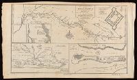
From A new general collection of voyages and travels (London, 1745-47)., In lower left corner: "No. 38.", Numbered: plate IX. Vol. II, p. 45., Relief shown pictorially., Shows River Sanaga, its tributaries, the location and plan of Fort St. Joseph, and the island of Sanaga., and Watermark.
Publisher:
Labat,
Subject (Geographic):
Cameroon--Maps--Early works to 1800. and River Sanaga (Cameroon)--Maps--Early works to 1800.
Subject (Name):
Child, G., engraver. and Labat, Jean Baptiste, 1663-1738, publisher.
New and accurate map of Negroland and the adjacent countries
Description:
Includes decorative title cartouche with figures., Prime meridian: London, Relief shown pictorially., Shows boundaries, rivers, and principal settlements, with tents showing areas inhabited by nomads., and Watermark.
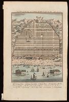
Bird's-eye view of Canton, now Guangzou, China; relief shown pictorially., From: Navigantium atque itinerantium bibliotheca ... / John Harris. -- London : T. Woodward, 1744-1748., In upper right-hand corner: Vol. 1. pa. 359., and Indexed for points on interest.
Publisher:
[T. Woodward],
Subject (Geographic):
Guangzhou (China)--Maps--Early works to 1800.
Subject (Name):
Harris, John, 1667?-1719. Navigantium atque itinerantium bibliotheca.
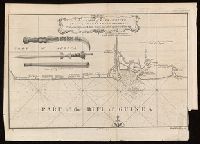
Coordinates not present on map and are approximated., From A new general collection of voyages and travels (London, 1745-47)., Includes illustrations of "weapons used by the Hakbous blacks.", Lower left: "No. 87.", Lower right: "Plate X, Vol. III, p. 105.", and Stamps: Glasgow Public Libraries.
Publisher:
[publisher not identified],
Subject (Geographic):
Cross River State (Nigeria)--Maps--Early works to 1800.
Subject (Name):
Child, G., engraver. and Glasgow (Scotland). Public Libraries Stamp.
Subject (Topic):
Coasts--Nigeria--Calabar Province--Maps--Early works to 1800.
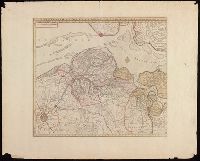
Concentric rings at one mile intervals from Huntingdon., Dedicated to the Robert Montagu, Duke of Manchester., Imperfect: edges trimmed, with loss of imprint information. Dissected and mounted on linen. In cover with label "17 Huntingdonshire.", Notes about the county; includes "Index Villaris.", Prime meridian: London., Relief shown by hachures., and Shows boundaries, roads, woods, parks and settlements.
Publisher:
[Emanuel Bowen?],
Subject (Geographic):
Huntingdonshire (England)--Early works to 1800--Maps.
Subject (Name):
Bowles, John, 1701-1779, publisher. and Hinton, John, -1781, bookseller.
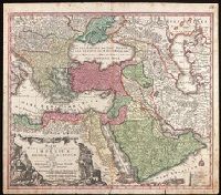
Includes three bar scales., Prime meridian: Ferro., Relief shown pictorially., and Watermark. Manuscript number in upper right corner: 94. From the Karpinski Collection.
Publisher:
[Mattheus Seutter],
Subject (Geographic):
Middle East--Maps--Early works to 1800.
Subject (Name):
Drentwet, Abraham, -1785, engraver. and Karpinski, Louis Charles,--1878-1956--Ownership.