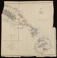
Coastal chart., Imperfect: Mutilated with loss of information., Includes text: "Instructions for the coast of South Carolina, Georgia, and the coast of St. Augustin"., and Oriented with north to the left.
Publisher:
W. Mount and T. Page,
Subject (Geographic):
Atlantic Coast (South Atlantic States)--Maps., Georgia--Maps--Early works to 1800., and South Carolina--Maps--Early works to 1800.
Subject (Topic):
Coastwise navigation--Atlantic Coast (South Atlantic States)
Includes brief notes on the Irish history and political divisions., Inset: The sea coasts of Great Britain and Ireland. Scale approximately 1:4,500,000., Originally printed on 4 sheets., Relief shown pictorially., Robert Sayer traded alone & at this address 1751-1774 and 1783-1792 (cf. Maxted, p. l99)., Shows boundaries, rivers, lochs, roads with distances, woods and settlements., and Title cartouche depicts engraved stone, cow, and reclining figure holding a peat spade.
Publisher:
Printed for Robt. Sayer, opposite Fetter Lane, Fleet Street,
Inset: The sea coasts of Great Britain and Ireland. Scale approximately 1:4,500,000., Originally printed on 4 sheets., Relief shown pictorially., Robert Sayer traded alone & at this address 1751-1774 and 1783-1792 (cf. Maxted, p. l99)., Shows boundaries, rivers, lochs, roads with distances, woods and settlements., and Title cartouche depicts engraved stone, cow, and reclining figure holding a peat spade.
Publisher:
Printed for Robt. Sayer, opposite Fetter Lane, Fleet Street,
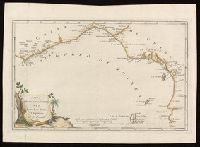
"European Magazine" in upper right., Coordinates not present on map and are approximated., Imperfect: left portion of map and upper right portion of map wanting, with some loss of text., Relief shown pictorially., and Watermark.
Publisher:
Published April 1, 1782, by I. Fielding, Pater noster Row, J. Sewell, Cornhill, and J. Debrett, Piccadilly,
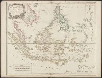
Covers present-day Indonesia, the Philippines, Malayan peninsula, Indo-Chinese peninsula, and north-west coast of Australia., From: Atlas universel / par m. Robert geographe et Robert de Vaugondy son fils. Paris, 1757-[1786]., Includes inset map., and Inset: Isl
Publisher:
[publisher not identified],
Subject (Geographic):
Asia--East Indies, Australia--Maps--Early works to 1800., East Indies--Maps--Early works to 1800., Mariana Islands--Maps--Early works to 1800., and Southeast Asia--Maps--Early works to 1800.
Subject (Name):
Haye, G. de la, engraver. and Robert de Vaugondy, Gilles, 1688-1766. Atlas universel.