Plaisirs de l’isle enchantee, ou, Les festes, et divertissements du roy, a Versailles, Festes, et diuertissements du roy, a Versailles, and Plaisirs de l’isle enchantee
Description:
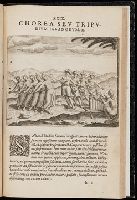
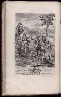
1 unnumbered plate by Francois Chauveau, representing entertainments held in 1674 on the termination of the campaign in Franche-Comte., 5 plates, numbered I-V, by Jean Le Pautre, representing the festivities at Versailles on July 18, 1668., 5 unnumbered plates by Jean Le Pautre., Armorial bookplate with motto: Ubique patriam reminisci., Binding with French royal arms (Bourbon)., Nine plates, numbered 1-9, by Israel Silvestre., On spine: Tom. XI., The first series of 9 plates was originally published in 1673 under the title: Les plaisirs de l’isle enchantee ..., The next series of 5 plates was originally published in 1679 under the title: Relation de la feste de Versailles, du 18e juillet mil six cens soixante-huit., The third series of 6 plates was originally published in 1676 under the title: Les divertissemens de Versailles donnez par la roy a toute sa cour, au retour de la conqueste de la Franche-Comte, en l’annee M.DC.LXXIV ..., The three sequences of plates were each originally published separately with text by Andre Felibien., and Two plates have Yale proprietary stamps on verso; all other versos blank.
Subject (Geographic):
France --Court and courtiers --Pictorial works
and France --History --Louis XIV, 1643-1715
Subject (Name):
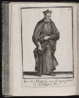
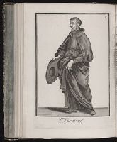
Chauveau, Francois, 1613-1676, Felibien, Andre, sieur des Avaux et de Javercy, 1619-1695. Divertissemens de Versailles donnez par le roy a toute sa cour au retour de la conqueste de la Franche-Comte en l’annee M.DC.LXXIV, Felibien, Andre, sieur des Avaux et de Javercy, 1619-1695. Plaisirs de l’isle enchantee, Felibien, Andre, sieur des Avaux et de Javercy, 1619-1695. Relation de la feste de Versailles du dix-huitieme juillet mil six cents soixante-huit, Le Pautre, Jean, 1618-1682, and Silvestre, Israel, 1621-1691
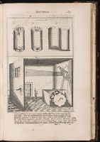
Various illustrations by Maria Sibylla Merian and others[?] employing alchemical symbols and icons.
Description:
Added t.p.; title within engraved border., Folded plate: Figura I measures 34 x 33 cm., Folded plate: Figura II measures 39 x 31 cm., Folded plate: Figura III measures 35 x 35 cm., Folded plate: Figura IV measures 35 x 39 cm., and Many of the tracts have special t.ps. dated 1677.
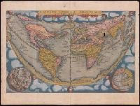
Speculum geographicum totivs Germaniae repraesentans. and Speculum orbis terrarum
Description:
Foliation: 2 unnumbered bifolia, XXVII bifolia, 1 bifolium, XXXVIII bifolia, 1 unnumbered bifolium., Imperfect: wormed, with no loss of text; holes in map "Universi orbis seu terreni globi ..." Misbound: gatherings x-y bound after gathering z. No. 148 in H. C. Taylor coll., Imprint from colophon., Ninety maps on 65 sheets; text on verso of maps., Part 2 has title: Speculum geographicum totius Germaniae Imperium repraesentans., Signatures: pi² 2pi² a-c² [superscript chi]c² d-s² v-z² [superscript chi]Z² 2a-2c² [2d]², [superscript chi]A² A-2P² [2Q]² (2Q2 blank; signatures [superscript chi]A and A are signed 'A2')., and With dedication on verso of title page, dated 1578.
Publisher:
de Catelyne Vesten, ad intersigne Floreni aurati, in aedibus Gerardi de Iode, typis Gerardi Smits,
First ed., 2nd issue. Cf. Church., From t.p.: qua continentur I. Secunda pars nauigationum à Ioanne Hugone Lintschotano in Orientem susceptarum & maximè situs illarum regionum, & in his insularum, fluminum, riparum, portuum, &c. tum in transitu, tum ipsa India sitorum : vbi iuxta etiam vniuersa, quae autor illic, & postea in reditu versus Hollandiam vidit & notauit, diligenter designanter -- II. Nauigatio Hollandorum in insulas Orientales, Iauan & Sumatram, vbi pariter de moribus, vita, & religione incolarum quaedam haud iniucunda traduntur -- III. Tres nauigationes Hollandorum in modò dictum Indiam per Septentrionalem seu glacialem Oceanum, vbi mira quaedam & stupenda denarrantur., Imperfect: plate XXXII and 1 map wanting (Deliniatio cartae trium navigationum per Batavos ad Septentrionalem); q4 blank, wanting; wormed throughout, with loss of text. Some text redacted. The maps issued with this part, and a map and plate issued with part two, are bound before part 2 in the following order: [1] A cidade de Angra ... (40 x 55 cm. on sheet 41 x 57 cm, folded to 30 x 15); [2] Descriptio Hydrograhica accomodata ad Battavorum navagatione in Javam isulam Indiae Orientalis... (34 x 65 cm, on sheet 36 x 65 cm, folded to 29 x 18 cm); [3] Insula D. Helenae ... (22 x 28 cm, on sheet 30 x 31); [4] Munken so in den Orientalischen Indien ... (14 x 18 cm, on sheet 19 x 30 cm) bound with top of sheet at gutter; [5] Vera effigies et delineatio Insulae Ascenstio ... (15 x 22 cm, on sheet 19 x 30 cm) bound with top of sheet at gutter; [6] Insulae et arcis Mocambique ...(21 x 27 cm, on sheet 31 x 30 cm). No. 3 of 3 titles bound together., Leaf XXXII consists of 2 leaves ; five unnumbered maps are on [10] leaves; one unnumbered map is on [1] leaf., Maps: [1] Insula D. Helenae sacra ... [1601]. Scale not given. [2] Vera effigies et delineatio Insulae Ascenstio nuncupate ... [1601]. Scale not given. [3 (on two sheets)] Descriptio Hydrograhica accomodata ad Battavorum navagatione in Javam isulam Indiae Orientalis ... [1601]. Scale [ca. 1:25,000,000]. [4] A cidade de Angra ... [1601]. Scale not given. [5] Deliniatio cartae trium navigationum per Batavos ad Septentrionalem plaggem Norvegia, Moscovia et Novae Zembla ... autore Wilhelmo Bernardo ... [1601]. Scale [ca. 1:15,000,000]., Pt. I contains chapters 92-99 of Linschoten's Itinerario; pt. II is the 1st pt. of Willem Lodewijcksz' account of a voyage made to the East Indies in 1595-97., and Signatures: *⁴ A-X⁴ Y⁶ a-h⁴ i² k-q⁴ (*4,Y6, q4 blank).
Publisher:
Excudebat Matthaeus Beckerus,
Subject (Geographic):
East Indies--Description and travel--Early works to 1800. and East Indies--Discovery and exploration--Early works to 1800.
Subject (Name):
Becker, Matthias, fl. 1573-1606, publisher., Bry, Johann Israel de, -1611, printer., Bry, Johann Theodor de, 1561-1623?, printer., Linschoten, Jan Huygen van, 1563-1611. Secunda pars nauigationum., Lodewycksz, Willem, active 16th century. Navigatio Hollandorum in insulas Orientales., and Veer, Gerrit de. Tres navigationes Hollandorum.