Skip to search
Skip to main content
Skip to first result
Yale University Library
Ask Yale Library
Reserve Rooms
Places to Study
Research
Quicksearch
Search Library Catalog (Orbis)
Search Law Library Catalog (MORRIS)
Search Borrow Direct
Search WorldCat
Search Articles+
Search Digital Collections
Search Archives at Yale
Research Guides
Find Databases by Title
Find eJournals by Title
Guide to Using Special Collections
Services
Your Personal Librarian
Subject Specialists
Research Support and Workshops
Citation Tools
OverDrive: Popular Audio and eBooks
Get It @ Yale (Borrow Direct, Interlibrary Loan, Scan & Deliver)
Course Reserves
Off-Campus Access
EliScholar
OverDrive: Popular Audio and eBooks
Bass Media Equipment
Libraries & Collections
Arts Library
Bass Library
Beinecke Library
Classics Library
Divinity Library
Film Study Center
Fortunoff Archive
Humanities Collections
International Collections
Law Library
Lewis Walpole Library
Library Collection Services
Manuscripts & Archives
Map Collection
Marx Science & Social Science Library
Medical Library
Music Library
Sterling Library
Yale Center for British Art
Information & Policies
Library Hours
Departments & Staff
Borrowing & Circulation
Services for Persons with Disabilities
Copyright Basics
Scanning, Printing & Copying
Computers & Wireless
Library Policies
About the Library
Giving to the Library
Purchase Request
Working at the Library
Terms Governing Use of Materials
Search in
All Fields
Creator
Title
Call Number
Date
Subject
Orbis ID
Full Text
Description
Full text
search for
Search
Search
Advanced Search
Digital Collections
Search
You Searched For
Genre
Prints (Visual works)
Resource Type
Maps, Atlases & Globes
New Search
« Previous
|
1
-
30
of
115
|
Next »
Sort
by Creator (Z --> A)
relevance
Creator (A --> Z)
Creator (Z --> A)
Title (A --> Z)
Title (Z --> A)
Year (ascending)
Year (descending)
Number of results to display per page
30
per page
9
per page
30
per page
60
per page
99
per page
View results as:
List
List
Gallery
Gallery
Search Results
Map of the United Kingdom of Great Britain and Ireland
The phenomena of the universe ...
A new universal atlas containing maps of the various empires, kingdoms, states and republics of the
Befchryving van het Eyland Madagascar en deszelfs Canaal ...
De Oostin-dische zee / Het Eyland Mayota
Des rivier legt op de Hoogte von 18 Graaden Zuyder Breedte aan het Land van de Megosie ter Kuste
Madagascar
A general map of the middle British colonies in America
A contracted scetch of the plan of London &c. : printed on 24 sheets of imperial paper, to shew the
A new general chart of the West Indies from the latest marine journals and surveys. Regulated and
Atlas francois ...
La Generalite de Paris divisee ens ses eslections
Leogane and Port au Prince in the island of Hispaniola. pl. 33
Plan of the city and harbour of Havanna. pl. 23
Les Etats de Savoye et de Piemont
A map of Lewis and Clark's track, across the western portion of North America fom the Mississippi
Looking up the Toroweap from Vulcan's Throne
Panorama from Point Sublime
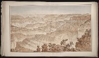
Panorama from Point Sublime
Panorama from Point Sublime
An authentic plan of the town and harbour of Cap Francois in the isle of St. Domingo. By Thomas
Jamaica from the latest surveys; improved and engraved by Thomas Jefferys geographer to the king
South part of St. Domingo, of Hispaniola, by Thos Jeffreys geographer to his Majesty
The harbour of Bluefields.
The island of Hispaniola called by the French St. Domingo. Subject to France and Spain. from the
Turks Islands, from a survey made in 1753, by the the sloops l'Aigle and l'Emeraude, by order of
Comte de Namur dresse sur les memoirs les plus nouveaux presente a sa Majeste pour le service de
Lengths of the principal rivers in the world
Plan of the cities of London and Westminster, the Borough of Southwark, and parts adjoining
Carte de nouvelles decouvertes au nord de la mer du Sud, tant a lest de la Siberie et du Kamtchatka
PREVIOUS
«
1
2
3
4
»
NEXT
Limit your search
Extent of Digitization
Partially digitized
110
Unspecified
3
Completely digitized
2
Access
Public
114
Yale Community Only
1
Repository
Beinecke Rare Book and Manuscript Library
115
Format
cartographic
88
still image
21
mixed material
5
text
1
Genre
Prints (Visual works)
✖
[remove]
115
Maps
94
Engravings
90
Illustrations
48
Maps in books
45
Hand coloring
7
Title pages
5
Atlases
4
Etchings
4
Lithographs
4
more
Genre
»
Resource Type
Maps, Atlases & Globes
✖
[remove]
115
Language
English
13
Italian
2
Creator
Jefferys, Thomas, d. 1771
6
Julius Bien & Co. lith
4
Keulen, Gerard van
4
Keulen, Johannes van.
4
Marre, Jan de, 1696-1763.
4
Vooght, Claes Janszoon, d. 1696.
4
Clark, William, 1770-1838
3
Fee, Chas E
2
Robert Sayer and John Bennett (Firm)
2
Sanson, Nicolas, 1600-1667
2
more
Creator
»
Subject (Topic)
Geography--Early works to 1800
10
Geography--Pictorial works
10
Atlases--Early works to 1800
9
Islands
8
Nautical charts
8
Voyages and travels
8
Discoveries in geography
5
Explorers
5
Geography, Ancient
5
Scientific expeditions
5
more
Subject (Topic)
»
Subject (Name)
Elmina Castle (Elmina, Ghana)
3
Nicholas, Edward, d. 1726 --Bookplate and Autograph
2
P.S. Duval & Son
2
Hodgson, Ralph,--1871-1962--Autograph
1
Publication Place
Chicago
2
Berlin, Paris
1
Mexico, Berlin
1
New York
1
Paris
1
Philadelphia
1
Veracruz
1
[London]
1
[London] :
1
Date Created
View distribution
Current results range from
1691
to
1891
Date Created range begin
Date Created range end
View larger »
[Missing]
72