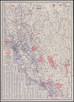
Texaco touring map of California, Nevada. and Texaco touring map of Washington, Oregon.
Description:
"3-4400-27.", "3-4432-29.", "Copyright by Rand McNally & Company.", Date based on gasoline tax table dated Jan. 1954., Includes indexes., Panel title., Relief shown pictorially and by spot heights., and Texaco touring map of Washington, Oregon -- Texaco touring map of California, Nevada.
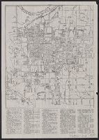
Also shows streetcar routes., Indexed., Ms notes in ink to indicate "historic annexations.", and Oriented with north toward the upper right.
Publisher:
H.W. Gross,
Subject (Geographic):
Saint Louis (Mo.)--Maps and Saint Louis Metropolitan Area (Mo.)--Maps
Subject (Topic):
Roads--Missouri--Saint Louis Metropolitan Area--Maps, Street-railroads--Missouri--Saint Louis Metropolitan Area--Maps, Street-railroads--Missouri--Saint Louis--Maps, and Streets--Missouri--Saint Louis--Maps
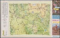
"Issued for free distribution only by Wyoming State Highway Commission and Wyoming Tourist Bureau.", In lower right: 5-4617-8., Includes indexes, ill., and text., Map of "Western United States," col. photos, distance table, and text on verso., and Relief shown by shading and spot heights.
Publisher:
Wyoming State Highway Commission? : and Wyoming Tourist Bureau?,
Subject (Geographic):
Wyoming--Maps
Subject (Name):
Wyoming Tourist Bureau, Wyoming. State Highway Commission, and Wyoming. State Highway Dept