Skip to search
Skip to main content
Skip to first result
Search
You Searched For
Genre
Thematic maps
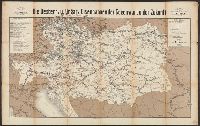
Search Results
Creator:
Published / Created:
1872
Call Number:
41gme 1872
Container / Volume:
BRBL_00243
Image Count:
2
Resource Type:
Maps, Atlases & Globes
Alternative Title:
Oesterreich. & Ungarischen Eisenbahnen der Gegenwart und der Zukunft
Publisher:
Eigenthum und Verlag von Artaria & Co.,
Subject (Name):
Köke, F
Subject (Topic):
Railroads--Austria--Maps and Railroads--Hungary--Maps
Found in:
Beinecke Rare Book and Manuscript Library > Die Oesterr. u. Ungar. Eisenbahnen der Gegenwart u. der Zukunft : Karte zur Übersicht aller befahrenen u. projectirten Eisenbahnen mit genauer Unterscheidung der Gesellschaften : Karte zur Reise mit genauer Angabe aller Eisenbahn-Stationen im Anschlusse
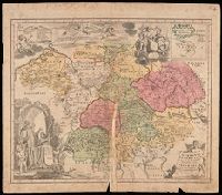
Creator:
Published / Created:
a MDCCXXXII [1732]
Call Number:
BrSides Double Folio 2019 49
Image Count:
1
Resource Type:
Maps, Atlases & Globes
Description:
Imperfect: mutilated along fold, with some loss of text; chipped. Manuscript number in upper right corner: 4. From the Karpinski-von Wieser Map Collection.
Publisher:
[Homann Erben]
Subject (Geographic):
Europe, Central and Germany
Subject (Topic):
Benedictine monasteries--Europe, Central--Maps--Early works to 1800, Benedictine monasteries--Germany--Maps--Early works to 1800, Monasteries--Europe, Central--Maps--Early works to 1800, and Monasteries--Germany--Maps--Early w
Found in:
Beinecke Rare Book and Manuscript Library > Germania Benedictina quae in illa sunt monasteria Ord. S. Benedicti monstrans. exacte ita delineata per P.R.C.P.W.C.B.S. / excusa studio et sumtibus Homannianorum Heredum.
Creator:
Published / Created:
[1943]
Call Number:
49 1943A
Container / Volume:
BRBL_00268
Image Count:
1
Resource Type:
Maps, Atlases & Globes
Description:
"Behelfsmässige Ausgabe"--Upper margin.
Publisher:
[Generalstab des Heeres, Abteilung für Kriegskarten- und Vermessungswesen],
Subject (Topic):
Railroads--Africa, North--Maps, Railroads--Greece--Maps, Railroads--Italy--Maps, and Railroads--Italy--Sicily--Maps
Found in:
Beinecke Rare Book and Manuscript Library > Griechenland-Tunis, Eisenbahnkarte 1:2 500 000.
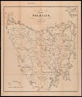
Creator:
Published / Created:
[between 1860 and 1880]
Call Number:
266 1860
Image Count:
1
Resource Type:
Maps, Atlases & Globes
Alternative Title:
H.G. de Gruchy and Cos. new map of Tasmania and New map of Tasmania
Description:
Map of Tasmania showing counties, towns, roads and post offices with relief shown by hachures and spot heights.
Publisher:
H.G. de Gruchy & Cos,
Subject (Geographic):
Tasmania--Administrative and political divisions--Maps. and Tasmania--Maps.
Subject (Topic):
Counties--Australia--Tasmania--Maps.
Found in:
Beinecke Rare Book and Manuscript Library > H.G. de Gruchy & Cos. new map of Tasmania / lithographed & published at their Colonial Map Depot.
Creator:
Published / Created:
[1918]
Call Number:
11hcf 1919-47
Image Count:
1
Resource Type:
cartographic image
Description:
BEIN 11hcf 1919-47: Sheets pasted together and backed with paper. Manuscript note in upper left corner: Unrevisied. Manuscript number in lower left corner: 6-19. Manuscript markings on map.
Publisher:
American Geographical Society of New York
Subject (Geographic):
Hungary and Hungary.
Subject (Topic):
Ethnology
Found in:
Beinecke Rare Book and Manuscript Library > Hungary, nationalities
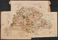
Creator:
Published / Created:
[1918]
Call Number:
11hcf 1919-45
Image Count:
1
Resource Type:
cartographic image
Description:
BEIN 11hcf 1919-45: Sheets pasted together and backed with paper. Manuscript note in upper left corner: Unrevisied. Manuscript number in lower left corner: 6-210.
Publisher:
American Geographical Society of New York
Subject (Geographic):
Hungary and Hungary.
Subject (Topic):
Population density
Found in:
Beinecke Rare Book and Manuscript Library > Hungary, population density
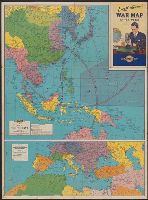
Creator:
Published / Created:
[1942]
Call Number:
556 1941B
Container / Volume:
BRBL_00293
Image Count:
2
Resource Type:
Maps, Atlases & Globes
Alternative Title:
Map of Southern Europe, the Mediterranean area and the Near East., Map of the Far East., War map of Atlantic Ocean area, Eurasia and Africa., War map of Pacific Ocean and the Far East., and War map of the world
Description:
Includes notes, inset of "World time zones," and col. ill.
Publisher:
Rand McNally & Co.,
Subject (Name):
Thomas, Lowell, 1892-1981
Subject (Topic):
Time--Systems and standards--Maps and World War, 1939-1945--Maps
Found in:
Beinecke Rare Book and Manuscript Library > Lowell Thomas' war map of the world [cartographic material] : [compliments of] Sunoco.
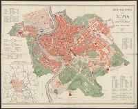
Published / Created:
1885
Call Number:
40 R66 1885
Container / Volume:
BRBL_00219
Image Count:
1
Resource Type:
Maps, Atlases & Globes
Description:
Includes index.
Publisher:
Libreria editrice ditta Perino di Cerroni e Solaro,
Subject (Geographic):
Rome (Italy)--Maps
Subject (Topic):
City planning--Italy--Rome--Maps
Found in:
Beinecke Rare Book and Manuscript Library > Pianta della città di Roma : colle più recenti aggiunte e varianti al piano regolatore.
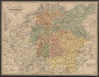
Creator:
Published / Created:
1856
Call Number:
36gmd 1856B
Container / Volume:
BRBL_00131
Image Count:
1
Resource Type:
Maps, Atlases & Globes
Description:
This map differs slightly from that of an earlier edition Covers 36gmd 1854.
Publisher:
s.n],
Subject (Geographic):
Europe, Central--Maps and Germany--Maps
Subject (Topic):
Postal service--Germany--History, Transportation--Europe, Central--Maps., and Transportation--Germany--Maps.
Found in:
Beinecke Rare Book and Manuscript Library > Post-und Reise-Karte von Deutschland [cartographic material] : und einem Theile der angrenzenden Länder nach den besten Hilfsmitteln neu bearbeitet.