Search
You Searched For
Search Results
- Creator:
- Geological Survey (U.S.)
- Published / Created:
- 1912
- Call Number:
- 848 G95 1912
- Container / Volume:
- BRBL_00632
- Image Count:
- 1
- Resource Type:
- Maps, Atlases & Globes
- Found in:
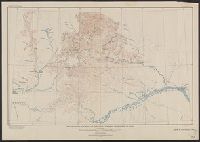
- Beinecke Rare Book and Manuscript Library > Geologic reconnaissance map of headwater region of Gulkana and Susitna Rivers, Alaska / U.S. Geological Survey. Alfred H. Brooks, geologist in charge of division, topography and triangulation by D.C. Witherspoon, C.E. Giffin and J.W. Bagley.
- Creator:
- Geological Survey (U.S.)
- Published / Created:
- [1918]
- Call Number:
- 848 J953 1918
- Container / Volume:
- BRBL_00633
- Image Count:
- 1
- Resource Type:
- Maps, Atlases & Globes
- Found in:
- Beinecke Rare Book and Manuscript Library > Juneau and vicinity, Alaska / Alfred H. Brooks, geologist in charge of division ; topography by D.C. Witherspoon.
- Creator:
- Geological Survey (U.S.)
- Published / Created:
- 1913
- Call Number:
- 848 K842 1913
- Container / Volume:
- BRBL_00633
- Image Count:
- 1
- Resource Type:
- Maps, Atlases & Globes
- Found in:
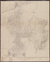
- Beinecke Rare Book and Manuscript Library > Reconnaissance map of Koyukuk-Chandalar region, Alaska / U.S. Geological Survey ; Alfred H. Brooks, Geologist in charge of division, topography and triangulation by T.G. Gerdine ... [et al.].
- Creator:
- Geological Survey (U.S.)
- Published / Created:
- 1921
- Call Number:
- 848 R82 1921
- Container / Volume:
- BRBL_00634
- Image Count:
- 1
- Resource Type:
- Maps, Atlases & Globes
- Found in:
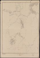
- Beinecke Rare Book and Manuscript Library > Reconnaissance map of Ruby district, Alaska / U.S. Geoogical Survey; Alfred H. Brooks, geologist in charge of division.
- Creator:
- Geological Survey (U.S.)
- Published / Created:
- 1907
- Call Number:
- 848 Se87 1907
- Container / Volume:
- BRBL_00634
- Image Count:
- 1
- Resource Type:
- Maps, Atlases & Globes
- Found in:
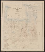
- Beinecke Rare Book and Manuscript Library > Reconnaissance map of northeastern portion of Seward Peninsula Alaska / U.S. Geological Survey ; Alfred H. Brooks, geologist in charge ; D.C. Witherspoon, topographer ; C.E. Hill, field assistant.
- Creator:
- Geological Survey (U.S.)
- Published / Created:
- 1921
- Call Number:
- 848 K96 1921
- Container / Volume:
- BRBL_00633
- Image Count:
- 1
- Resource Type:
- Maps, Atlases & Globes
- Found in:
- Beinecke Rare Book and Manuscript Library > Reconnaissance map of the Lower Kuskokwim region, Alaska / U.S. Geological Survey ; Alfred H. Brooks, Geologist in charge of division, topography by A.G. Maddren, R.H. Sargent and W.S. Post.
- Creator:
- Geological Survey (U.S.)
- Published / Created:
- 1922
- Call Number:
- 848 In5 1922
- Container / Volume:
- BRBL_00633
- Image Count:
- 1
- Resource Type:
- Maps, Atlases & Globes
- Found in:
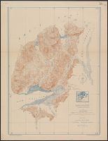
- Beinecke Rare Book and Manuscript Library > Topographic map of Iniskin-Chinitna Peninsula, Cook Inlet region, Alaska / United States Department of the Interior Geological Survey ; Alfred H. Brooks, geologist in charge of division ; topography by C.P. McKinley and Gerald Fitz-Gerald.
- Creator:
- Geological Survey (U.S.)
- Published / Created:
- 1922
- Call Number:
- 848 T15 1922
- Container / Volume:
- BRBL_00634
- Image Count:
- 1
- Resource Type:
- Maps, Atlases & Globes
- Found in:
- Beinecke Rare Book and Manuscript Library > Topographic reconnaissance map of Upper Tanana River Valley region, Alaska / U.S. Geological Survey; Alfred H. Brooks in charge of division; Control and topography by D.C. Witherspoon and J.W. Bagley; Upper Tanana River from boat traverses by W.J. Peters.