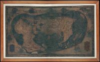
Columbus, Christopher Hammer, Heinrich, active 1480-1496, cartographer Rosselli, Francesco di Lorenzo, 1445-1513
Published / Created:
ca. 1489
Call Number:
Art Storage 1980 157
Image Count:
3
Description:
"Opus [fecit?] Henricus Martellus Germanus.", Devised devised by cataloger., Map is drawn on "pseudo-cordiform" projection., Mounted on canvas. An engraved border is pasted on canvas around the map., Represents the whole of the Old World (Europe, Africa, Asia)., and Twelve windheads, with short descriptive legends in scrolls, and conventional cloud symbols surround map; includes two longer legends in panels in bottom corners.