Search
You Searched For
Search Results
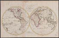
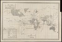
- Published / Created:
- [1795?]
- Call Number:
- 11 1795A
- Container / Volume:
- BRBL_00006
- Image Count:
- 1
- Resource Type:
- Maps, Atlases & Globes
- Found in:
- Beinecke Rare Book and Manuscript Library > A Chart of the World, According to Mercator's Projection, showing the latest discoveries of Capt. Cook.
- Published / Created:
- 1795
- Call Number:
- 11 1795
- Container / Volume:
- BRBL_00006
- Image Count:
- 1
- Resource Type:
- Maps, Atlases & Globes
- Found in:
- Beinecke Rare Book and Manuscript Library > A Map of the World from the best Authorities.
- Creator:
- Adam and Charles Black (Firm)
Aikman, George, engraver
Barlow, Peter, 1776-1862
- Published / Created:
- 1854]
- Call Number:
- 11 1854
- Container / Volume:
- BRBL_00009
- Image Count:
- 1
- Resource Type:
- Maps, Atlases & Globes
- Found in:
- Beinecke Rare Book and Manuscript Library > A chart of magnetic curves of equal variation / by Peter Barlow.
- Creator:
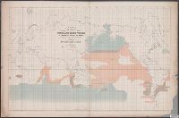
- Maury, Matthew Fontaine, 1806-1873
- Published / Created:
- 1853
- Call Number:
- 11DB 1851A-2
- Container / Volume:
- BRBL_00774
- Image Count:
- 1
- Resource Type:
- Maps, Atlases & Globes
- Found in:
- Beinecke Rare Book and Manuscript Library > A chart showing the favorite resort of the sperm and right whale [cartographic material] / by M.F. Maury L.L.D. Lieut. U.S. Navy ; constructed from Maury's whale chart of the world by Robt. H. Wyman Lieut. U.S.N.
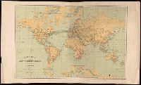
- Creator:
- Great Britain. War Office. General Staff. Geographical Section
- Published / Created:
- 1909
- Call Number:
- BrSides Double Folio 2018 95
- Image Count:
- 1
- Resource Type:
- Maps, Atlases & Globes
- Found in:
- Beinecke Rare Book and Manuscript Library > Cable map of the world [cartographic material].
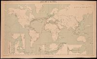
- Creator:
- International Telecommunication Union. Bureau
- Published / Created:
- 1896
- Call Number:
- BrSides Folio 2018 130
- Image Count:
- 1
- Resource Type:
- Maps, Atlases & Globes
- Found in:
- Beinecke Rare Book and Manuscript Library > Carte générale des grandes communications télégraphiques du monde / dressée d'après des documents officiels par le Bureau International des Administrations Télégraphiques ; dessinée et gravée par C. v. Hoven.
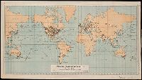
- Creator:
- United States. Department of the Treasury. Bureau of Statistics
- Published / Created:
- [1900]
- Call Number:
- BrSides Double Folio 2019 2
- Image Count:
- 1
- Resource Type:
- Maps, Atlases & Globes
- Found in:
- Beinecke Rare Book and Manuscript Library > Colonial systems of the world / U.S. Treasury Department, Bureau of Statistics ; O.P. Austin, chief of Bureau.
- Creator:
- United States. Bureau of Statistics
- Published / Created:
- [1898]
- Call Number:
- BrSides Folio 2019 4
- Image Count:
- 1
- Resource Type:
- Maps, Atlases & Globes
- Found in:
- Beinecke Rare Book and Manuscript Library > Colonies, dependencies and protectorates of the world [cartographic material] : showing area and population of the colonies, dependencies, protectorates and spheres of influence.
- Creator:
- Bougainville, Louis-Antoine de, comte, 1729-1811
- Published / Created:
- [1771]
- Call Number:
- BrSides Folio 2019 83
- Collection Title:
- Voyage autour du monde par la frégate du Roi la Boudeuse, et la flûte l'Etoile, en 1766, 1767, 1768
- Image Count:
- 1
- Resource Type:
- Maps, Atlases & Globes
- Found in:
- Beinecke Rare Book and Manuscript Library > Dévelopement de la route des Vaisseaux du Roy la Boudeuse et l'Etiole autour du monde / [by Louis Antoine de Bougainville].
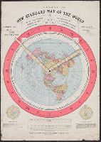
- Published / Created:
- 1892.
- Call Number:
- 11 1892
- Image Count:
- 2
- Resource Type:
- cartographic image
- Found in:
- Beinecke Rare Book and Manuscript Library > Gleason's new standard map of the world : on the projection of J.S. Christopher, Modern College, Blackheath, England ; scientifically and practically correct ; as "it is."
- Creator:
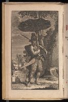
- Defoe, Daniel, 1661?-1731
- Published / Created:
- 1721-22.
- Call Number:
- Defoe 52 p721b
- Image Count:
- 13
- Resource Type:
- Books, Journals & Pamphlets
- Found in:
- Beinecke Rare Book and Manuscript Library > Het leven en de wonderbaare gevallen van Robinson Crusoe : behelzende onder andere ongehoorde uitkomsten een verhaal van zyn agt en twintig jaarig verblyf op een onbewoond eiland, gelegen op de kust van America by de mond van de rivier Oronooque. Alles door liem zelfs beschreven, nu uit het engels vertaald, en met figuren benevens een nette kaart zyner zwerving verrykt : Eerste [-derde] deel.
- Creator:
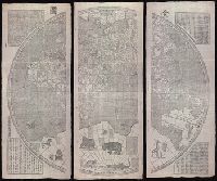
- Verbiest, Ferdinand, 1623-1688.
- Published / Created:
- [Xianfeng geng shen [1860]] and [咸豐庚申[1860]]
- Call Number:
- 11 1860
- Image Count:
- 8
- Resource Type:
- Maps, Atlases & Globes
- Found in:
- Beinecke Rare Book and Manuscript Library > Kun yu quan tu [cartographic material] : [er juan] / [Verbiest, Ferdinand].
- Creator:
- Columbus, Christopher
Hammer, Heinrich, active 1480-1496, cartographer
Rosselli, Francesco di Lorenzo, 1445-1513
- Published / Created:
- ca. 1489
- Call Number:
- Art Storage 1980 157
- Image Count:
- 3
- Found in:
- Beinecke Rare Book and Manuscript Library > Map of the world of Christopher Columbus.
- Creator:
- Plancius, Petrus, 1552-1622
- Published / Created:
- [1594]
- Call Number:
- 11 1594
- Container / Volume:
- BRBL_00002
- Image Count:
- 1
- Resource Type:
- Maps, Atlases & Globes
- Found in:
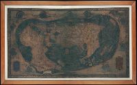
- Beinecke Rare Book and Manuscript Library > Orbis terrarum typus de integro multis in locis emendatus [cartographic material] / auctore Petro Plancio, 1594 ; Ioannes à Duetecum iunior fecit.
- Creator:
- Plancius, Petrus, 1552-1622
- Published / Created:
- [1594]
- Call Number:
- 11 1594
- Container / Volume:
- BRBL_00002
- Image Count:
- 1
- Resource Type:
- Maps, Atlases & Globes
- Found in:
- Beinecke Rare Book and Manuscript Library > Orbis terrarum typus de integro multis in locis emendatus [cartographic material] / auctore Petro Plancio, 1594 ; Ioannes à Duetecum iunior fecit.
- Creator:
- Zuerner, Adam Friedrich, 1680-1742
- Published / Created:
- [1709?]
- Call Number:
- 11 1709
- Container / Volume:
- BRBL_00680
- Image Count:
- 1
- Resource Type:
- Maps, Atlases & Globes
- Found in:
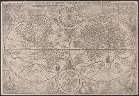
- Beinecke Rare Book and Manuscript Library > Planisphaerium terrestre cum utroque coelesti hemisphaerio, sive diversa orbis terraquei = Vlakke aard-kloot met het beide hemelsch half-rond, of de onder scheidene verbeelding van de land-water-waereld / opera et studio A.F. Zürneri.
- Creator:
- United States. Department of Commerce and Labor. Bureau of Statistics
- Published / Created:
- [1905?]
- Call Number:
- BrSides Double Folio 2018 91
- Image Count:
- 1
- Resource Type:
- Maps, Atlases & Globes
- Found in:
- Beinecke Rare Book and Manuscript Library > Principal transportation routes of the world.
- Creator:
- Schedel, Hartmann, 1440-1514
- Published / Created:
- duodecima mensis Iulij anno salutis n[ost]r[a]e. 1493.
- Call Number:
- 1999 Folio 15
- Image Count:
- 7
- Found in:
- Beinecke Rare Book and Manuscript Library > Registrum huius operis libri cronicarum cu[m] figuris et ÿmagi[ni]bus ab inicio mu[n]di.
- Creator:
- Schedel, Hartmann, 1440-1514
- Published / Created:
- duodecima mensis Iulij anno salutis n[ost]r[a]e. 1493.
- Call Number:
- 1977 Folio 25
- Image Count:
- 7
- Found in:
- Beinecke Rare Book and Manuscript Library > Registrum huius operis libri cronicarum cu[m] figuris et ÿmagi[ni]bus ab inicio mu[n]di.