Search
You Searched For
Search Results
- Published / Created:
- [1795?]
- Call Number:
- 11 1795A
- Container / Volume:
- BRBL_00006
- Image Count:
- 1
- Resource Type:
- Maps, Atlases & Globes
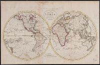
- Found in:
- Beinecke Rare Book and Manuscript Library > A Chart of the World, According to Mercator's Projection, showing the latest discoveries of Capt. Cook.
- Published / Created:
- [1795?]
- Call Number:
- 11 1795A
- Container / Volume:
- BRBL_00006
- Image Count:
- 1
- Resource Type:
- Maps, Atlases & Globes
- Found in:
- Beinecke Rare Book and Manuscript Library > A Chart of the World, According to Mercator's Projection, showing the latest discoveries of Capt. Cook.
- Published / Created:
- 1795
- Call Number:
- 11 1795
- Container / Volume:
- BRBL_00006
- Image Count:
- 1
- Resource Type:
- Maps, Atlases & Globes
- Found in:
- Beinecke Rare Book and Manuscript Library > A Map of the World from the best Authorities.
- Creator:
- Adam and Charles Black (Firm)
Aikman, George, engraver
Barlow, Peter, 1776-1862
- Published / Created:
- 1854]
- Call Number:
- 11 1854
- Container / Volume:
- BRBL_00009
- Image Count:
- 1
- Resource Type:
- Maps, Atlases & Globes
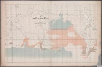
- Found in:
- Beinecke Rare Book and Manuscript Library > A chart of magnetic curves of equal variation / by Peter Barlow.
- Creator:
- Maury, Matthew Fontaine, 1806-1873
- Published / Created:
- 1853
- Call Number:
- 11DB 1851A-2
- Container / Volume:
- BRBL_00774
- Image Count:
- 1
- Resource Type:
- Maps, Atlases & Globes
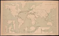
- Found in:
- Beinecke Rare Book and Manuscript Library > A chart showing the favorite resort of the sperm and right whale [cartographic material] / by M.F. Maury L.L.D. Lieut. U.S. Navy ; constructed from Maury's whale chart of the world by Robt. H. Wyman Lieut. U.S.N.
- Creator:
- Great Britain. War Office. General Staff. Geographical Section
- Published / Created:
- 1909
- Call Number:
- BrSides Double Folio 2018 95
- Image Count:
- 1
- Resource Type:
- Maps, Atlases & Globes
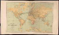
- Found in:
- Beinecke Rare Book and Manuscript Library > Cable map of the world [cartographic material].
- Creator:
- International Telecommunication Union. Bureau
- Published / Created:
- 1896
- Call Number:
- BrSides Folio 2018 130
- Image Count:
- 1
- Resource Type:
- Maps, Atlases & Globes
- Found in:
- Beinecke Rare Book and Manuscript Library > Carte générale des grandes communications télégraphiques du monde / dressée d'après des documents officiels par le Bureau International des Administrations Télégraphiques ; dessinée et gravée par C. v. Hoven.
- Creator:
- United States. Department of the Treasury. Bureau of Statistics
- Published / Created:
- [1900]
- Call Number:
- BrSides Double Folio 2019 2
- Image Count:
- 1
- Resource Type:
- Maps, Atlases & Globes
- Found in:
- Beinecke Rare Book and Manuscript Library > Colonial systems of the world / U.S. Treasury Department, Bureau of Statistics ; O.P. Austin, chief of Bureau.
- Creator:
- United States. Bureau of Statistics
- Published / Created:
- [1898]
- Call Number:
- BrSides Folio 2019 4
- Image Count:
- 1
- Resource Type:
- Maps, Atlases & Globes
- Found in:
- Beinecke Rare Book and Manuscript Library > Colonies, dependencies and protectorates of the world [cartographic material] : showing area and population of the colonies, dependencies, protectorates and spheres of influence.
- Creator:
- Bougainville, Louis-Antoine de, comte, 1729-1811
- Published / Created:
- [1771]
- Call Number:
- BrSides Folio 2019 83
- Collection Title:
- Voyage autour du monde par la frégate du Roi la Boudeuse, et la flûte l'Etoile, en 1766, 1767, 1768
- Image Count:
- 1
- Resource Type:
- Maps, Atlases & Globes
- Found in:
- Beinecke Rare Book and Manuscript Library > Dévelopement de la route des Vaisseaux du Roy la Boudeuse et l'Etiole autour du monde / [by Louis Antoine de Bougainville].