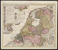
"Cum privil.", Appears in Schenk's Atlas contractus ... [Amsterdam : Peter Schenk, ca. 1700]., Imperfect: Mutilated, with some loss of text. Sheet measures 53.5 x 62 cm. Verso: "19" (?) in ink ms., Insets: Batavorum colon, and Relief shown pictorially.
Publisher:
Peter Schenk?
Subject (Geographic):
East Indies--Maps--Early works to 1800, Netherlands--Maps--Early works to 1800, and New Netherland--Maps--Early works to 1800
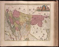
"Cum privil.", "I. Bormeester, eccu.", Bar scales given in "Gemene Duÿtsche Mÿlen 15 in een Graedt" and "Uren gaens de 4 maken 3 Mÿlen"., BEIN 1973 Folio 18: Backed with paper. Ms. no. "41" in upper-right corner. Sheet measures 53.6 x 62.7 cm. No. 40 of 87 maps bound together., Inset: De resterende Eÿlanden van Hollant alhier bÿgevoecht., North oriented to the upper-right., Prime meridian: Ferro., Relief shown pictorially., and Title in Latin; place names in Dutch.
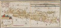
Also shows p, Includes text, col. view of Jakarta, inset of Jakarta, and some cities are marked with gilt., Library copy joined to form 1 sheet., Pars occidentalis --, Prime meridian: Ferro., and Title and notes in Latin. Place-names and scale statements in Dutch.
Publisher:
by Gerard van Keulen aan de Nieuwe brug met previlegie,
Subject (Geographic):
Jakarta (Indonesia)--Maps--Early works to 1800 and Java (Indonesia)--Maps--Early works to 1800
Terra neuf, en de custen van Nieu Vranckryck, Nieu Engeland, Nieu Nederland, Nieu Andalusia, Guiana en Venezuela
Description:
At upper right corner: Fol. 26., Covers the Atlantic Ocean west of, From Renard's Atlas de la navigation et du commerce ... Amsterdam : Chez Louis Renard, 1715., In Latin and Dutch., Includes two decorative cartouches and ill., and Oriented with north to the left.
Publisher:
Gedruckt by L. Renard,
Subject (Geographic):
North Atlantic Ocean--Maps--Early works to 1800
Subject (Name):
Renard, Louis. Atlas de la navigation et du commerce
Subject (Topic):
Nautical charts--North Atlantic Ocean--Early works to 1800
Terra neuf, en de custen van Nieu Vranckryck, Nieu Engeland, Nieu Nederland, Nieu Andalusia, Guiana en Venezuela
Description:
Covers the Atlantic Ocean west of the Azores and Cape Verde Islands, and the coasts of northeastern North America and northern South Amerca., In Latin and Dutch., Includes two decorative cartouches and ill., Ms. "25" in upper right margin., and Oriented with nort
Publisher:
Gedruckt by Fredrick de Wit in de Kalverstraet,
Subject (Geographic):
North Atlantic Ocean--Maps--Early works to 1800
Subject (Topic):
Nautical charts--North Atlantic Ocean--Early works to 1800
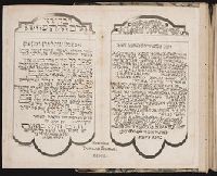
Inserted folding leaf : ""Effigies tabvlae smaragdinae."" : 2 representations of the emerald tablet of Hermes. In Hebrew on the left and an exotic tongue (representing Chaldean?) on the right.
Description:
Engraved plate, 185 x 235 mm., tipped in inside front cover., MS consists of 3 loose quires in cover., On paper., and Single columns 175 x 120 mm. bordered in pencil, without ruling.
Subject (Name):
Hermes, Trismegistus. Tabula smaragdina
Subject (Topic):
Alchemy and Ancient and Mystical Order Rosae Crucis
Maps numbered in manuscript 1 to 97; wanting 2, 42, 45, 51, 52, 74, 85, 89, 92 and 93., Some maps dated 1704-1717, others without date., Some maps first published in J. van Keulen's De nieuwe groote lichtende zee-fackel and G. van Keulen's De groote nieuwe vermeerderde zee-atlas., Title devised by cataloger., and With engraved title-page: "Gedruckt tot Amsterdam bÿ Ioannes van Keulen, boeck zee-kaardt verkooper en graad-boogh maker aande oost zÿde vande Nieuwebrug inde gekroonde Lootsman. Met previlegie ... 1718"; engraved title-page has same illustration as J. van Keulen's De groote nieuwe vermeerderde zee-atlas ofte water-werelt ... 1681.
Publisher:
s.n.,
Subject (Name):
Keulen, Gerard van., Keulen, Johannes van, 1654-1715. Groote nieuwe vermeerderde zee-atlas ofte water-waereld., Keulen, Johannes van, 1654-1715. Nieuwe groote lichtende zee-fakkel., Schenk, Peter, 1660-1718 or 1719., and Valck, G. (Gerard), 1651 or 1652-1726.