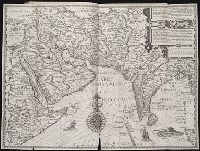
Affbeeldinghe der custen des landts genaempt terra do Natal, item van alle de custen van Coffala, Mozambique, Melinde and Typus orarum maritimarum Guineae, Manicongo, & Angôlae ultra promontorium Bonae Spei.
Description:
Appears in the author's Itinerario, voyage ofte schipvaert van Jan Huygen van Linschoten naer Oost ofte Portugaels Indien., Companion map to Typus orarum maritimarum Guineae, Manicongo, & Angôlae ultra promontorium Bonae Spei ..., and Includes decorative carto
Publisher:
Cornelis Claesz?,
Subject (Geographic):
Africa, Eastern--Maps--Early works to 1800
Subject (Name):
Claesz, Cornelis, approximately 1546-1609, Langren, Arnold Florent van, 1580-1644, and Linschoten, Jan Huygen van, 1563-1611. Itinerario, voyage ofte schipvaert van Jan Huygen van Linschoten naer Oost ofte Portugaels Indien
Subject (Topic):
Coasts--Africa, Eastern--Maps--Early works to 1800
Affbeeldinghe der custen des landts genaempt terra do Natal, item van alle de custen van Coffala, Mozambique, Melinde and Typus orarum maritimarum Guineae, Manicongo, & Angôlae ultra promontorium Bonae Spei.
Description:
Appears in the author's Itinerario, voyage ofte schipvaert van Jan Huyge, Companion map to Typus orarum maritimarum Guineae, Manicongo, & Angôlae ultra promontorium Bonae Spei ..., Has watermark., and Includes decorative cartouche and compass rose and col. ill.
Publisher:
Cornelis Claesz?,
Subject (Geographic):
Africa, Eastern--Maps--Early works to 1800
Subject (Name):
Claesz, Cornelis, approximately 1546-1609, Langren, Arnold Florent van, 1580-1644, and Linschoten, Jan Huygen van, 1563-1611. Itinerario, voyage ofte schipvaert van Jan Huygen van Linschoten naer Oost ofte Portugaels Indien
Subject (Topic):
Coasts--Africa, Eastern--Maps--Early works to 1800
Navigatio ac itinerarivm Iohannis Hvgonis Linscotani in Orientalem sive Lvsitanorvm Indiam
Image Count:
1
Description:
[Scale ca. 1:13,500,000]., Bound in following page 12., Map has significant tear along bottom center fold and one tear at bottom left portion., and Some ink from place names have bled through to the verso.
Subject (Geographic):
Afghanistan --Maps, Egypt --Maps --Early works to 1800, India --Maps, Iran --Maps --Early works to 1800, Iraq --Maps, Pakistan --Maps, and Saudi Arabia --Maps
Subject (Name):
Claesz, Cornelis, ca. 1546-1609, publisher, Elzevier, Gillis, bookseller, Hendricksz, Aelbrecht, fl. 1573-1605, printer, and Langren, Arnold Florent van, 1580-1644
Subject (Topic):
Voyages and travels --Early works to 1800
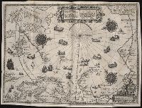
Collection Created:
Hagae-Comitis : Ex officina Alberti Henrici, impensis authoris & Cornelii Nicolai, prostantque apud Aegidium Elseuirum, anno 1599
Barentsz, Willem, ca. 1550-1597. Deliniatio cartae trium navagationum Claesz, Cornelis, ca. 1546-1609 Duetecum, Baptista
Published / Created:
1598
Call Number:
Taylor 219
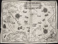
Collection Title:
Navigatio ac itinerarivm Iohannis Hvgonis Linscotani in Orientalem sive Lvsitanorvm Indiam
Image Count:
1
Description:
Bound in following page 16., Map has four small tears along left, right and bottom edges of map, as well as a tear along the bottom center fold., and Scale not given.
Subject (Geographic):
Arctic Ocean --Maps, Finland --Maps --Early works to 1800, Greenland --Maps --Early works to 1800, Iceland --Maps --Early works to 1800, Norway --Maps --Early works to 1800, and Sweden --Maps
Subject (Name):
Elzevier, Gillis, bookseller, Hendricksz, Aelbrecht, fl. 1573-1605, printer, and Langren, Arnold Florent van, 1580-1644
Subject (Topic):
Voyages and travels --Early works to 1800
Collection Created:
Hagae-Comitis : Ex officina Alberti Henrici, impensis authoris & Cornelii Nicolai, prostantque apud Aegidium Elseuirum, anno 1599
Barentsz, Willem, ca. 1550-1597. Deliniatio cartae trium navagationum Claesz, Cornelis, ca. 1546-1609 Duetecum, Baptista
Published / Created:
1598
Call Number:
Pequot +L65
Collection Title:
Nauigatio ac itinerarium Iohannis Hugonis Linscotani in Orientalem siue Lusitanorum Indiam
Image Count:
1
Description:
Bound in following page 16., In pencil on bottom left panel of right verso: 91 1 [upside down when unfolded; upright orientation when folded]., In pencil on middle right panel of left verso: 17-2., In pencil on top right panel of right verso: +., Map has several tears now repaired on verso., and Scale not given.
Subject (Geographic):
Arctic Ocean --Maps, Finland --Maps --Early works to 1800, Greenland --Maps --Early works to 1800, Iceland --Maps --Early works to 1800, Norway --Maps --Early works to 1800, and Sweden --Maps
Subject (Name):
Elzevier, Gillis, bookseller, Hendricksz, Aelbrecht, fl. 1573-1605, printer, and Langren, Arnold Florent van, 1580-1644
Subject (Topic):
Voyages and travels --Early works to 1800
Collection Created:
Hagae-Comitis : Ex officina Alberti Henrici, impensis authoris & Cornelii Nicolai, prostantque apud Aegidium Elseuirum, anno 1599
Navigatio ac itinerarivm Iohannis Hvgonis Linscotani in Orientalem sive Lvsitanorvm Indiam
Image Count:
1
Description:
[Scale ca. 1:13,500,000]., Bound in following page 22., Map has several areas of small brown and yellow stains on the recto as well as two areas of linear white chalky lines on the verso; one forms a cross., and Map has significant tear along bottom center fold.
Subject (Geographic):
Borneo --Maps, China --Maps --Early works to 1800, Indonesia --Maps, Japan --Maps --Early works to 1800, Java (Indonesia) --Maps --Early works to 1800, and Philippines --Maps
Subject (Name):
Claesz, Cornelis, ca. 1546-1609, publisher, Elzevier, Gillis, bookseller, Hendricksz, Aelbrecht, fl. 1573-1605, printer, and Langren, Arnold Florent van, 1580-1644
Subject (Topic):
Voyages and travels --Early works to 1800
Collection Created:
Hagae-Comitis : Ex officina Alberti Henrici, impensis authoris & Cornelii Nicolai, prostantque apud Aegidium Elseuirum, anno 1599
Exacta et accurata delineatis cum orarum maritimarum tum etjam locorum terrestrium and Waarachtige wtworpinghe ofte afbeeldinge van alle dje custen end landen
Description:
Appears in the author's Itinerario. 1596., Backed with paper., Has watermark., Includes ill., Latin and Dutch., Oriented with north to the left., and Relief shown pictorially.
Publisher:
C. Claesz,
Subject (Geographic):
Southeast Asia--Maps--Early works to 1800
Subject (Name):
Langren, Arnold Florent van, 1580-1644, Langren, Henricus F. ab (Henricus Florentius), ca. 1574-1648, engraver, Linschoten, Jan Huygen van, 1563-1611, and Linschoten, Jan Huygen van, 1563-1611. Itinerario, voyage ofte schipvae
Subject (Topic):
Nautical charts--South China Sea--Early works to 1800 and Nautical charts--Southeast Asia--Early works to 1800
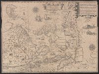
Afheeldinghe der custen des landts Guinea, Manicongo, ende Angôla, ende voorts tot voorby de C. de boa esperança and Delineatio orarum maritimarum, terrae vulgo indigetatae terra do Natal item Sofalae, Mozambicae & Melindae ...
Description:
Appears in the author's, Companion map to Delineatio orarum maritimarum, terrae vulgo indigetatae terra do Natal item Sofalae, Mozambicae & Melindae ..., Has watermark., Relief shown pictorially., and Title in Latin and Dutch. Place names in Latin and Portuguese.
Publisher:
Arnold Florent van Langren,
Subject (Geographic):
Africa, Southern--Maps--Early works to 1800
Subject (Name):
Langren, Arnold Florent van, 1580-1644 and Linschoten, Jan Huygen van, 1563-1611. Itinerario, voyage ofte schipvaert van Jan Huygen van Linschoten naer Oost ofte Portugaels Indien
Subject (Topic):
Coasts--Africa, Southern--Maps--Early works to 1800
Afheeldinghe der custen des landts Guinea, Manicongo, ende Angôla, ende voorts tot voorby de C. de boa esperança and Delineatio orarum maritimarum, terrae vulgo indigetatae terra do Natal item Sofalae, Mozambicae & Melindae ...
Description:
Appears in the author's Itinerario, voyage ofte schipvaert van Jan Huygen van Linschoten naer Oost ofte Portugaels Indien., Includes views of Ascension Island and Sain, Relief shown pictorially., and Title in Latin and Dutch. Place names in Latin and Portuguese.
Publisher:
Arnold Florent van Langren,
Subject (Geographic):
Africa, Southern--Maps--Early works to 1800
Subject (Name):
Langren, Arnold Florent van, 1580-1644 and Linschoten, Jan Huygen van, 1563-1611. Itinerario, voyage ofte schipvaert van Jan Huygen van Linschoten naer Oost ofte Portugaels Indien
Subject (Topic):
Coasts--Africa, Southern--Maps--Early works to 1800