Search
You Searched For
Search Results
- Published / Created:
- [ca. 1840-1841]
- Call Number:
- WA MSS S-2050 J774
- Image Count:
- 15
- Resource Type:
- Archives or Manuscripts
- Found in:
- Beinecke Rare Book and Manuscript Library > Joseph Valliere Spanish land grant papers
- Creator:
- Vicuña, Cecilia, 1948-
- Published / Created:
- 2012
- Call Number:
- 2014 Folio 20
- Image Count:
- 9
- Resource Type:
- Furnishings & Decorative Arts
- Found in:
- Beinecke Rare Book and Manuscript Library > Chanccani Quipu / Cecilia Vicuña.
- Creator:
- Abreu de Galindo, Juan de.
- Published / Created:
- MDCCLXIV [1764]
- Call Number:
- BrSides 2019 4
- Image Count:
- 9
- Resource Type:
- Maps, Atlases & Globes
- Found in:
- Beinecke Rare Book and Manuscript Library > The history of the discovery and conquest of the Canary Islands : translated from a Spanish manuscript lately found in the island of Palma : with an enquiry into the origin of the ancient inhabitants : to which is added, A description of the Canary Island
- Published / Created:
- 1864-1962
- Call Number:
- WA MSS S-2885
- Collection Title:
- Sugg and McDonald family papers
- Container / Volume:
- Box 1 | [1]
- Image Count:
- 67
- Resource Type:
- Archives or Manuscripts
- Found in:
- Beinecke Rare Book and Manuscript Library > Correspondence
- Creator:
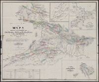
- Ringgold, Cadwalader, 1802-1867
- Published / Created:
- [1851?]
- Call Number:
- 844cea Sa52 1850A
- Container / Volume:
- BRBL_00614
- Image Count:
- 1
- Resource Type:
- Maps, Atlases & Globes
- Found in:
- Beinecke Rare Book and Manuscript Library > Chart of the Farallones and entrance to the bay of San Francisco : California / by Cadwalader Ringgold, Commander, U.S. Navy ; assisted by Simon F. Blunt, Lieut., U.S. Navy, 1850.
- Creator:
- Ringgold, Cadwalader, 1802-1867
- Published / Created:
- [1851?]
- Call Number:
- 844cea Sa52 1850B
- Container / Volume:
- BRBL_00614
- Image Count:
- 1
- Resource Type:
- Maps, Atlases & Globes
- Found in:
- Beinecke Rare Book and Manuscript Library > Chart of the bay of San Pablo, Straits of Carquines, and part of the bay of San Francisco : California / by Cadwalader Ringgold, Commander, U.S. Navy ; assisted by Simon F. Blunt, Lieut., U.S.N., 1850.
- Creator:
- Ringgold, Cadwalader, 1802-1867
- Published / Created:
- [1851?]
- Call Number:
- 844cea Sa52 1850A
- Container / Volume:
- BRBL_00614
- Image Count:
- 1
- Resource Type:
- Maps, Atlases & Globes
- Found in:
- Beinecke Rare Book and Manuscript Library > Chart of the Farallones and entrance to the bay of San Francisco : California / by Cadwalader Ringgold, Commander, U.S. Navy ; assisted by Simon F. Blunt, Lieut., U.S. Navy, 1850.
- Creator:
- Hendges, M
- Published / Created:
- 1904
- Call Number:
- 70gme 1904
- Container / Volume:
- BRBL_00359
- Image Count:
- 1
- Resource Type:
- Maps, Atlases & Globes
- Found in:
- Beinecke Rare Book and Manuscript Library > Intercontinental railway map : prepared under the direction of the permanent Pan American Railway Committee authorized by the Second International Conference of American States / M. Hendges.
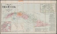
- Creator:
- Smith, John L., 1846-1921
- Published / Created:
- 1897
- Call Number:
- 855 1897B
- Container / Volume:
- BRBL_00641
- Image Count:
- 1
- Resource Type:
- Maps, Atlases & Globes
- Found in:
- Beinecke Rare Book and Manuscript Library > Mapa de la isla de Cuba.
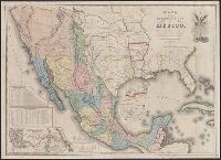
- Creator:
- Disturnell, John, 1801-1877
- Published / Created:
- 1847
- Call Number:
- 88 1847G
- Container / Volume:
- BRBL_00645
- Image Count:
- 1
- Resource Type:
- Maps, Atlases & Globes
- Found in:
- Beinecke Rare Book and Manuscript Library > Mapa de los Estados Unidos de Méjico / segun lo organizado y definido por las varias actas del Congreso de dicha República y construido por las mejores autoridades.
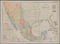
- Creator:
- Disturnell, John, 1801-1877
- Published / Created:
- 1935
- Call Number:
- 88 1847H
- Container / Volume:
- BRBL_00645
- Image Count:
- 1
- Resource Type:
- Maps, Atlases & Globes
- Found in:
- Beinecke Rare Book and Manuscript Library > Mapa de los Estados Unidos de Méjico / segun lo organizado y definido por las varias actas del Congreso de dicha República y construido por las mejores autoridades ; lo publican, J. Disturnell.
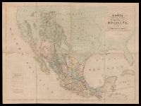
- Published / Created:
- 1845]
- Call Number:
- 88 1845D
- Container / Volume:
- BRBL_00645
- Image Count:
- 1
- Resource Type:
- Maps, Atlases & Globes
- Found in:
- Beinecke Rare Book and Manuscript Library > Carta geografica general de la republica Mexicana / formada el ano de 1845, con los datos que reunio la seccion de Geografia del Ministerio de la Guerra, por el General de Brigada Pedro Garcia Conde.
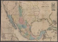
- Creator:
- Disturnell, John, 1801-1877
- Published / Created:
- 1846
- Call Number:
- 88 1846G
- Container / Volume:
- BRBL_00645
- Image Count:
- 1
- Resource Type:
- Maps, Atlases & Globes
- Found in:
- Beinecke Rare Book and Manuscript Library > Mapa de los Estados Unidos de Méjico / según lo organizado y definido por las varias actas del Congreso de dicha República y construido por las mejores autoridades ; lo publican J. Disturnell.
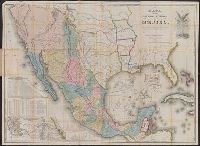
- Creator:
- Disturnell, John, 1801-1877
- Published / Created:
- 1847
- Call Number:
- 88 1847N
- Container / Volume:
- BRBL_00645
- Image Count:
- 1
- Resource Type:
- Maps, Atlases & Globes
- Found in:
- Beinecke Rare Book and Manuscript Library > Mapa de los Estados Unidos de Méjico / segun lo organizado y definido por las varias actas del Congreso de dicha Républica y construido por las mejores autoridades.
- Creator:
- E. & G.W. Blunt (Firm)
- Published / Created:
- 1849
- Call Number:
- 88cea 1849
- Container / Volume:
- BRBL_00648
- Image Count:
- 1
- Resource Type:
- Maps, Atlases & Globes
- Found in:
- Beinecke Rare Book and Manuscript Library > West coast of North America from the Gulf of Dulce to San Francisco.
- Creator:
- Cox, Gustavo
- Published / Created:
- 1865
- Call Number:
- 88192gfc 1865
- Container / Volume:
- BRBL_00653
- Image Count:
- 1
- Resource Type:
- Maps, Atlases & Globes
- Found in:
- Beinecke Rare Book and Manuscript Library > Mapa de los distritos minerales de San Antonio, El Triunfo, Las Cacachilas y Isla de Carmen : Baja California, República de México / recopilado y delineado por Don Gustavo Cox, ingeniero de minas.
- Creator:
- Ferrer, Fermin
- Published / Created:
- 1855
- Call Number:
- 895 1855
- Container / Volume:
- BRBL_00659
- Image Count:
- 1
- Resource Type:
- Maps, Atlases & Globes
- Found in:
- Beinecke Rare Book and Manuscript Library > Geographical map of the Republic of Nicaragua : with three plans and views / by Fermin Ferrer, Governor of the Western Dept.
- Creator:
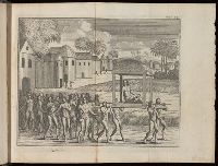
- Herrera y Tordesillas, Antonio de, -1625
- Call Number:
- Z6 22g
- Image Count:
- 1
- Resource Type:
- Books, Journals & Pamphlets
- Found in:
- Beinecke Rare Book and Manuscript Library > The general history of the vast continent and islands of America : commonly call'd the West-Indies, from the first discovery thereof : with the best accounts the people could give of their antiquities / collected from the original relations sent to the kings of Spain, by Antonio de Herrera ; historiographer to His Catholick Majesty ; translated into English by Capt. John Stevens ... ; illustrated with cutts and maps.
- Creator:
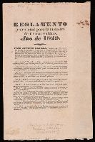
- Coahuila and Texas (Mexico). Comisionado General para el Repartimiento de Tierras Valdias
- Published / Created:
- 1829]
- Call Number:
- Zc52 829co
- Image Count:
- 4
- Found in:
- Beinecke Rare Book and Manuscript Library > Reglamento provisional para la mensura de tierras valdias. Año de 1829.