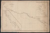
Insets: Harbour of Monterey / surveyed by the officers of the U.S.S. Dale ... 1843. Scale [ca. 1:30,500] -- The Harbour of San Francisco / surveyed by Captn. F.W. Beechey -- [Coast from Port Venderas to San Francisco]. Scale [ca. 1:5,650,000]. and Shows route of "Corvetas Descubierta y Atrevida en 1791."
Publisher:
E. & G.W. Blunt,
Subject (Name):
Beechey, Frederick William, 1796-1856. Harbour of San Francisco
Subject (Topic):
Harbors--California--Monterey--Maps, Naut, Nautical charts--California, Nautical charts--California--Monterey Bay, Nautical charts--California--San Francisco Bay Area, and Nautical charts--Central America
Includes insets of "Harbour of San Francisco, surveyed by Capt. F.W. Beechey" and the west coast from Port Venderas to San Francisco., Relief shown by hachures. Depths shown by soundings., and Shows route of "Corvetas Descubierta y Atrevida en 1791."
Publisher:
E. & G.W. Blunt,
Subject (Name):
Beechey, Frederick William, 1796-1856. Harbour of San Francisco
Subject (Topic):
Harbors--California--Monterey--Maps, Naut, Nautical charts--California, Nautical charts--California--Monterey Bay, Nautical charts--California--San Francisco Bay Area, and Nautical charts--Central America