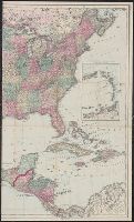
In bottom left margin: Printed by Wm. Duffee., In top margin: American atlas., Includes text, ill., and insets of "Western part of the Aleutian Islands" and "Comparative altitudes of the mountains, towns &c. of North America.", and Possibly from 1923 ed. of Tanner's A new American atlas.
Publisher:
H.S. Tanner,
Subject (Geographic):
NorthAmerica--Maps
Subject (Name):
Tanner, Henry Schenck, 1786-1858. New American atlas
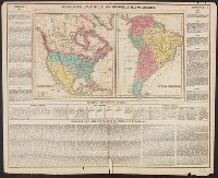
Appears in Carey's Complete historical chronological, and geographical American atlas. Philadelphia, Pa. : H.C. Carey & I. Lea, 1822., Historical and descriptive text in margin., North America -- South America., and Relief shown pictorially.
Publisher:
H.C. Carey & I. Lea,
Subject (Geographic):
NorthAmerica--Maps
Subject (Name):
Carey & Lea, Carey, Henry Charles, 1793-1879. A complete historical, chronological, and geographical American atlas, Lea, Isaac, 1792-1886, and Young & Delleker
Continuation inset: Central America [12 x 17 cm., scale ca. 1:11,000,000] and Includes time and distance table, list of Presidents, 1860 population statistics, and explanation of British American possessions.
Publisher:
Haasis & Lubrecht,
Subject (Geographic):
NorthAmerica--Maps
Subject (Name):
B.B. Russell & Co., publisher, Ch. Lubrecht & Co., publisher, Haasis & Lubrecht, publisher, J. & D. Beatson Co., publisher, and Lubrecht & Co., publisher
Shows proposed railroads primarily in the North Central United States and Canada; bullseye centering on Mackinaw City and the Great Lakes region and the Straits of Mackinaw connecting Lake Michigan and Lake Huron; Michigan counties, major cities and towns
Publisher:
Middleton, Strobridge & Co.,
Subject (Geographic):
Great Lakes (NorthAmerica)--Maps
Subject (Name):
Canadian Pacific Railway Company--Maps and Northern Pacific Railroad Company--Maps
Appears in Winterbotham's The American atlas ... New York : J. Reid, 1796., Includes numbered list of states., Prime meridian: London., and Relief shown pictorially.
Publisher:
John Reid,
Subject (Geographic):
NorthAmerica--Maps--Early works to
Subject (Name):
Reid, John, 1764?-1828 and Winterbotham, William, 1763-1829. American atlas .
"Longit. west from Ferro I.", "Printed for John Bowles at the Black Horse in Cornhill & Carington Bowles in St. Pauls Church yard, London.", and Differs from other copy in coloration. Only boundaries are colored, emphasis is on showing the internal boundaries o
Publisher:
Printed for John Bowles,
Subject (Geographic):
NorthAmerica--Maps--Early works to
Subject (Name):
Bowles, Carington, 1724-1793, Bowles, John, 1701-1779, and Palairet, Jean, 1697-1774