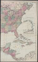
In lower margin: London: Published 1 Jan. 1795 by A. Arrowsmith, No. 10 Soho Square ... additions to 1802., Includes notes., and Relief shown by hachures.
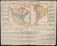
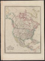
In bottom left margin: Printed by Wm. Duffee., In top margin: American atlas., Includes text, ill., and insets of "Western part of the Aleutian Islands" and "Comparative altitudes of the mountains, towns &c. of North America.", and Possibly from 1923 ed. of Tanner's A new American atlas.
Publisher:
H.S. Tanner,
Subject (Geographic):
Central America--Maps and North America--Maps
Subject (Name):
Tanner, Henry Schenck, 1786-1858. New American atlas
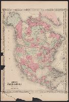
Appears in Carey's Complete historical chronological, and geographical American atlas. Philadelphia, Pa. : H.C. Carey & I. Lea, 1822., Historical and descriptive text in margin., North America -- South America., and Relief shown pictorially.
Publisher:
H.C. Carey & I. Lea,
Subject (Geographic):
North America--Maps and South America--Maps
Subject (Name):
Carey & Lea, Carey, Henry Charles, 1793-1879. A complete historical, chronological, and geographical American atlas, Lea, Isaac, 1792-1886, and Young & Delleker
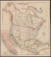
Appears in Johnson's New illustrated family atlas .... 1866., Numbers in right margin: 15, 16., On verso: Geographical index, or ready reference, [p.] 27, 28., Prime meridians: Washington and Greenwich., and Relief shown by hachures.
Publisher:
A.J. Johnson?,
Subject (Geographic):
North America--Maps
Subject (Name):
Johnson, A. J. (Alvin Jewett), 1827-1884. Johnson's New illustrated family atlas of the world
Includes tables of distances for overland routes and sea routes., Inset: Map of the gold region California. Scale [ca. 1:4,752,000]., Prime meridian: Washington, D.C., and Relief shown by hachures.
Includes tables of distances for overland routes and sea routes., Inset map: Map of the gold region, California., Prime meridian: Washington, D.C., and Relief shown by hachures.
Appears in Wyld's New general atlas. London, 1854. Cf. Phillips, Maps of America, p. 607., In upper right margin: 36., Relief shown by hachures., and Yale's copy stamped on verso: Yale University Library, Karpinski-Von Wieser Map Collection.