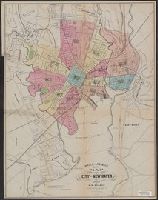
Covers also town of North Andover and a portion of the City of Lawrence, Massachusetts., Imperfect: Mutilated with slight loss of text. Mounted on board., Relief shown by hachures., and Shows buildings with names of property owners.
Publisher:
Pendleton's Lithogy.,
Subject (Geographic):
Andover (Mass. : Town)--Buildings, structures, etc.--Maps., Andover (Mass. : Town)--Maps., Lawrence (Mass.)--Maps., and North Andover (Mass. : Town)--Maps.
Subject (Name):
Pendleton's Lithography.
Subject (Topic):
Landowners--Massachusetts--Andover (Town)--Maps., Landowners--Massachusetts--Lawrence--Maps., Landowners--Massachusetts--North Andover (Town)--Maps., Real property--Massachusetts--Andover (Town)--Maps., Real property--Massachusetts--Lawrence--Maps., and Real property--Massachusetts--North Andover (Town)--Maps.
Imperfect: upper left corner cut-out, with some loss of text., Includes text in upper right corner: Population s, and Map of London showing railways, stations, postal boundaries, parks, omnibus and tram routes, steamboat piers and steamboat routes.
Publisher:
Published by Letts, Son & Co., London Bridge, E.C.,
Copy 1: Advertising on verso: Evan Evans ... tinsmith, plumber, and gas-fitter; John C. Ritter ... marble and granite monuments; the Smith Granite Co., Westerley, R.I.
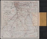
With original covers. Manuscript annotations on cover.
Publisher:
Matthews Northrup Co.,
Subject (Geographic):
Erie County (N.Y.)--Maps and Niagara County (N.Y.)--Maps
Subject (Topic):
Cycling--New York (State)--Erie County--Maps, Cycling--New York (State)--Niagara County--Maps, Roads--New York (State)--Erie County--Maps, and Roads--New York (State)--Niagara County--Maps
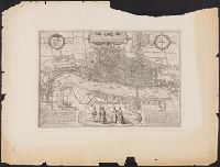
"The Topographic Etching Co., ph. sc.", Alternate title: London, 1572, by Braun and Hogenberg., Bird's-eye-view., Facsimile., Has watermark., Includes 2 texts in Latin, 2 coats of arms, and illus. of human figures., Place names in English., and Reproduced from Braun
Publisher:
Topographical Society of London,
Subject (Geographic):
London (England)--Aerial views--Early works to 1800--Facsimiles
"2764"., Compiled chiefly from the Surveys by Captains Flinders, Blackwood, Stanley, Yule & Denham 1802-60, with additions from various surveys to 1885., Includes large corrections to Mar. 1896, and small corrections to "IX.11.", Prime meridian: Greenwich., and R
Subject (Geographic):
Coral Sea--Maps and Great Barrier Reef (Qld.)--Maps
Map of the improved part of the province of Pennsylvania
Description:
2nd state of 2 known states. Distinguishing features of 2nd state: "Four [sic] long lines of text have been added at right of the Narrows of the Susquehannah at Nelson's Ferry. A road now leads east from Carlisle direct to Pine Ford" (Wheat and Brun 89).
Publisher:
sold by the author Nicholas Scull,
Subject (Geographic):
Pennsylvania--Administrative and political divisions--Maps--Early works to 1800 and Pennsylvania--Maps--Early works to 1800
Subject (Name):
Davis, John, fl. 1756-1759, Penn, Richard, 1706-1771. dedication, Penn, Thomas, 1702-1775. dedication, and Turner, James, d. 1759. engraver
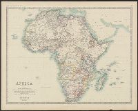
Boundaries hand colored., From Johnston's Royal atlas of modern geography., Prime meridian: Greenwich., Relief shown by hachures., Upper left: Keith Johnston's general atlas., and Upper right: 39.
Subject (Geographic):
Africa--Maps
Subject (Name):
Johnston, Alexander Keith, 1804-1871. Royal atlas of modern geography and W. & A.K. Johnston Limited
Boundaries hand colored., From Johnston's Royal atlas of modern geography?, Prime meridian: Greenwich., Relief shown by hachures., and Upper right: 36.
Subject (Geographic):
Africa--Maps
Subject (Name):
Johnston, Alexander Keith, 1804-1871. Royal atlas of modern geography and W. & A.K. Johnston Limited, publisher