Skip to search
Skip to main content
Skip to first result
Search
You Searched For
Resource Type
cartographic image
Language
English
Search Results
Creator:
Published / Created:
[1884?]
Call Number:
WA Prints +107
Image Count:
1
Resource Type:
cartographic image
Description:
Relief shown pictorially.
Publisher:
publisher not identified
Subject (Geographic):
Deadwood (S.D.)
Found in:
Beinecke Rare Book and Manuscript Library > "Times" view of Deadwood
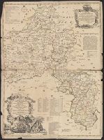
Creator:
Published / Created:
MDCCLXXX [1780]
Call Number:
1973 +100
Image Count:
1
Resource Type:
cartographic image
Description:
Coordinates based on index map ([1] leaf of plates).
Publisher:
James Rennell
Subject (Geographic):
Bengal (India), Bihar and Orissa (India), India, Bengal., and Bihar and Orissa.
Subject (Topic):
Maps
Found in:
Beinecke Rare Book and Manuscript Library > A Bengal atlas : containing maps of the theatre of war and commerce on that side of Hindoostan
Published / Created:
[1768?]
Call Number:
2003 Folio 85
Image Count:
1
Resource Type:
cartographic image
Description:
BEIN 2003 Folio 85: No. 7 of 45 maps bound together with binder's spine title: Atlas of America; manuscript table of contents. Bookplate of Paul Mellon.
Publisher:
Published according to Act of Parliament by Thos. Jefferys, the corner of St. Martins Lane, Charing Cross
Subject (Geographic):
Québec (Québec) and United States
Subject (Topic):
Québec Campaign, Québec, 1759 and History
Found in:
Beinecke Rare Book and Manuscript Library > A correct plan of the environs of Quebec, and of the battle fought on the 13th September, 1759 : together with a particular detail of the French lines and batteries, and also of the encampments, batteries and attacks of the British army, and the investiture of that city under the command of Vice Admiral Saunders, Major General Wolfe, Brigadier General Monckton, and Brigadier General Townshend drawn from the original surveys taken by the engineers of the army
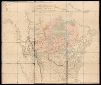
Creator:
Published / Created:
[1820]
Call Number:
71 1820B
Image Count:
1
Resource Type:
cartographic image
Description:
BEIN 71 1820B: Dissected and mounted on linen.
Publisher:
Published Jan. 1, 1795 by A. Arrowsmith, No. 10 Soho Square
Subject (Geographic):
North America
Found in:
Beinecke Rare Book and Manuscript Library > A map exhibiting all the new discoveries in the interior parts of North America : inscribed by permission to the honorable governor and company of adventurers of England trading into Hudsons Bay, in testimony of their liberal communications to their most obedient and very humble servant, A. Arrowsmith, Hydrographer to His Majesty
Creator:
Published / Created:
[1698]
Call Number:
Zc20 697heg
Collection Title:
Map [1]. New discovery of a vast country in America.
Image Count:
1
Resource Type:
cartographic image
Description:
Relief shown pictorially.
Publisher:
Printed for M. Bentley, J. Tonson, H. Bonwick, T. Goodwin, and S. Manship
Subject (Geographic):
North America, Mississippi River Valley, Mississippi River Valley., and North America.
Subject (Topic):
Maps
Found in:
Beinecke Rare Book and Manuscript Library > A map of a large country newly discovered in the Northern America situated between New Mexico and the frozen sea together with the course of the great river Meschasipi / [cartographic material]
Creator:
Published / Created:
[1755 or 1759?]
Call Number:
2003 Folio 85
Image Count:
1
Resource Type:
cartographic image
Description:
BEIN Roll Map 194: Imperfect: somewhat brittle, chipped, torn in places, with minimal loss of map image. Joined sheets measure 100 x 109 cm. Mounted on linen. In manuscript on verso: Jefferys's Map of New England 1755.
Publisher:
Thomas Jefferys
Subject (Geographic):
New England, New England., and United States New England. lcsh
Subject (Topic):
Maps
Found in:
Beinecke Rare Book and Manuscript Library > A map of the most inhabited part of New England : containing the provinces of Massachusets Bay and New Hampshire, with the colonies of Conecticut and Rhode Island, divided into counties and townships : the whole composed from actual surveys and its situation adjusted by astronomical observations
Creator:
Published / Created:
[1750]
Call Number:
3218 1750
Collection Title:
Large English atlas ...
Image Count:
1
Resource Type:
cartographic image
Description:
BEIN 3218 1750: Hand colored.
Publisher:
Printed for T. Bowles in St. Paul's Church Yard, John Bowles and Son, in Cornhill, Robt. Sayer and John Tinney in Fleet Street
Subject (Geographic):
Oxfordshire (England)
Found in:
Beinecke Rare Book and Manuscript Library > A new improved map of Oxfordshire : from the best surveys and intelligences, divided into its hundreds : shewing the several roads and true measured distances between town and town : also the rectories and vicarages, the parks and seats of the nobility & gentry, with other useful particulars : regulated by astronomical observations
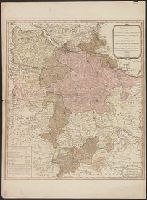
Creator:
Published / Created:
June 1st, 1789.
Call Number:
3635 1789
Image Count:
1
Resource Type:
cartographic image
Description:
BEIN 1982 Folio 10: Sheet measures 73 x 55 cm. Armorial bookplate: Charles Abbot. No. 21 of 42 maps bound together.
Publisher:
Published by W. Faden, Geographer to the King, Charing Cross
Subject (Geographic):
Lower Saxony (Germany)
Subject (Name):
Brunswick-Lüneburg, House of.
Found in:
Beinecke Rare Book and Manuscript Library > A new map of the King of Great Britain's dominions in Germany or the Electorate of Brunswick-Luneburg and its dependencies
Creator:
Published / Created:
June 1st, 1789.
Call Number:
1982 Folio 10
Image Count:
1
Resource Type:
cartographic image
Description:
BEIN 1982 Folio 10: Sheet measures 73 x 55 cm. Armorial bookplate: Charles Abbot. No. 21 of 42 maps bound together.
Publisher:
Published by W. Faden, Geographer to the King, Charing Cross
Subject (Geographic):
Lower Saxony (Germany)
Subject (Name):
Brunswick-Lüneburg, House of.
Found in:
Beinecke Rare Book and Manuscript Library > A new map of the King of Great Britain's dominions in Germany or the Electorate of Brunswick-Luneburg and its dependencies
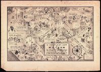
Creator:
Call Number:
BrSides Double Folio 2016 34
Image Count:
1
Resource Type:
cartographic image
Description:
BEIN BrSides Double Folio 2016 34: Mounted on board. Stamp in upper left corner, "Manhattan." Scant manuscript annotations at bottom.
Subject (Geographic):
Harlem (New York, N.Y.), New York (State), and New York
Subject (Name):
Cotton Club., Connie’s Inn (New York, N.Y.), Small’s Paradise (Nightclub : Harlem, New York, N.Y.), Lafayette Theater (New York, N.Y. : 132nd Street), Club Hot-Cha (New York, N.Y.), Yeah Man (Nightclub : New York, N.Y.), Tillie's (Nightclub : New York, N.Y.), Radium Club (New York, N.Y.), Calloway, Cab, 1907-1994, Bentley, Gladys, Robinson, Bill, 1878-1949, and Tucker, Snakehips
Subject (Topic):
Social life and customs, African American neighborhoods, Nightclubs, and Harlem Renaissance
Found in:
Beinecke Rare Book and Manuscript Library > A night-club map of Harlem : the stars indicate the places that are open all night, the only important omission is the location of the various speakeasies but since there are about 500 of them you won't have much trouble
Branch:v1.70.9 ,Deployed:2025-10-15T09:50:18-04:00