Search
You Searched For
Search Results
- Published / Created:
- .
- Call Number:
- 5684 1905
- Container / Volume:
- BRBL_00300
- Image Count:
- 1
- Resource Type:
- Maps, Atlases & Globes
- Found in:
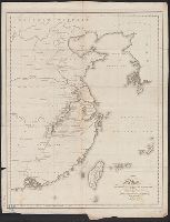
- Beinecke Rare Book and Manuscript Library > The Regent's Sword Peninsula.
- Published / Created:
- 1809
- Call Number:
- 56 1809
- Container / Volume:
- BRBL_00295
- Image Count:
- 1
- Resource Type:
- Maps, Atlases & Globes
- Found in:
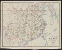
- Beinecke Rare Book and Manuscript Library > China. Neele Sculpt.
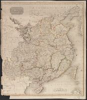
- Creator:
- Cary, John, ca. 1754-1835
- Published / Created:
- Apr. 28, 1811.
- Call Number:
- 56 1811
- Container / Volume:
- BRBL_00685
- Image Count:
- 1
- Resource Type:
- Maps, Atlases & Globes
- Found in:
- Beinecke Rare Book and Manuscript Library > A new map of China, from the latest authorities / by John Cary, engraver.
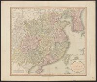
- Creator:
- Cary, John, ca. 1754-1835
- Published / Created:
- Apr. 28, 1811.
- Call Number:
- 56 1811
- Container / Volume:
- BRBL_00295
- Image Count:
- 1
- Resource Type:
- Maps, Atlases & Globes
- Found in:
- Beinecke Rare Book and Manuscript Library > A new map of China, from the latest authorities / by John Cary, engraver.
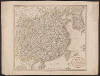
- Published / Created:
- 1816
- Call Number:
- 56 1816
- Container / Volume:
- BRBL_00295
- Image Count:
- 1
- Resource Type:
- Maps, Atlases & Globes
- Found in:
- Beinecke Rare Book and Manuscript Library > A map of the Route of the British Embassy, from the mouth of the Peiho River, to Pekin and from thence to Canton, in the year 1816.
- Published / Created:
- [1848?]
- Call Number:
- 56 1848
- Container / Volume:
- BRBL_00295
- Image Count:
- 1
- Resource Type:
- Maps, Atlases & Globes
- Found in:
- Beinecke Rare Book and Manuscript Library > Map of China ...
- Published / Created:
- 1859
- Call Number:
- 56cea 1841
- Container / Volume:
- BRBL_00298
- Image Count:
- 1
- Resource Type:
- Maps, Atlases & Globes
- Found in:
- Beinecke Rare Book and Manuscript Library > China. Bashee and Ballingtang Channels. J. & C. Walker, Sculpt.
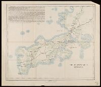
- Creator:
- United States. Adjutant-General's Office. Military Information Division
- Published / Created:
- 1900
- Call Number:
- 56 1900
- Container / Volume:
- BRBL_00296
- Image Count:
- 1
- Resource Type:
- Maps, Atlases & Globes
- Found in:
- Beinecke Rare Book and Manuscript Library > Map of north eastern China / prepared in the War Department, Adjutant General's Office, Military Information Division.
- Creator:
- Rand McNally and Company
- Published / Created:
- c1901.
- Call Number:
- 56 1901A
- Container / Volume:
- BRBL_00296
- Image Count:
- 2
- Resource Type:
- Maps, Atlases & Globes
- Found in:
- Beinecke Rare Book and Manuscript Library > A new map of the Chinese Empire with Japan and Korea. Map of Asia. / by Rand, McNally & Co.
- Creator:
- United States. Hydrographic Office
- Published / Created:
- 1904
- Call Number:
- 57 1904
- Container / Volume:
- BRBL_00302
- Image Count:
- 1
- Resource Type:
- Maps, Atlases & Globes
- Found in:
- Beinecke Rare Book and Manuscript Library > Asia, Japan and Korea : with the surrounding seas and the adjacent coastal region of China / published at Washington, D.C. Feb. 1904, at the Hydrographic Office. H.M. Hodges, Lieutenant Commander, U.S.N. Hydrographer.