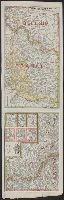
Western battle front no. 1, Nieuport to Reims and Western battle front, Reims, France to Basel, Switzerland
Description:
Includes 3 insets: Russo-German war front -- [Franco-German border] -- Pozieres and environs., Includes advertisement for First and old Detroit national bank., Includes ill. of military figures, places, soldiers, etc. with captions., and Shows boundaries, roads,
Publisher:
Geographical Publishing Co.,
Subject (Geographic):
Europe--Maps, France--Maps, Germany--Maps, Poland--Maps, and Russia--Maps
Subject (Topic):
World War, 1914-1918--Europe--Maps, World War, 1914-1918--France--Maps, World War, 1914-1918--Germany--Maps, World War, 1914-1918--Poland--Maps, and World War, 1914-1918--Russia--Maps
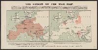
Compares the amount of territory occupied by the Allies versus that of the Central Powers., In lower margin: "If it is indeed true that the map is the test of Germany's success, then Germany has already irrevocably lost the war.", and Includes additional text.
Publisher:
Stanford's Geogl. Estabt.,
Subject (Geographic):
Europe--Administrative and political divisions--History--20th century--Maps, Europe--Maps, Germany--Administrative and political divisions--History--20th century--Maps, and Germany--Maps
Subject (Topic):
World War, 1914-1918--Europe--Maps and World War, 1914-1918--Germany--Maps
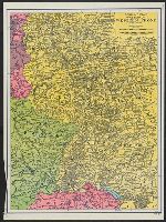
"Reproduced, Army Service Schools, Fort Leavenworth Kas." and Shows France, Germany, Belgium, and Luxembourg including state boundaries, cities, roads, railroads, rivers, canals, fortified towns, forts, woods, forests, etc.
Publisher:
Army Service Schools,
Subject (Geographic):
Belgium--Maps, France--Maps, and Germany--Maps
Subject (Topic):
World War, 1914-1918--Campaigns--Europe--Maps and World War, 1914-1918--Europe--Maps