Skip to search
Skip to main content
Skip to first result
Search
You Searched For
Language
English
Subject (Geographic)
Tyrol (Austria)--Maps
New Search
Search Results
Published / Created:
1918
Call Number:
428gm 1918
Container / Volume:
BRBL_00249
Image Count:
1
Resource Type:
Maps, Atlases & Globes
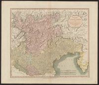
Description:
"From 2nd corrected edition of the map compiled by J. Georg Thoni, printed by K. Redlich Innsbruch, and published by J. Grissmann." and In lower margin: "G.S.G.S. 3702 ; Ordnance Survey, November 1918. Additions, December [1918]."
Publisher:
G.S.G.S.,
Subject (Geographic):
Liechtenstein--Maps, Tyrol (Austria)--Maps, and Vorarlberg (Austria)--Maps
Found in:
Beinecke Rare Book and Manuscript Library > Route map of Tirol, Vorarlberg and Liechtenstein giving distances.
Published / Created:
191-.
Call Number:
11hcf 1919D-2
Container / Volume:
BRBL_00010W
Image Count:
1
Resource Type:
Maps, Atlases & Globes
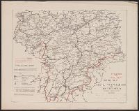
Description:
Shows Tyrol region.
Publisher:
s.n.,
Subject (Geographic):
Tyrol (Austria)--Maps
Found in:
Beinecke Rare Book and Manuscript Library > Tyrol.
Published / Created:
191-.
Call Number:
11hcf 1919D-23
Container / Volume:
BRBL_00010W
Image Count:
1
Resource Type:
Maps, Atlases & Globes
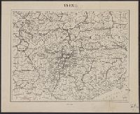
Description:
Shows Tyrol and surrounding region.
Publisher:
s.n.,
Subject (Geographic):
Tyrol (Austria)--Maps
Found in:
Beinecke Rare Book and Manuscript Library > Tyrol.
Branch:v1.61.6 ,Deployed:2024-06-12T09:55:33-04:00