"For Mr. Postlethwayte's Dictionary of trade & commerce.", Includes historical and descriptive notes, and an inset chart of Baffin Bay and Hudson Bay., Plates I-IV., Relief shown pictorially., and Shows provinces, cities and towns, forts, Indian villages and trib
Publisher:
H. Woodfall etc.,
Subject (Geographic):
NorthAmerica--Maps--Early works to
Subject (Name):
Anville, Jean Baptiste Bourguignon d', 1697-1782, Gravelot, H, Postlethwayt, Malachy, 1707?-1767. Universal dictionary of trade and commerce, Seale, Richard William, and Walker, Anthony, 1726-1765
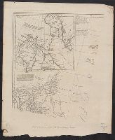
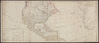
Includes table of "The continent and islands of America are divided and possessed as follows viz." and May be part of a map attributed to R. Sayer, based on maps by d'Anville and materials by Thomas Pownall; first issued in 1763 by J. Gibson and reissued over
Publisher:
s.n.,
Subject (Geographic):
NorthAmerica--Maps--Early works to
Subject (Name):
Anville, Jean Baptiste Bourguignon d', 1697-1782, Gibson, J. (John), and Pownall, Thomas, 1722-1805
Includes table of "The continent and islands of America are divided and possessed as follows viz.", Prime meridian: Ferro., and Probably part of a map attributed to R. Sayer, based on maps by d'Anville and materials by Thomas Pownall; first issued in 1763 by J.
Publisher:
s.n.,
Subject (Geographic):
NorthAmerica--Maps--Early works to
Subject (Name):
Anville, Jean Baptiste Bourguignon d', 1697-1782, Gibson, J. (John), and Pownall, Thomas, 1722-1805
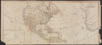
Appears in various eds. of Atlas geographicus maior., Includes German text relating to English and French territorial claims., Neat lines measures 45.8 x 50.8 cm. on sheet 50 x 57.5 cm. Ms. note on verso: No. 151, Nord America nach d'Anville. Franklin Collection no. 131 1756-9., Place names and descriptive notes in English., Prime meridian: Ferro and London., and Relief shown pictorially.
Publisher:
[Homann Erben],
Subject (Geographic):
NorthAmerica--Maps--Early works to
Subject (Name):
Anville, Jean Baptiste Bourguignon d', 1697-1782 and Homann Erben (Firm). Atlas geographicus maior
755 1756E: Mounted on paper. Neat line measures 45.9 x 51 cm. on sheet 46 x 51.2 cm. Ms. no.: 54., Includes German text relating to English and French territorial claims., Prime meridian: Ferro and London., Relief sh, and Sheet measures 49.5 x 57.2 cm.
Publisher:
[Homann Erben],
Subject (Geographic):
NorthAmerica--Maps--Early works to
Subject (Name):
Anville, Jean Baptiste Bourguignon d', 1697-1782 and Homann Erben (Firm). Atlas geographicus maior
Appears in various eds. of Atlas geographicus maior., Includes German text relating to English and French territorial claims., Mounted on paper. Neat line measures 45.9 x 51 cm. on sheet 46 x 51.2 cm. Ms. no.: 54., and Place names and descriptive notes in Englis
Publisher:
[Homann Erben],
Subject (Geographic):
NorthAmerica--Maps--Early works to
Subject (Name):
Anville, Jean Baptiste Bourguignon d', 1697-1782 and Homann Erben (Firm). Atlas geographicus maior
Appears in various eds. of Atlas geographicus maior., Includes German text relating to English and French territorial claims., Place names and descriptive notes in English., Prime meridian: Ferro and London., Relief shown pictorially., and Sheet measures 47.1 x 52 cm. Ms. no. on verso: No. 5. Cross Collection no. 194.
Publisher:
[Homann Erben],
Subject (Geographic):
NorthAmerica--Maps--Early works to
Subject (Name):
Anville, Jean Baptiste Bourguignon d', 1697-1782 and Homann Erben (Firm). Atlas geographicus maior
Appears in various eds. of Atlas geographicus maior., Includes German text relating to English and French territorial claims., Place names and descriptive notes in English., Prime meridian: Ferro and London., Relief shown pictorially., and Sheet measures 49.5 x 61.7 cm. Title in ms. on verso. Franklin Collection no. 131 1777-1.
Publisher:
[s.n.],
Subject (Geographic):
NorthAmerica--Maps--Early works to
Subject (Name):
Anville, Jean Baptiste Bourguignon d', 1697-1782 and Homann Erben (Firm). Atlas geographicus maior