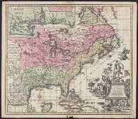
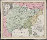
Appears in the author's Grosser atlas ... [between 1734 and 1750?], Covers North America from Quebec to the Gulf of Mexico, and to New Mexico in the west., In French, with title in Latin., and Includes decorative cartouche, historical notes and inset of "Les cos
Includes ill. of natives in upper left and right., Relief shown pictorially., Some French notes., and Yale's copy annotated in ink in upper right margin: Nr073.
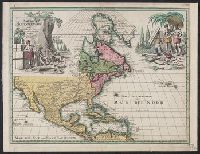
Nova mappa geographica Americae Septentrionalis in suas praecipuas partes divisa
Description:
In French, with alternate title in Latin., Includes 18 insets and decorative cartouche., Prime meridians: Ferro and Paris., Relief shown pictorially., Title from upper margin., and Yale copy stamped on verso: Yale, Horace Brown, 1900S.
Publisher:
Sumptibus Ioh. Mich. Probst,
Subject (Geographic):
NorthAmerica--Maps--Early works to
Subject (Name):
Popple, Henry, -1743. Map of the British Empire in America and Probst, Jean George
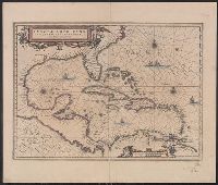
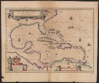
Insulae Americanae in Oceano Septentrionali cum terris adjacentibus and Insvlae Americanae in Oceano Septentrionali cum terris adiacentibus
Description:
Cf. Burden, P.D. Mapping of North America, 242., Cf. Koeman, C. Atlantes Neerlandici (1997 ed.), II, p. 600 (map 9600:2B)., Includes dedication to "D. Alberto Conradi Vander Burch" signed "tabulam hanc inscribit Guiljelmus Blaeu.", Includes embellished title cartouche, dedication with coats-of-arms, scale and ill. of ships at sea., and Includes scales in milliaria germanica and milliaria hispanica.
Publisher:
s.n.,
Subject (Geographic):
Caribbean Area--Maps--Early works to 1800, Mexico, Gulf of--Maps--Early works to 1800, and West Indies--Maps--Early works to 1800
Insulae Americanae in Oceano Septentrionali cum terris adjacentibus and Insvlae Americanae in Oceano Septentrionali cum terris adiacentibus
Description:
Appears in various French eds. of Jansson's Nouvel atlas., Includes embellished title cartouche, dedication with coat, Includes scales in milliaria germanica and milliaria hispanica., and Mounted on linen. Sheet measures 49.8 x 58.6 cm. Cross Collection no. 233.
Publisher:
Apud Ioannem Ianssonium,
Subject (Geographic):
Caribbean Area--Maps--Early works to 1800, Mexico, Gulf of--Maps--Early works to 1800, and West Indies--Maps--Early works to 1800
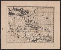
Insulae Americanae in Oceano Septentrionali cum terris adjacentibus
Description:
An unrecorded reduced version of Blaeu's map, where the cherub decorations on the cartouche and scale have been replaced by Native Americans, West Indians and Europeans. Coastlines vary sligh and Includes scales in milliaria germanica and milliaria hispanica.
Publisher:
s.n.,
Subject (Geographic):
Caribbean Area--Maps--Early works to 1800, Mexico, Gulf of--Maps--Early works to 1800, and West Indies--Maps--Early works to 1800
Insulae Americanae in Oceano Septentrionali cum terris adjacentibus and Insvlae Americanae in Oceano Septentrionali cum terris adiacentibus
Description:
From Willem Janszoon and Joan Blaeu's Theatrum orbis terrarum ... Amsterdami : Apud Guiljelmum et Iohannem Blaeu, 1635., Includes dedication to "D. Alberto Conradi Vander Burch" signed "tabulam hanc inscribit Guiljelmus Blaeu.", Includes embellished title cartouche, dedication with coats-of-arms, scale and ill. of ships at sea., and Includes scales in milliaria germanica and milliaria hispanica.
Publisher:
s.n.,
Subject (Geographic):
Caribbean Area--Maps--Early works to 1800, Mexico, Gulf of--Maps--Early works to 1800, and West Indies--Maps--Early works to 1800
Subject (Name):
Blaeu, Joan, 1596-1673. Theatrum orbis terrarum and Blaeu, Willem Janszoon, 1571-1638. Theatrum orbis terrarum
Appears in Homann Erben's Atlas geographicus major [1759 or 1763?]., Includes ill. and text., Relief shown pictorially., Some text in French., and Yale's card catalog notes "Fock catalogue no. 731 (fr. wh. acquired) gives date as ca. 1730"; and "In Homann J.B. Ne
Publisher:
[Homannianis heredibus?,
Subject (Geographic):
NorthAmerica--Maps--Early works to
Subject (Name):
Hennepin, Louis, 17th cent and Homann Erben (Firm). Atlas geographicvs maior
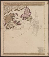
Carte nouvelle contenant la partie d'Amerique la plus septentrionale : ou sont exactement dêcrites les provinces suivantes comme le Canada ou Nouvelle France, la Nouvelle Ecosse, la Nouvelle Angleterre, les Nouveaux Paı̈s Bas, la Pensylvanie, la Virginie
Description:
"Cum privilegio ordinum generalium foederati Belgii.", Appears in some eds. of the author's Atlas minor sive geographia compendiosa., Library copy incomplete, Atlantic Canada sheet only; damaged in upper left., and Relief shown pictorially. Depths shown by sound
Publisher:
Nicolao Visscher,
Subject (Geographic):
NorthAmerica--Maps--Early works to
Subject (Name):
Anse, Luggert van, fl. 1690-1716, engraver and Visscher, Nicolaes, 1649-1702. Atlas minor sive geographia compendiosa