Skip to search
Skip to main content
Skip to first result
Search
You Searched For
Date
1938 - 1939
Repository
Beinecke Rare Book and Manuscript Library
Resource Type
Maps, Atlases & Globes
Language
French
Date Created
1938 to 1939
New Search
Search Results
Creator:
Published / Created:
19--?]
Call Number:
71 1683
Container / Volume:
BRBL_00360
Image Count:
1
Resource Type:
Maps, Atlases & Globes
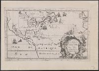
Description:
Photocopy of map from Hennepin's Description de la Louisiane. Paris, 1683. and Relief shown pictorially.
Publisher:
s.n.,
Subject (Geographic):
North America--Maps
Subject (Name):
Guérard, Nicholas and Hennepin, Louis, 17th cent. Description de la Louisiane, nouvellement decouverte au sud' oüest de la Nouvelle France, par ordre du roy
Found in:
Beinecke Rare Book and Manuscript Library > Carte de la Nouvelle France : et de la Louisiane nouvellement decouverte dediee au roy l'an 1683 / par le Reverend Pere Louis Hennepin, missionaire recollect et notaire apostoliquen ; N.Guerard ... et fecit.
Published / Created:
[19--?]
Call Number:
38ag P21 1920
Container / Volume:
BRBL_00167
Image Count:
2
Resource Type:
Maps, Atlases & Globes
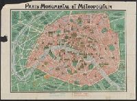
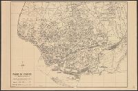
Alternative Title:
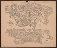
Paris et ses environs
Description:
Ancillary map of Paris and environs on verso. Some buildings and sites shown pictorially. and Buildings and sites shown pictorially.
Publisher:
F. Dutal & Co. Imp.,
Subject (Geographic):
Paris (France)--Maps and Paris Region (France)--Maps
Subject (Topic):
Historic buildings--France--Paris--Maps and Monuments--France--Paris--Maps
Found in:
Beinecke Rare Book and Manuscript Library > Paris monumental and métropolitain [cartographic material].
Creator:
Published / Created:
[between 1920 and 1940?]
Call Number:
400 R66 1920
Container / Volume:
BRBL_00233
Image Count:
1
Resource Type:
Maps, Atlases & Globes
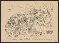
Description:
Map and aerial view of Rome., Oriented with north to the lower right., and Relief shown by hachures and pictorially.
Publisher:
[publisher not identified],
Subject (Geographic):
Rome (Italy)--Antiquities--Maps, Rome (Italy)--Antiquities--Pictorial works, Rome (Italy)--Maps, and Rome (Italy)--Pictorial works
Subject (Topic):
Geography, Ancient--Maps
Found in:
Beinecke Rare Book and Manuscript Library > Rome imperiale (IVe siècle ap. J.C.) / par P. Bigot.
Published / Created:
19--?]
Call Number:
11hcf 1919-8
Container / Volume:
BRBL_00010M
Image Count:
2
Resource Type:
Maps, Atlases & Globes
Alternative Title:
Distribution of forces in Russia
Description:
Map page from Atlas VIDAL-LABLACHE. Shows "Allied forces in black. Bolshevist forces in blue" with corresponding ms. notes on map. Ms. notes detail nationalities and commanders of individual forces and their placement. Map text in French, ms. notes in Eng
Publisher:
A. Colin,
Subject (Geographic):
Russia--Maps
Found in:
Beinecke Rare Book and Manuscript Library > [Russie Carte Politique.]
Branch:v1.61.6 ,Deployed:2024-06-12T09:55:19-04:00