Skip to search
Skip to main content
Skip to first result
Search
You Searched For
Date
-
"United States--Maps"
Access
Public
Language
French
New Search
Search Results
Creator:
United States . Army Map Service
Published / Created:
1943
Call Number:
38 C71 1943
Container / Volume:
BRBL_00157
Image Count:
1
Resource Type:
Maps, Atlases & Globes
Alternative Title:
France 1:15,000 and Series M961
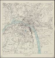
Description:
"3-43.", "Copied from French map, 1:50,000, Colmar F 37-18, revised to 1926.", "First edition 1943.", A few buildings are named., Military grid., Place names and buildings in French., and Relief show by spot heights.
Publisher:
Army Map Service,
Subject (Geographic):
Colmar (France)--Maps
Found in:
Beinecke Rare Book and Manuscript Library > Colmar [cartographic material] : city plan / prepared under the direction of the Chief of Engineers, U.S. Army, 1943.
Creator:
United States . Army Map Service
Published / Created:
1943
Call Number:
38 R75 1943
Container / Volume:
BRBL_00165
Image Count:
1
Resource Type:
Maps, Atlases & Globes
Alternative Title:
France 1:12,500 and Series M961
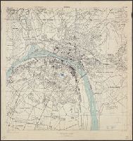
Description:
"3-43.", "Copied from a French map, 1:10,000, Plan de la ville de Rouen, 1933.", "First edition 1943.", Most streets and some buildings are named., Nord de guerre zone grid., and Street names and some points of interest in French.
Publisher:
Army Map Service, U.S. Army,
Subject (Geographic):
Rouen (France)--Maps
Found in:
Beinecke Rare Book and Manuscript Library > Rouen, city plan [cartographic material] / prepared under the direction of the Chief of Engineers, U.S. Army, 1943.
Creator:
United States . Army Map Service
Published / Created:
1943
Call Number:
38 R75 1943
Container / Volume:
BRBL_00165
Image Count:
1
Resource Type:
Maps, Atlases & Globes
Alternative Title:
France 1:12,500 and Series M961
Description:
"3-43.", "Copied from a French map, 1:10,000, Plan de la ville de Rouen, 1933.", "First edition 1943.", Most streets and some buildings are named., Nord de guerre zone grid., and Street names and some points of interest in French.
Publisher:
Army Map Service, U.S. Army,
Subject (Geographic):
Rouen (France)--Maps
Found in:
Beinecke Rare Book and Manuscript Library > Rouen, city plan [cartographic material] / prepared under the direction of the Chief of Engineers, U.S. Army, 1943.
Creator:
United States . Army Map Service
Published / Created:
1943
Call Number:
38 Sa24 1943
Container / Volume:
BRBL_00165
Image Count:
1
Resource Type:
Maps, Atlases & Globes
Alternative Title:
France 1:5,000, Saint Nazaire, and Series M961
Description:
"4-43.", "Copied from CB 1804, map 27.", "French Lambert zone II grid.", Major street names and place names in French., Relief shown by rock drawings., and Some streets and buildings are named.
Publisher:
Army Map Service, U.S. Army,
Subject (Geographic):
Saint-Nazaire (France)--Maps
Found in:
Beinecke Rare Book and Manuscript Library > St. Nazaire, city plan [cartographic material] / prepared under the direction of the Chief of Engineers, U.S. Army, Washington, D.C.
Published / Created:
1820
Call Number:
75 1820B
Container / Volume:
BRBL_00397
Image Count:
1
Resource Type:
Maps, Atlases & Globes
Description:
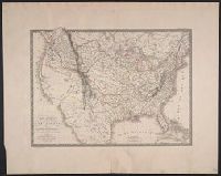
Atlas Universal Pl. 34. and Preliminary record.
Publisher:
Chez l'Auteur,
Subject (Geographic):
United States --Maps
Found in:
Beinecke Rare Book and Manuscript Library > Carte Generale des États-Unis ... par A.H. Brué Geographe ... Gravée Sous la direction de Auteur.
Published / Created:
1825
Call Number:
75 1825
Container / Volume:
BRBL_00398
Image Count:
1
Resource Type:
Maps, Atlases & Globes
Publisher:
L'Auteur,
Subject (Geographic):
United States --Maps
Found in:
Beinecke Rare Book and Manuscript Library > Carte Generale des États-Unis, du Canada ... par A. Brué, Géographe du Roi. Gravée sous la direction de l'Auteur.
Published / Created:
1825
Call Number:
75J 1825
Container / Volume:
BRBL_00414A
Image Count:
1
Resource Type:
Maps, Atlases & Globes
Subject (Geographic):
United States --Maps
Found in:
Beinecke Rare Book and Manuscript Library > Carte de l'adjonction progressive des divers états au territoire et à l'union constitutionnelle des Etats-Unis de L'Amerique du Nord.
Published / Created:
[1812?]
Call Number:
75 1812B
Container / Volume:
BRBL_00396
Image Count:
1
Resource Type:
Maps, Atlases & Globes
Subject (Geographic):
United States --Maps
Found in:
Beinecke Rare Book and Manuscript Library > Etats Unis et Grandes Antilles. Gravé par Chamouin Rue de la Harpe. No. 35. Ecrit par Giraldon.
Published / Created:
1918
Call Number:
38 V664 1918
Container / Volume:
BRBL_00167
Image Count:
1
Resource Type:
Maps, Atlases & Globes
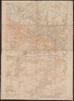
Description:
"Groupe de Ganevas de Tir ; 27 Julliet 1918 ; secret"., Pencil and color annotations on printed base map., Relief shown by contours and spot heights., and Shows infantry routes, roads not to be used by infantry, and objectives.
Publisher:
s.n.],
Subject (Geographic):
Picardy (France)--Maps
Subject (Name):
United States.--Army.--Division, 32nd--Maps
Subject (Topic):
histories--United States --Maps
Found in:
Beinecke Rare Book and Manuscript Library > Vic-Sur-Aisne [cartographic material].
Creator:
Published / Created:
1784
Call Number:
75 1784J
Container / Volume:
BRBL_00396
Image Count:
1
Resource Type:
Maps, Atlases & Globes
Description:
Includes notes, index to forts, and "Tableau ... de la population des Etats-Unis ... ", Local copy has no date following "confirmées par le traité définitif.", Prime meridians: Paris and Ferro., and Relief shown pictorially.
Publisher:
Chez Esnauts et Rapilly,
Subject (Geographic):
United States --Maps --Early works to
Subject (Name):
Esnauts et Rapilly, Paris
Found in:
Beinecke Rare Book and Manuscript Library > Carte des Etats-Unis d'Amérique, et du cours du Mississippi; rédigée d'après différentes cartes et relations anglaises et les opérations de la derniere guerre; avec les nouvelles limites générales fixées par les articles préliminaires de paix, s
Branch:v1.61.8 ,Deployed:2024-06-20T11:14:55-04:00