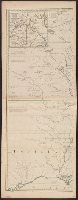
4th impression of 3d French ed. Cf. Ristow, W.W. A la carte, p. 112., Includes text and inset "Nouvelle carte de la baye d'Hudson et de Labrador selon les dernieres cartes levées sur les lieux.", Prime meridian: London., Relief shown pictorially., and Title in F
Publisher:
Le Rouge?,
Subject (Geographic):
NorthAmerica--Maps--Early works to
Subject (Name):
Hawkins, M., fl. 1776-1792 and Le Rouge, Georges-Louis
Gussefeld, F. L. (Franz Ludwig), 1744-1807 Homann Erben (Firm) Schmidt, I. M.
Published / Created:
ao. 1784
Call Number:
1983 Folio 23
Collection Title:
[Atlas factice of 50 maps, primarily by Johann Baptist Homann and/or issued by the Homann Erben
Image Count:
1
Alternative Title:
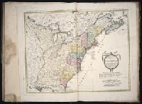
Treize Etats Unis de l'Amerique septentrionale, d'apress les meilleurs & speciales cartes angloises qui ont parues jusqu'ici and XIII Etats Unis de l'Amerique septentrionale, d'apress les meilleurs & speciales cartes angloises qui ont parues jusqu'ici
Treize Etats Unis de l'Amerique septentrionale, d'apress les meilleurs & speciales cartes angloises qui ont parues jusqu'ici and XIII Etats Unis de l'Amerique septentrionale, d'apres les meilleurs & speciales cartes angloises qui ont parues jusqu'ici
Description:
"I.M. Schmidt, sc. Nor.", "Mit Römisch Kaÿserl. Allerg. Freÿheit.", Backed with linen., Bar scales given in "Geographische Meilen," "See-Meilen 20 auf einen Grad.," and "Englaendil. Meilen.", Prime meridian: Ferro., and Relief shown pictorially.
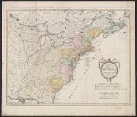
Treize Etats Unis de l'Amerique septentrionale, d'apress les meilleurs & speciales cartes angloises qui ont parues jusqu'ici and XIII Etats Unis de l'Amerique septentrionale, d'apres les meilleurs & speciales cartes angloises qui ont parues jusqu'ici
Description:
"I.M. Schmidt, sc. Nor.", "Mit Römisch Kaÿserl. Allerg. Freÿheit.", Bar scales given in "Geographische Meilen," "See-Meilen 20 auf einen Grad.," and "Englaendil. Meilen.", and Franklin Collection no. 131 1784-7. Sheet measures 54.5 x 67.1 cm.
In bottom margin: gestochen von Carl Jäck Berlin 1791., Includes inset of "Maasstab von Hundert Seemeilen ....", and Relief shown pictorially and by hachures.
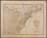
Appears in various eds. of Atlas geographicus maior., Includes German text relating to English and French territorial claims., Neat lines measures 45.8 x 50.8 cm. on sheet 50 x 57.5 cm. Ms. note on verso: No. 151, Nord America nach d'Anville. Franklin Collection no. 131 1756-9., Place names and descriptive notes in English., Prime meridian: Ferro and London., and Relief shown pictorially.
Publisher:
[Homann Erben],
Subject (Geographic):
NorthAmerica--Maps--Early works to
Subject (Name):
Anville, Jean Baptiste Bourguignon d', 1697-1782 and Homann Erben (Firm). Atlas geographicus maior
Appears in various eds. of Atlas geographicus maior., Includes German text relating to English and French territorial claims., Place names and descriptive notes in English., Prime meridian: Ferro and London., Relief shown pictorially., and Sheet measures 47.5 x 51 cm.
Publisher:
[Homann Erben],
Subject (Geographic):
NorthAmerica--Maps--Early works to
Subject (Name):
Anville, Jean Baptiste Bourguignon d', 1697-1782. and Homann Erben (Firm). Atlas geographicus maior.