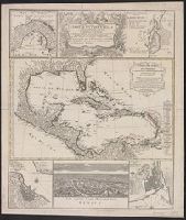
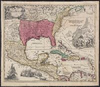
Carte de isles de l'Amérique, Delineatio munimenti et portus S. Augustini, Delineatio portus mexicani Vera Cruz, Technographia urbis San-Domingo, and Urbs capitalis regni mexicani dicta Mexico
Description:
Central map (Carte des isles de l'Amérique). Cross Collection no. 247., Central map has title: Carte des isles de l'Amérique et deplusieurs pays de terre ferme situés au devant de ces isles & autour du Golfe de Mexique / dressée sur un grand nombre de cartes particuliéres ... par le sr. d'Anville, géographe ordre. du roi, mars 1731., Large central map shows southern United States, Mexico, Central America, northern South America, and West Indies. Surrounding maps show the Isthmus of Panama, Saint Augustine, Fla., San Domingo (present-day Haiti), Mexico City, and Vera Cruz, Mexico., Relief shown pictorially., and Surrounding maps have titles: Delineatio munimenti et portus S. Augustini -- Technographia urbis San-Domingo -- Urbs capitalis regni mexicani dicta Mexico -- Delineatio portus mexicani Vera Cruz -- [Isthmus of Panama].
Publisher:
Homann Heirs,
Subject (Geographic):
Caribbean Area--Maps--Early works to 1800, Central America--Maps--Early works to 1800, Haiti--Maps--Early works to 1800, Mexico City (Mexico)--Maps--, and Veracruz (Veracruz-Llave, Mexico)--Maps--Early works to 1800
Subject (Name):
Anville, Jean Baptiste Bourguignon d', 1697-1782. Carte des isles de l'Amérique and Homann Erben (Firm)
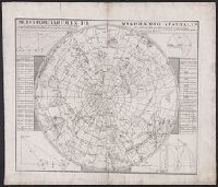
Mappe-monde qui représente les deux hemisphères savoir celui de l'orient et celui de l'occident, tirée des quatre cartes générales de feu M. le profess. Hasius, Planiglobii terrestris mappa vniversalis, and Schul-Atlas von zwantzig General- und Special-Lan
Description:
Appears in Homann heirs' Schul-atlas von zwantzig general-und special-land karten ... Cf. Phillips, no. 293., Imperfect: torn along fold, with no loss of text. Shee, Map colored to show distribution of religions., and Title in Latin and French; legend in German.
Publisher:
Homann Erben],
Subject (Name):
Hase, Johann Matthias, 1684-1742 and Homann Erben (Firm)
Subject (Topic):
Religion--Maps--Early works to 1800 and World maps--Early works to 1800
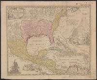
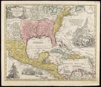
Copy 2: Hand col. Mounted on linen. Sheet measures 52.1 x 59.8 cm., Includes notes and ill., Relief shown pictorially., and Some references suggest earlier possible imprint date.
Publisher:
[Homann Erben?,
Subject (Geographic):
New Spain--Maps--Early works to 1800 and North America--Maps--Early works to 1800
Appears in Homann's Atlas geographicus major ... Normibergae : Curantibus Homannianis heredibus, 1759., Includes notes, ill. of ships in battle, and of Europeans and Native Americans, and four bar scales., Ms. annotations. Ms. no. on verso: 207 III 59. Sheet measures 53.6 x 64.9 cm. Franklin Collection no. 131 1737-2., Relief shown pictorially., Some references suggest earlier possible imprint date., and This edition is at least the second state, as Ludoviciana has replaced Florida as the name of the Louisiana territory.
Publisher:
[Homann Erben?,
Subject (Geographic):
New Spain--Maps--Early works to 1800 and North America--Maps--Early works to 1800
Subject (Name):
Homann Erben (Firm) and Homann, Johann Baptist, 1663-1724. Atlas geographicus major
Appears in Homann's Atlas geographicus major ... Normibergae : Curantibus Homannianis heredibus, 1759., Copy 2: Watermark. Manuscript number on verso, "28." Sheet measures 53 x 61 cm. Cross Collection no. 237., Includes notes, ill. of ships in battle, and of Europeans and Native Americans, and four bar scales., Relief shown pictorially., Some references suggest earlier possible imprint date., and This edition is at least the second state, as Ludoviciana has replaced Florida as the name of the Louisiana territory.
Publisher:
[Homann Erben?,
Subject (Geographic):
New Spain--Maps--Early works to 1800. and North America--Maps--Early works to 1800.
Subject (Name):
Homann Erben (Firm) and Homann, Johann Baptist, 1663-1724. Atlas geographicus major.
Appears in Homann's Atlas geographicus major ... Normibergae : Curantibus Homannianis heredibus, 1759., Copy 1: Ms. no. on verso: 107. Stamp on verso: Yale, Horace Brown, 1900S. Neat line measures 47.6 x 57.5 on sheet 52 x 62 cm., and Includes notes, ill. of sh
Publisher:
[Homann Erben?,
Subject (Geographic):
New Spain--Maps--Early works to 1800 and North America--Maps--Early works to 1800
Subject (Name):
Homann Erben (Firm) and Homann, Johann Baptist, 1663-1724. Atlas geographicus major
Carte general d ́Espagne et de Portugal diviseé en ses provinces actuelles par D.T. Lopez, nouvellement dressée par F.L.G. à Nuremberg chez les Heret. de Homann l ́an 1782
Description:
Bar scales given in "leguas de una hora de Camino," "leguas legales Castellanas," "leguas legales de Portugal," "leguas comunes de Francia," and "leguas geographicas ò de Alemania."
Publisher:
Edentibus Homannianis Haeredibus,
Subject (Geographic):
Portugal--Maps--Early works to 1800 and Spain--Maps--Early works to 1800
Subject (Name):
Güssefeld, F. L. (Franz Ludwig), 1744-1807 and Homann Erben (Firm)
Carte generale de la Tartarie chinoise et des royaumes de Corée et de Iapan
Description:
French alternate title only., Imperfect: western sheet (with cartouche) wanting. Sheet measures 54 x 54 cm, with watermark., Includes text and ill., and Relief shown pictorially.
Publisher:
Curis Homannianorum Heredum,
Subject (Geographic):
Chine--Divisions politiques et administratives--Cartes--Ouvrages avant 1800. and Manchuria (China)--Maps--Early works to 1800.
Subject (Name):
Anville, Jean Baptiste Bourguignon d', 1697-1782., Du Halde, J.-B. (Jean-Baptiste), 1674-1743., Gerbillon, Jean-François, 1654-1707., Homann Erben (Firm), and Mayer, Tobias, 1723-1762.