Skip to search
Skip to main content
Skip to first result
Search
You Searched For
Language
Latin
Subject Heading
Benelux countries > Maps > Early works to 1800
Search Results
Creator:
Published / Created:
1748.
Call Number:
1973 Folio 30
Image Count:
2
Alternative Title:
Carte des XVII. provinces ou de l'Allemagne inferievre, dresseé suivant la projection stereographique, et appüyée par les mesures faites de Mess. Cassini, Snellius et Mouschenbrok, par Mr. Tob. Majer de la Societé geographique, et publiée par les Heritiers de Homann, l'An 1748
Description:
BEIN 1973 Folio 30: Sheet measures 53.9 x 61.8 cm. No. 9 of 32 maps bound together.
Publisher:
Cura et Studio Homannianorum Heredum
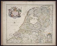
Subject (Geographic):
Benelux countries
Found in:
Beinecke Rare Book and Manuscript Library > Belgii universi seu inferioris Germaniae quam XVII provinciae Austriaco Gallico et Batavo sceptro parentes constituunt nova tabula geographica
Creator:
Published / Created:
1747 [i.e. 1748?]
Call Number:
1975 Folio 31
Image Count:
1
Alternative Title:
Carte des XVII. provinces ou de l'Allemagne inferievre, dresseé suivant la projection stereographique, et appüyée par les mesures faites de Mess. Cassini, Snellius et Mouschenbrok, par Mr. Tob. Majer de la Societé geographique, et publiée par les Heritiers de Homann, l'An 1748
Description:
BEIN 1975 Folio 31: Sheet measures 53.3 x 61 cm. No. 11 of 42 maps bound together.
Publisher:
Cura et Studio Homannianorum Heredum
Subject (Geographic):
Benelux countries, Netherlands, Belgium, and Luxembourg
Found in:
Beinecke Rare Book and Manuscript Library > Belgii universi seu inferioris Germaniae quam XVII provinciae Austriaco Gallico et Batavo sceptro parentes constituunt nova tabula geographica
Creator:
Published / Created:
ca. 1684]
Call Number:
Folio 469
Image Count:
1
Description:
BEIN Folio 469: Sheets measures 52.6 x 61.5 cm. No. 4 of 13 maps bound together with binder's title: Sanson.
Publisher:
Nicolaes Visscher
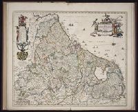
Subject (Geographic):
Benelux countries
Found in:
Beinecke Rare Book and Manuscript Library > Belgium Foederatum [cartographic material]
Creator:
Published / Created:
[ca. 1684]
Call Number:
Folio 469
Image Count:
1
Alternative Title:
Novissima et accuratissima septendecim provinciarum Germanæ Inferiores delineatio
Description:
BEIN Folio 469: Sheets measures 52.7 x 61.3 cm. No. 3 of 13 maps bound together with binder's title: Sanson.
Publisher:
Ex officina Nicolaes Visscher ...
Subject (Geographic):
Benelux countries
Found in:
Beinecke Rare Book and Manuscript Library > Novissima et accuratissima XVII provinciarum Germanæ Inferiores delineatio [cartographic material].
Creator:
Published / Created:
1704.
Call Number:
1973 Folio 18
Image Count:
1
Description:
BEIN 1973 Folio 18: Backed with paper. Ms. no. "38" in upper-right corner. Sheet measures 53.7 x 62.4 cm. No. 37 of 87 maps bound together.
Publisher:
Peter Schenk
Subject (Geographic):
Benelux countries
Subject (Topic):
Maps
Found in:
Beinecke Rare Book and Manuscript Library > Septendecim provinciae Germaniae inferioris uti sunt sub potestate regum Franciae, et Hispaniae, ordinumque generalium provinciarum unitarum , una cum episcopatibus Monasteriensi, Coloniensi, Leodiensi, et Cameracensi : XVII provinciae latae sunt 88 et longae 60 miliaria Gallica, atque una complent 4928 miliaria quadrata, in iis inveniuntur 216 urbes et 6000 pagi / [cartographic material]