Search
You Searched For
Search Results
- Creator:
- Fernandes, José, Cartographer, cartographer.
- Call Number:
- Manuscript 911cea 1789
- Image Count:
- 2
- Resource Type:
- Maps, Atlases & Globes
- Found in:
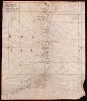
- Beinecke Rare Book and Manuscript Library > Carta reduzida de hua parte de costa do Brasil : desde o Morro de S. Paulo athê Santos / por José Fernandes, Portugal na Bahia de Todos os Santos no Anno de 1789.
- Creator:
- Portugal. Comissão de Cartografia das Colónias, author
- Call Number:
- 6514 1885
- Container / Volume:
- BRBL_00342
- Image Count:
- 1
- Resource Type:
- Maps, Atlases & Globes
- Found in:
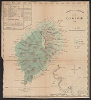
- Beinecke Rare Book and Manuscript Library > Carta da Ilha de S. Thomé / Comissão de Cartographia ; coordenada por Ernesto de Vasconcellos ; desenhada por A. A. d' Oliveira.
- Creator:
- Howell, Alfredo William, cartographer
- Call Number:
- 636 1897
- Container / Volume:
- BRBL_00337
- Image Count:
- 1
- Resource Type:
- Maps, Atlases & Globes
- Found in:
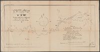
- Beinecke Rare Book and Manuscript Library > Costa oriental d'Africa : provincia de Moçambique reconhecimento hydrographico do Rio Chinde / executado pelo 2o. Tenente da Armada Alfredo Guilherme Howell, Commandante do sapôr "Coama," 1890.
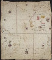
- Creator:
- Aguilar, Jorge de.
- Published / Created:
- no anno dominus nostris Jh[es]u Xpi de 1492.
- Call Number:
- Art Storage 30cea 1492
- Image Count:
- 2
- Resource Type:
- Maps, Atlases & Globes
- Found in:
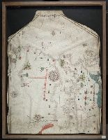
- Beinecke Rare Book and Manuscript Library > Portolan chart of the Mediterranean Sea, the North Atlantic Ocean, the Black Sea, and the West African coast as far south as Sierra Leone.
- Creator:
- Linschoten, Jan Huygen van, 1563-1611
- Published / Created:
- 1596]
- Call Number:
- 64 1596
- Container / Volume:
- BRBL_00337
- Image Count:
- 1
- Resource Type:
- Maps, Atlases & Globes
- Found in:
- Beinecke Rare Book and Manuscript Library > Typus orarum maritimarum Guineae, Manicongo, & Angôlae ultra promontorium Bonae Spei ... [cartographic material] = Afheeldinghe der custen des landts Guinea, Manicongo, ende Angôla, ende voorts tot voorby de C. de boa esperança ... / Arnoldus F. á Lan
- Creator:
- Linschoten, Jan Huygen van, 1563-1611
- Published / Created:
- 1596?]
- Call Number:
- 63 1596
- Container / Volume:
- BRBL_00334
- Image Count:
- 1
- Resource Type:
- Maps, Atlases & Globes
- Found in:
- Beinecke Rare Book and Manuscript Library > Delineatio orarum maritimarum, terrae vulgo indigetatae terra do Natal item Sofalae, Mozambicae & Melindae ... [cartographic material] = Affbeeldinghe der custen des landts genaempt terra do Natal, item van alle de custen van Coffala, Mozambique, Melinde
- Published / Created:
- 1619?]
- Call Number:
- 21cea 1619
- Container / Volume:
- BRBL_00700
- Image Count:
- 1
- Resource Type:
- Maps, Atlases & Globes
- Found in:
- Beinecke Rare Book and Manuscript Library > [Anonymous ms. Portugese portolano of the Atlantic Ocean.]
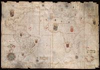
- Creator:
- Albernaz, João Teixeira, active 1665-1681
- Published / Created:
- [1665]
- Call Number:
- 11 1665
- Image Count:
- 2
- Resource Type:
- Maps, Atlases & Globes
- Found in:
- Beinecke Rare Book and Manuscript Library > Portolan chart of the Atlantic, the western half of the Indian Ocean, and the extreme southeast of the Pacific.