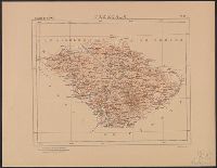
Mexico. Dirección de Estudios Geográficos y Climatológicos
Published / Created:
[1922]
Call Number:
884 1922
Container / Volume:
BRBL_00654
Image Count:
2
Resource Type:
Maps, Atlases & Globes
Alternative Title:
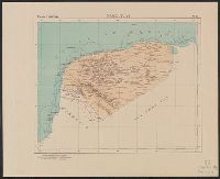
Plano de la ciudad y puerto de Veracruz.
Description:
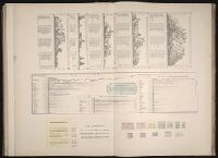
"No. 30.", Accompanied by physiographic plate covering same area, showing only relief and drainage (1 sheet : col. ; 85 cm.)., Appears in Atlas geográfico de la República Mexicana., Inset: Plano de la ciudad y puerto de Veracruz. Scale 1:25,000., and Relief shown by shading. Depths shown by isolines.
Publisher:
El Dirección,
Subject (Geographic):
Veracruz (Veracruz, Mexico)--Maps and Veracruz-Llave (Mexico : State)--Maps
Subject (Name):
Mexico. Dirección de Estudios Geográficos y Climatológicos. Atlas geográfico de la República Mexicana
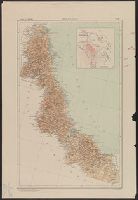
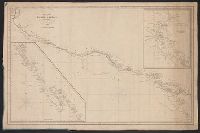
Insets: Harbour of Monterey / surveyed by the officers of the U.S.S. Dale ... 1843. Scale [ca. 1:30,500] -- The Harbour of San Francisco / surveyed by Captn. F.W. Beechey -- [Coast from Port Venderas to San Francisco]. Scale [ca. 1:5,650,000]. and Shows route of "Corvetas Descubierta y Atrevida en 1791."
Publisher:
E. & G.W. Blunt,
Subject (Name):
Beechey, Frederick William, 1796-1856. Harbour of San Francisco
Subject (Topic):
Harbors--California--Monterey--Maps, Naut, Nautical charts--California, Nautical charts--California--Monterey Bay, Nautical charts--California--San Francisco Bay Area, and Nautical charts--Central America
Includes insets of "Harbour of San Francisco, surveyed by Capt. F.W. Beechey" and the west coast from Port Venderas to San Francisco., Relief shown by hachures. Depths shown by soundings., and Shows route of "Corvetas Descubierta y Atrevida en 1791."
Publisher:
E. & G.W. Blunt,
Subject (Name):
Beechey, Frederick William, 1796-1856. Harbour of San Francisco
Subject (Topic):
Harbors--California--Monterey--Maps, Naut, Nautical charts--California, Nautical charts--California--Monterey Bay, Nautical charts--California--San Francisco Bay Area, and Nautical charts--Central America
Mexico. Dirección de Estudios Geográficos y Climatológicos
Published / Created:
[1922]
Call Number:
8894 1922
Container / Volume:
BRBL_00656
Image Count:
2
Resource Type:
Maps, Atlases & Globes
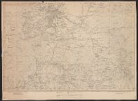
Description:
"No. 31.", Accompanied by physiographic plate covering same area, showing mainly relief and drainage (1 sheet : col. ; 48 cm.)., and Relief shown by shading. Depths by isolines.