Search
You Searched For
Search Results
- Published / Created:
- 1802
- Call Number:
- 9745 1802
- Container / Volume:
- BRBL_00678
- Image Count:
- 1
- Resource Type:
- Maps, Atlases & Globes
- Found in:
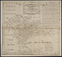
- Beinecke Rare Book and Manuscript Library > Corografia de la Prov. Puno.
- Creator:
- Ringgold, Cadwalader, 1802-1867
- Published / Created:
- [1851?]
- Call Number:
- 844cea Sa52 1850A
- Container / Volume:
- BRBL_00614
- Image Count:
- 1
- Resource Type:
- Maps, Atlases & Globes
- Found in:
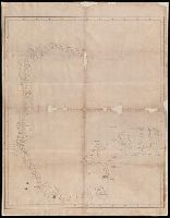
- Beinecke Rare Book and Manuscript Library > Chart of the Farallones and entrance to the bay of San Francisco : California / by Cadwalader Ringgold, Commander, U.S. Navy ; assisted by Simon F. Blunt, Lieut., U.S. Navy, 1850.
- Published / Created:
- [1810?]
- Call Number:
- 28cea M314 1810
- Container / Volume:
- BRBL_00700
- Image Count:
- 1
- Resource Type:
- Maps, Atlases & Globes
- Found in:
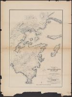
- Beinecke Rare Book and Manuscript Library > [Manuscript map of Manila Harbor and Bay Lake].
- Published / Created:
- [approximately 1780?]
- Call Number:
- 39 M29 1795
- Container / Volume:
- BRBL_00703
- Image Count:
- 1
- Resource Type:
- Maps, Atlases & Globes
- Found in:
- Beinecke Rare Book and Manuscript Library > Plano Dela Plaza y Puerto de Malaga.
- Published / Created:
- 1788
- Call Number:
- 390 No. 9
- Container / Volume:
- BRBL_00703
- Image Count:
- 1
- Resource Type:
- Maps, Atlases & Globes
- Found in:
- Beinecke Rare Book and Manuscript Library > Mapa que comprehende la provincia antiqua de la Bética, dividida en quartro conventos jurídicos segun Plinio, y en el mismo número de gentes ó regiones segun Ptolemeo. Por D. Jaun Lopez.
- Published / Created:
- 1834]
- Call Number:
- 75 1834E
- Container / Volume:
- BRBL_00398
- Image Count:
- 1
- Resource Type:
- Maps, Atlases & Globes
- Found in:
- Beinecke Rare Book and Manuscript Library > Estados Unidos de la América Septentrional / Pablo Alabern lo grabo 1834.
- Published / Created:
- [ca. 1711-1718]
- Call Number:
- 807 1711
- Container / Volume:
- BRBL_00717
- Image Count:
- 1
- Resource Type:
- Maps, Atlases & Globes
- Found in:
- Beinecke Rare Book and Manuscript Library > Desembocadero del Rio Misisipi en el Seno Mexicano, con parte del territorio de la movila el qual Yncluien los Franceses en la Provincia que han nombrado La Luisiana.
- Creator:
- Hendges, M
- Published / Created:
- 1904
- Call Number:
- 70gme 1904
- Container / Volume:
- BRBL_00359
- Image Count:
- 1
- Resource Type:
- Maps, Atlases & Globes
- Found in:
- Beinecke Rare Book and Manuscript Library > Intercontinental railway map : prepared under the direction of the permanent Pan American Railway Committee authorized by the Second International Conference of American States / M. Hendges.
- Published / Created:
- [between 1800 and 1810?]
- Call Number:
- BrSides Double Folio 2018 83
- Image Count:
- 1
- Resource Type:
- Maps, Atlases & Globes
- Found in:
- Beinecke Rare Book and Manuscript Library > [Manuscript map of the coastline of the Gulf of Mexico from the border of Louisiana and Texas to the Yucatán Peninsula].
- Creator:
- Coello, Francisco, 1822-1898
- Published / Created:
- 1855
- Call Number:
- 855 1855
- Container / Volume:
- BRBL_00641
- Image Count:
- 1
- Resource Type:
- Maps, Atlases & Globes
- Found in:
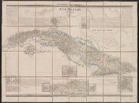
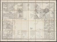
- Beinecke Rare Book and Manuscript Library > Isla de Cuba / por el Teniente Coronel Capitan de Ingenieros ; D. Francisco Coello ; Las notas estadísticas e históricas han sido escritos por D. Pascual Madoz.
- Creator:
- Smith, John L., 1846-1921
- Published / Created:
- 1897
- Call Number:
- 855 1897B
- Container / Volume:
- BRBL_00641
- Image Count:
- 1
- Resource Type:
- Maps, Atlases & Globes
- Found in:
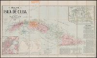
- Beinecke Rare Book and Manuscript Library > Mapa de la isla de Cuba.
- Published / Created:
- 1886
- Call Number:
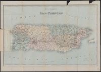
- 856 1886
- Container / Volume:
- BRBL_00643
- Image Count:
- 1
- Resource Type:
- Maps, Atlases & Globes
- Found in:
- Beinecke Rare Book and Manuscript Library > Mapa topográfico de la isla de Puerto Rico.
- Creator:
- Coello, Francisco, 1822-1898
- Published / Created:
- 1851
- Call Number:
- 855 1851
- Container / Volume:
- BRBL_00641
- Image Count:
- 1
- Resource Type:
- Maps, Atlases & Globes
- Found in:
- Beinecke Rare Book and Manuscript Library > Isla de Cuba / por el Teniente Coronel Capitan de Ingenieros ; D[on] Francisco Coello.
- Creator:
- Quijano, Fiacro
- Published / Created:
- 188-?]
- Call Number:
- 88191 G936 188x
- Container / Volume:
- BRBL_00653
- Image Count:
- 1
- Resource Type:
- Maps, Atlases & Globes
- Found in:
- Beinecke Rare Book and Manuscript Library > Plano de la triangulacion practicada entre Campo Astronómico y Cabo Haro, en el puerto de Guaymas : á fin de deducir la posicion geográfica del último punto de la del primero de los mencionados / levantado por el ingeniero F. Quijano.
- Published / Created:
- 1883
- Call Number:
- 8819 J564 1883
- Container / Volume:
- BRBL_00652
- Image Count:
- 1
- Resource Type:
- Maps, Atlases & Globes
- Found in:
- Beinecke Rare Book and Manuscript Library > Mapa del canton Jimenez, estado de Chihuahua / ... levantado en tres copias por el ingo. civil nombrado para ello, C.A.Q. Wingo.
- Creator:
- Distrito Federal (Mexico). Consejo Superior de Gobierno.
- Published / Created:
- [1906?]
- Call Number:
- 88 M57 1906
- Container / Volume:
- BRBL_00647
- Image Count:
- 1
- Resource Type:
- Maps, Atlases & Globes
- Found in:
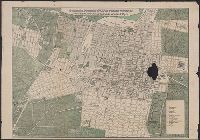
- Beinecke Rare Book and Manuscript Library > Plano oficial de la ciudad de México. : Edición especial para el Consejo Superior de Gobierno del Distrito Federal, con motivo de la reunión del X Congreso Geológico Internacional, septiembre de 1906.
- Published / Created:
- 19--?]
- Call Number:
- 88 M57 19XX
- Container / Volume:
- BRBL_00647
- Image Count:
- 1
- Resource Type:
- Maps, Atlases & Globes
- Found in:
- Beinecke Rare Book and Manuscript Library > Novisimo plano de la ciudad de México con las últimas reformas de colonias nuevas y prolongación de las calles del cinco de Mayo.
- Published / Created:
- 1887
- Call Number:
- 88gm 1887
- Container / Volume:
- BRBL_00648
- Image Count:
- 1
- Resource Type:
- Maps, Atlases & Globes
- Found in:
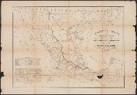
- Beinecke Rare Book and Manuscript Library > Carta telegráfica y ferrocarrilera de la República Mexicana / Secretaria de Fomento, Direccion General de Estadística.
- Published / Created:
- 1853
- Call Number:
- 88 M57 1853
- Container / Volume:
- BRBL_00647
- Image Count:
- 1
- Resource Type:
- Maps, Atlases & Globes
- Found in:
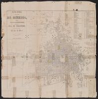
- Beinecke Rare Book and Manuscript Library > Plano general de la Ciudad de México : formado segun los datos mas recientemente adquiridos, para servir a la guia de forasteros.
- Published / Created:
- [1900]
- Call Number:
- 88 M57 1900A
- Container / Volume:
- BRBL_00647
- Image Count:
- 1
- Resource Type:
- Maps, Atlases & Globes
- Found in:
- Beinecke Rare Book and Manuscript Library > Plano general de la ciudad de México : en el que se detalla el avance de las obras del saneamiento, hasta el 31 de Diciembre de 1900.