Skip to search
Skip to main content
Skip to first result
Search
You Searched For
Date
1954 - 1955
Access
Public
Repository
Beinecke Rare Book and Manuscript Library
Resource Type
Maps, Atlases & Globes
Date Created
1954 to 1955
New Search
Search Results
Creator:
Published / Created:
[19--?]
Call Number:
796gbc 1914A
Container / Volume:
BRBL_00531
Image Count:
1
Resource Type:
Maps, Atlases & Globes
Alternative Title:
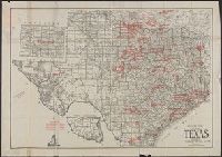
Map of Texas and Texas
Description:
Includes ill., Insets: North western portion, Texas -- Texas, southern portion., and Shows oil fields, gas fields, and pipelines.
Publisher:
F.E. Gallup Map Co.,
Subject (Geographic):
Texas--Maps
Subject (Topic):
Gas fields--Texas--Maps, Oil fields--Texas--Maps, and Pipelines--Texas--Maps
Found in:
Beinecke Rare Book and Manuscript Library > Gallup's map of Texas.
Creator:
Published / Created:
[19--?]
Call Number:
75J 1960
Container / Volume:
BRBL_00414A
Image Count:
2
Resource Type:
Maps, Atlases & Globes
Alternative Title:
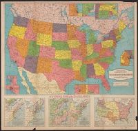
Hammond's comprehensive United States
Description:
"5365" -- lower right corner., 3 air lines distance tables, 2 population tables, and a table of historical data about the states and territories, and Includes 8 inset maps and 5 ancillary maps depicting historical information for the U.S. between 1606 and 1917.
Publisher:
C.S. Hammond & Co., Inc.,
Subject (Geographic):
United States--Maps
Found in:
Beinecke Rare Book and Manuscript Library > Hammond's Map of the United States with historical maps, historical data on states and territories, air line distances and population of cities and towns / compiled and printed expressly for Liggett's, the Rexall Drug Stores.
Creator:
Published / Created:
1954
Call Number:
739 1954
Container / Volume:
BRBL_00389
Image Count:
2
Resource Type:
Maps, Atlases & Globes
Alternative Title:
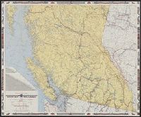
British Columbia, Canada, road map
Description:
Includes mileage chart., Relief shown by spot heights., and Text, ill., location map, and maps of "Vancouver and lower Fraser Valley" and "Northern British Columbia" on verso.
Publisher:
British Columbia Government Travel Bureau, Dept. of Trade and Industry,
Subject (Geographic):
British Columbia--Maps
Subject (Name):
British Columbia. Dept. of Lands and Forests and Geological Survey of Canada
Subject (Topic):
Roads--British Columbia--Maps
Found in:
Beinecke Rare Book and Manuscript Library > Highway and travel map of British Columbia / Basic map data by Geological Survey of Canada ; tourist information by Geographic Division, Surveys and Mapping Branch, Department of Lands and Forests.
Published / Created:
[195-?].
Call Number:
834 1881
Container / Volume:
BRBL_00587
Image Count:
2
Resource Type:
Maps, Atlases & Globes
Description:
"Our sincere thanks to ... Mr. Bruce E. Dines for the Historical Map dated 1881 which is part of 'Crofutt's guide of Colorado,' dated 1882.", Date inferred from dates cited in publication credits., Facsimile., and Includes historical photos and lists of "Area of counties," "Astronomical positions," and "Arable land."
Publisher:
W.H. Kistler Stationery Co.,
Subject (Geographic):
Colorado--Maps--Facsimiles
Subject (Name):
W.H. Kistler Stationery Co
Subject (Topic):
Maps--Facsimiles
Found in:
Beinecke Rare Book and Manuscript Library > Historical map of Colorado : compiled from U.S. Government surveys & other authentic sources, Washington, D.C. 1881.
Creator:
Published / Created:
1954
Call Number:
63 1954 Sheet 4
Container / Volume:
BRBL_00335
Image Count:
1
Resource Type:
Maps, Atlases & Globes
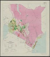
Alternative Title:
D.C.S. (Misc.) ; 203d and D.C.S. (Series) ; 203d.
Description:
"8,500/10/54 S.P.C., R.E.", "Map 3"., and "Photolithographed and printed by G.S.G.S., 1954."
Publisher:
The Directorate,
Subject (Geographic):
Kenya--Maps
Subject (Name):
Great Britain. War Office. General Staff. Geographical Section
Subject (Topic):
Land use--Kenya--Maps, Population--Kenya--Maps, Rain and rainfall--Kenya--Maps, and Tsetse-flies--Kenya--Maps
Found in:
Beinecke Rare Book and Manuscript Library > Kenya. Boundaries, land units, population, tsetse fly and rainfall [cartographic material] / drawn by Directorate of Colonial Surveys from information supplied by the Royal Commision to East Africa.
Creator:
Published / Created:
19--?]
Call Number:
71 1680A
Container / Volume:
BRBL_00360
Image Count:
1
Resource Type:
Maps, Atlases & Globes
Abstract:
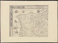
Shows Great Lakes region of North America.
Description:
"All, illustriss; et eccellentiss: S. Zaccaria Bernardi, fư dell ́Ecc. S. Francesco." and Photocopy of 17th cent. map.
Publisher:
s.n.,
Subject (Geographic):
Great Lakes Region (North America)--Maps
Subject (Name):
Bernardi, Zaccaria
Found in:
Beinecke Rare Book and Manuscript Library > La Louisiana, parte settentrionalle : scoperta sotta la protettione di Luigi XIV, Ré di Francia, etc. / descritta, e dedicata, dal P. Cosmografo Coronelli.
Published / Created:
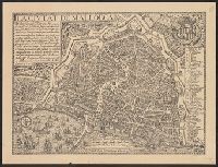
[19--?]
Call Number:
3969 P18 1644/19XX
Container / Volume:
BRBL_00194
Image Count:
1
Resource Type:
Maps, Atlases & Globes
Alternative Title:
Civtat de Mallorca
Description:
Bird's-eye view. and Positive facsimile.
Publisher:
Seix & Barral,
Subject (Geographic):
Majorca (Spain)--Maps--Early works to 1800--Facsimiles
Subject (Name):
Editorial Seix Barral
Found in:
Beinecke Rare Book and Manuscript Library > La ciutat de Mallorca / ab Antonio Garau.
Branch:v1.61.8 ,Deployed:2024-06-20T11:15:04-04:00