Search
You Searched For
Search Results
- Published / Created:
- 191-.
- Call Number:
- 11hcf 1919E-28
- Container / Volume:
- BRBL_00010ZA
- Image Count:
- 1
- Resource Type:
- Maps, Atlases & Globes
- Found in:
- Beinecke Rare Book and Manuscript Library > [Map of southern Europe and the Adriatic Sea .]
- Published / Created:
- [1700?]
- Call Number:
- 53 1700A
- Container / Volume:
- BRBL_00283
- Image Count:
- 1
- Resource Type:
- Maps, Atlases & Globes
- Found in:
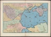
- Beinecke Rare Book and Manuscript Library > [Map of southeast Europe and the Black Sea] C. Berey Sculp.
- Published / Created:
- 1922?]
- Call Number:
- 825ad An23 1922
- Container / Volume:
- BRBL_00575
- Image Count:
- 1
- Resource Type:
- Maps, Atlases & Globes
- Found in:
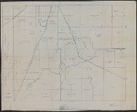
- Beinecke Rare Book and Manuscript Library > [Map of sections in townships 20 S and 21 S, and ranges 19 E and 20 E, Anderson County, Kansas] / F.S.T. 3/25/'22, Garnett, Kas.
- Published / Created:
- 1915?]
- Call Number:
- 884 1915A
- Container / Volume:
- BRBL_00654
- Image Count:
- 1
- Resource Type:
- Maps, Atlases & Globes
- Found in:
- Beinecke Rare Book and Manuscript Library > [Map of region around Tamiahua Lagoon].
- Published / Created:
- 1893?]
- Call Number:
- 88 M57 1893
- Container / Volume:
- BRBL_00647
- Image Count:
- 1
- Resource Type:
- Maps, Atlases & Globes
- Found in:
- Beinecke Rare Book and Manuscript Library > [Map of railroads in Mexico City Region].
- Published / Created:
- [1816]
- Call Number:
- 40 M59 1816
- Container / Volume:
- BRBL_00210
- Image Count:
- 1
- Resource Type:
- Maps, Atlases & Globes
- Found in:
- Beinecke Rare Book and Manuscript Library > [Map of province of Milan.]
- Published / Created:
- [18--?]
- Call Number:
- 796 1836D
- Container / Volume:
- BRBL_00716
- Image Count:
- 1
- Resource Type:
- Maps, Atlases & Globes
- Found in:
- Beinecke Rare Book and Manuscript Library > [Map of parts of Chihuahua, Coahuila and Texas, and New Mexico].
- Published / Created:
- 1945?]
- Call Number:
- 284CBF 1945
- Container / Volume:
- BRBL_00026
- Image Count:
- 1
- Resource Type:
- Maps, Atlases & Globes
- Found in:
- Beinecke Rare Book and Manuscript Library > [Map of part of Samar, Philippines, in Japanese.]
- Published / Created:
- 1884]
- Call Number:
- 32ex Ab97 1884
- Container / Volume:
- BRBL_00075
- Image Count:
- 4
- Resource Type:
- Maps, Atlases & Globes
- Found in:
- Beinecke Rare Book and Manuscript Library > [Map of one hundred square miles round Abury; showing the British and Roman Stone and Earthworks of the Downs of North Wilts; by the Rev. A.C. Smith.
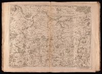
- Creator:
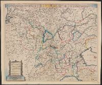
- Crépy (Firm)
Fricx, Eugène-Henri, d. 1733
Fricx, Eugène-Henri, d. 1733. Cartes des provinces des Pays Bas
- Published / Created:
- en 1744.
- Call Number:
- 1977 Folio 177
- Image Count:
- 2
- Resource Type:
- Maps, Atlases & Globes
- Found in:
- Beinecke Rare Book and Manuscript Library > [Map of northern Luxembourg and part of Luxembourg province in Belgium] / dresseíe sur les memoires de Eugene Henry Frix.
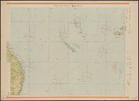
- Published / Created:
- 1945?]
- Call Number:
- 26cbf 1945D
- Container / Volume:
- BRBL_00023A
- Image Count:
- 1
- Resource Type:
- Maps, Atlases & Globes
- Found in:
- Beinecke Rare Book and Manuscript Library > [Map of northern Australia, in Japanese].
- Published / Created:
- 1945?]
- Call Number:
- 26cbf 1945A
- Container / Volume:
- BRBL_00023A
- Image Count:
- 2
- Resource Type:
- Maps, Atlases & Globes
- Found in:
- Beinecke Rare Book and Manuscript Library > [Map of northern Australia, in Japanese].
- Creator:
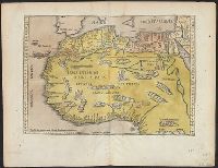
- Fries, Lorenz, ca. 1490-1531
- Published / Created:
- 1522?]
- Call Number:
- 66 1522
- Container / Volume:
- BRBL_00347
- Image Count:
- 2
- Resource Type:
- Maps, Atlases & Globes
- Found in:
- Beinecke Rare Book and Manuscript Library > [Map of northern Africa].
- Published / Created:
- 1919?]
- Call Number:
- 11hcf 1919B-18
- Container / Volume:
- BRBL_00010O
- Image Count:
- 1
- Resource Type:
- Maps, Atlases & Globes
- Found in:
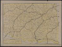
- Beinecke Rare Book and Manuscript Library > [Map of central Europe].
- Published / Created:
- 1919?]
- Call Number:
- 11hcf 1919B-18
- Container / Volume:
- BRBL_00010O
- Image Count:
- 1
- Resource Type:
- Maps, Atlases & Globes
- Found in:
- Beinecke Rare Book and Manuscript Library > [Map of central Europe].
- Published / Created:
- 1919?]
- Call Number:
- 11hcf 1919B-18
- Container / Volume:
- BRBL_00010O
- Image Count:
- 1
- Resource Type:
- Maps, Atlases & Globes
- Found in:
- Beinecke Rare Book and Manuscript Library > [Map of central Europe].
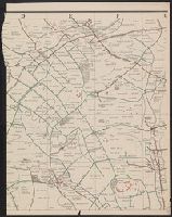
- Published / Created:
- 191-]
- Call Number:
- 11hcf 1919-2
- Container / Volume:
- BRBL_00010J
- Image Count:
- 1
- Resource Type:
- Maps, Atlases & Globes
- Found in:
- Beinecke Rare Book and Manuscript Library > [Map of area in dispute between Belgium and Germany.]
- Published / Created:
- 1918
- Call Number:
- 11hc 1918-Z3
- Container / Volume:
- BRBL_00010G
- Image Count:
- 1
- Resource Type:
- Maps, Atlases & Globes
- Found in:
- Beinecke Rare Book and Manuscript Library > [Map of area around Tartiers, France.]
- Published / Created:
- 1918
- Call Number:
- 11hc 1918-Z4
- Container / Volume:
- BRBL_00010H
- Image Count:
- 1
- Resource Type:
- Maps, Atlases & Globes
- Found in:
- Beinecke Rare Book and Manuscript Library > [Map of area around Château-Thierry, France.]
- Published / Created:
- [1890?].
- Call Number:
- 779 W27 1890
- Container / Volume:
- BRBL_00505A
- Image Count:
- 1
- Resource Type:
- Maps, Atlases & Globes
- Found in:
- Beinecke Rare Book and Manuscript Library > [Map of Washington, D.C.].
- Published / Created:
- [1872?]
- Call Number:
- BrSides Folio 2018 139
- Image Count:
- 1
- Resource Type:
- Maps, Atlases & Globes
- Found in:
- Beinecke Rare Book and Manuscript Library > [Map of Thunder Bay District, Canada, showing silver lands owned by Peter Mitchell & others, Sept. 7th, 1872].
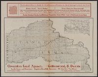
- Published / Created:
- 191-?]
- Call Number:
- 796gme 1914
- Container / Volume:
- BRBL_00531
- Image Count:
- 1
- Resource Type:
- Maps, Atlases & Globes
- Found in:
- Beinecke Rare Book and Manuscript Library > [Map of Texas showing Frisco lines and connections].
- Published / Created:
- [1910?]
- Call Number:
- 823 S25 1910
- Container / Volume:
- BRBL_00568
- Image Count:
- 1
- Resource Type:
- Maps, Atlases & Globes
- Found in:
- Beinecke Rare Book and Manuscript Library > [Map of Stanley and Lyman counties, South Dakota] / S.R. Green, Dep. State Surv., Philip, So. Dak.
- Published / Created:
- [1915?]
- Call Number:
- 771 Sa24 1915
- Image Count:
- 1
- Resource Type:
- Maps, Atlases & Globes
- Found in:
- Beinecke Rare Book and Manuscript Library > [Map of St. Lawrence County, New York].
- Published / Created:
- 1912
- Call Number:
- 734 Q31 1912
- Container / Volume:
- BRBL_00380
- Image Count:
- 1
- Resource Type:
- Maps, Atlases & Globes
- Found in:
- Beinecke Rare Book and Manuscript Library > [Map of Québec]
- Published / Created:
- 1914?]
- Call Number:
- 827gme 1914
- Container / Volume:
- BRBL_00578
- Image Count:
- 1
- Resource Type:
- Maps, Atlases & Globes
- Found in:
- Beinecke Rare Book and Manuscript Library > [Map of Oklahoma].
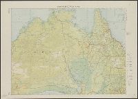
- Published / Created:
- 1945?]
- Call Number:
- 26cbf 1945C
- Container / Volume:
- BRBL_00023A
- Image Count:
- 1
- Resource Type:
- Maps, Atlases & Globes
- Found in:
- Beinecke Rare Book and Manuscript Library > [Map of New South Wales and Tasmania, in Japanese].
- Published / Created:
- 1885?]
- Call Number:
- 841 1885
- Container / Volume:
- BRBL_00596
- Image Count:
- 1
- Resource Type:
- Maps, Atlases & Globes
- Found in:
- Beinecke Rare Book and Manuscript Library > [Map of New Mexico].
- Creator:
- Wenng & Wild
Wenng, Ludwig
- Published / Created:
- [ca. 1892]
- Call Number:
- 36 M92 1890A
- Container / Volume:
- BRBL_00125
- Image Count:
- 2
- Resource Type:
- Maps, Atlases & Globes
- Found in:
- Beinecke Rare Book and Manuscript Library > [Map of Munich] / bearbeitet von Ludwig Wenng ; technisches u. kartographisches Institut.
- Published / Created:
- 19--.
- Call Number:
- 761 M79 1883
- Container / Volume:
- BRBL_00448
- Image Count:
- 1
- Resource Type:
- Maps, Atlases & Globes
- Found in:
- Beinecke Rare Book and Manuscript Library > [Map of Moosehead Lake and northern Maine, embracing the headwaters of the Penobscot, Kennebec and St. John rivers : specially adapted to the uses of sportsmen and lumbermen / compiled and published by Lucius L. Hubbard].
- Published / Created:
- [1830?]
- Call Number:
- 40 M59 1830
- Container / Volume:
- BRBL_00211
- Image Count:
- 1
- Resource Type:
- Maps, Atlases & Globes
- Found in:
- Beinecke Rare Book and Manuscript Library > [Map of Milan.]
- Published / Created:
- 1922]
- Call Number:
- 88cb 1922
- Container / Volume:
- BRBL_00648
- Image Count:
- 1
- Resource Type:
- Maps, Atlases & Globes
- Found in:
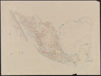
- Beinecke Rare Book and Manuscript Library > [Map of Mexico].
- Published / Created:
- 1945?]
- Call Number:
- 283CBF M339 1945A
- Container / Volume:
- BRBL_00026
- Image Count:
- 1
- Resource Type:
- Maps, Atlases & Globes
- Found in:
- Beinecke Rare Book and Manuscript Library > [Map of Marinduque, Philippines, in Japanese.]
- Creator:
- Gibson, J. (John)
- Published / Created:
- 1763]
- Call Number:
- 75 1778
- Collection Title:
- Gentleman's magazine.
- Container / Volume:
- BRBL_00689
- Image Count:
- 1
- Resource Type:
- Maps, Atlases & Globes
- Found in:
- Beinecke Rare Book and Manuscript Library > [Map of Louisiana and the western parts of Virginia and Carolina] / [cartographic material] / J. Gibson, sculp.
- Published / Created:
- [19--?]
- Call Number:
- 32 L84 1900
- Container / Volume:
- BRBL_00051
- Image Count:
- 5
- Resource Type:
- Maps, Atlases & Globes
- Found in:
- Beinecke Rare Book and Manuscript Library > [Map of London and Environs].
- Published / Created:
- [1863?]
- Call Number:
- 57 K99 1834A
- Container / Volume:
- BRBL_00303
- Image Count:
- 1
- Resource Type:
- Maps, Atlases & Globes
- Found in:
- Beinecke Rare Book and Manuscript Library > [Map of Kyoto].
- Published / Created:
- 1863
- Call Number:
- 57 K99 1834
- Container / Volume:
- BRBL_00303
- Image Count:
- 1
- Resource Type:
- Maps, Atlases & Globes
- Found in:
- Beinecke Rare Book and Manuscript Library > [Map of Kyoto].
- Published / Created:
- [1833] and 天保 4 年.
- Call Number:
- BrSides 2018 136
- Image Count:
- 1
- Resource Type:
- Maps, Atlases & Globes
- Found in:
- Beinecke Rare Book and Manuscript Library > [Map of Kyoto] [cartographic material].
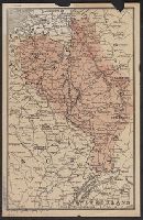
- Published / Created:
- [1917].
- Call Number:
- 11hcf 1919D-28
- Container / Volume:
- BRBL_00010X
- Image Count:
- 2
- Resource Type:
- Maps, Atlases & Globes
- Found in:
- Beinecke Rare Book and Manuscript Library > [Map of Italy and surrounding region during World War I.]
- Creator:
- Paucker, Fred
- Published / Created:
- 1957
- Call Number:
- 51 1957
- Image Count:
- 1
- Resource Type:
- Maps, Atlases & Globes
- Found in:
- Beinecke Rare Book and Manuscript Library > [Map of Israel] / Fred Paucker.
- Published / Created:
- 19--?]
- Call Number:
- 71ED 1850
- Container / Volume:
- BRBL_00371
- Image Count:
- 1
- Resource Type:
- Maps, Atlases & Globes
- Found in:
- Beinecke Rare Book and Manuscript Library > [Map of Indian tribes of North America].
- Published / Created:
- 1918.]
- Call Number:
- 11hcf 1919-44
- Container / Volume:
- BRBL_00010L
- Image Count:
- 1
- Resource Type:
- Maps, Atlases & Globes
- Found in:
- Beinecke Rare Book and Manuscript Library > [Map of Hungary showing relief ] / geographical data compiled by B. C. Wallis.
- Published / Created:
- 1918.]
- Call Number:
- 11hcf 1919-45
- Container / Volume:
- BRBL_00010L
- Image Count:
- 1
- Resource Type:
- Maps, Atlases & Globes
- Found in:
- Beinecke Rare Book and Manuscript Library > [Map of Hungary showing population density ] / geographical data compiled by B. C. Wallis.
- Published / Created:
- 1918.]
- Call Number:
- 11hcf 1919-47
- Container / Volume:
- BRBL_00010L
- Image Count:
- 1
- Resource Type:
- Maps, Atlases & Globes
- Found in:
- Beinecke Rare Book and Manuscript Library > [Map of Hungary showing nationalities] / geographical data compiled by B. C. Wallis.
- Published / Created:
- 191-.
- Call Number:
- 11hcf 1919D-50
- Image Count:
- 1
- Resource Type:
- Maps, Atlases & Globes
- Found in:
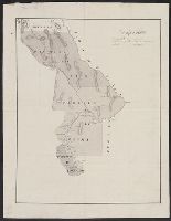
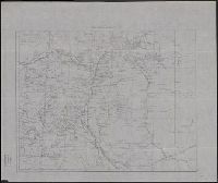
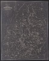
- Beinecke Rare Book and Manuscript Library > [Map of Hungary and vicinity.]
- Published / Created:
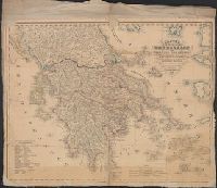
- 1842
- Call Number:
- 48 1842
- Container / Volume:
- BRBL_00264
- Image Count:
- 1
- Resource Type:
- Maps, Atlases & Globes
- Found in:
- Beinecke Rare Book and Manuscript Library > [Map of Greece].
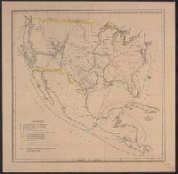
- Published / Created:
- [1849?]
- Call Number:
- 75 1849E
- Container / Volume:
- BRBL_00400
- Image Count:
- 1
- Resource Type:
- Maps, Atlases & Globes
- Found in:
- Beinecke Rare Book and Manuscript Library > [Map of Frontier Stations and lines of transportation in the U.S. and North America].
- Published / Created:
- 1900
- Call Number:
- 806 Ev17 1900
- Container / Volume:
- BRBL_00548
- Image Count:
- 1
- Resource Type:
- Maps, Atlases & Globes
- Found in:
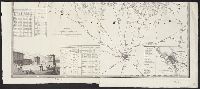
- Beinecke Rare Book and Manuscript Library > [Map of Evanston, Illinois].
- Published / Created:
- 1651
- Call Number:
- 30 1651
- Container / Volume:
- BRBL_00029
- Image Count:
- 1
- Resource Type:
- Maps, Atlases & Globes
- Found in:
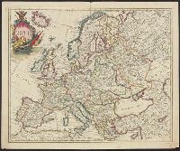
- Beinecke Rare Book and Manuscript Library > [Map of Europe] Carta Noua accurata del passagio et strada dalli Paesi Bassi per via de Allemagna per Italia et per via di paesi Sinzeri a Geneva Lione et Roma.
- Published / Created:
- [1720?]
- Call Number:
- 30 1720
- Container / Volume:
- BRBL_00029
- Image Count:
- 1
- Resource Type:
- Maps, Atlases & Globes
- Found in:
- Beinecke Rare Book and Manuscript Library > [Map of Europe, completely identical to the maps of Guillaume de L'Isle].