Search
You Searched For
Search Results
- Creator:
- United States. Army Map Service
- Published / Created:
- 1943
- Call Number:
- 533gm 1943
- Container / Volume:
- BRBL_00288
- Image Count:
- 1
- Resource Type:
- Maps, Atlases & Globes
- Found in:
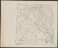
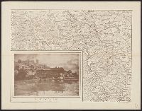
- Beinecke Rare Book and Manuscript Library > ʻIrāq [cartographic material] : special strategic map.
- Call Number:
- 783 1673D
- Container / Volume:
- BRBL_00507
- Image Count:
- 1
- Resource Type:
- Maps, Atlases & Globes
- Found in:
- Beinecke Rare Book and Manuscript Library > virginia and Maryland. As it is planted and inhabited this present year 1670. Surveyed and Exactly Drawne by ... Augustin Herrman, 1673.
- Call Number:
- 771 OS9 1836
- Container / Volume:
- BRBL_00490
- Image Count:
- 1
- Resource Type:
- Maps, Atlases & Globes
- Found in:
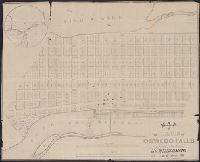
- Beinecke Rare Book and Manuscript Library > map of the Village of Oswego Falls to be Sold on hte Premises by Jas. Bleecker & Sons on the 18th October 1836.
- Published / Created:
- [1700?]
- Call Number:
- 36 R34 1700
- Container / Volume:
- BRBL_00126
- Image Count:
- 1
- Resource Type:
- Maps, Atlases & Globes
- Found in:
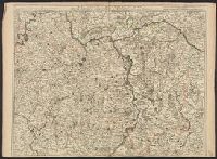
- Beinecke Rare Book and Manuscript Library > m Palatinat et Electorat du Rhin, Archevesché Electorat de Mayence ... Basse Alsace cours du Rhin ... Par Crepy.
- Published / Created:
- 1823
- Call Number:
- 89 1823
- Container / Volume:
- BRBL_00657
- Image Count:
- 1
- Resource Type:
- Maps, Atlases & Globes
- Found in:
- Beinecke Rare Book and Manuscript Library > geographisch-statistische charte von Guatemala.
- Creator:
- Mercator, Gerhard, 1512-1594
- Published / Created:
- 1595?]
- Call Number:
- 37 1595A
- Image Count:
- 2
- Resource Type:
- Maps, Atlases & Globes
- Found in:
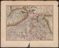
- Beinecke Rare Book and Manuscript Library > [Zurichgow et Basiliensis provincia].
- Published / Created:
- [1805?]
- Call Number:
- 3841 1805
- Container / Volume:
- BRBL_00179
- Image Count:
- 1
- Resource Type:
- Maps, Atlases & Globes
- Found in:
- Beinecke Rare Book and Manuscript Library > [Yonne, Nievre, Cote D'or] Gravé P.F. Tardieu. Ecrit par Dubuisson.
- Published / Created:
- 191-?]
- Call Number:
- 11hcf 1919D-18
- Container / Volume:
- BRBL_00010W
- Image Count:
- 2
- Resource Type:
- Maps, Atlases & Globes
- Found in:
- Beinecke Rare Book and Manuscript Library > [XII. A Népesség Hitfelekezet Szerint.]
- Creator:
- Silvani, Bernardo
- Published / Created:
- Anno Domini 1511]
- Call Number:
- 11 1511A
- Container / Volume:
- BRBL_00732
- Image Count:
- 1
- Resource Type:
- Maps, Atlases & Globes
- Found in:
- Beinecke Rare Book and Manuscript Library > [World map].
- Creator:
- Silvani, Bernardo
- Published / Created:
- 1511]
- Call Number:
- 11 1511
- Container / Volume:
- BRBL_00732
- Image Count:
- 2
- Resource Type:
- Maps, Atlases & Globes
- Found in:
- Beinecke Rare Book and Manuscript Library > [World map].
- Published / Created:
- March 1880.
- Call Number:
- 11 1584
- Container / Volume:
- BRBL_00722
- Image Count:
- 2
- Resource Type:
- Maps, Atlases & Globes
- Found in:
- Beinecke Rare Book and Manuscript Library > [World map].
- Published / Created:
- March 1880.
- Call Number:
- 11 1600
- Container / Volume:
- BRBL_00002
- Image Count:
- 1
- Resource Type:
- Maps, Atlases & Globes
- Found in:
- Beinecke Rare Book and Manuscript Library > [World map].
- Published / Created:
- March 1880.
- Call Number:
- 11 1600
- Image Count:
- 1
- Resource Type:
- Maps, Atlases & Globes
- Found in:
- Beinecke Rare Book and Manuscript Library > [World map].
- Creator:
- Ribero, Diego, d. 1533
- Published / Created:
- 1900?]
- Call Number:
- 11 1529
- Image Count:
- 2
- Resource Type:
- Maps, Atlases & Globes
- Found in:
- Beinecke Rare Book and Manuscript Library > [World map]
- Published / Created:
- 1860?]
- Call Number:
- 11 1860A
- Container / Volume:
- BRBL_00009
- Image Count:
- 1
- Resource Type:
- Maps, Atlases & Globes
- Found in:
- Beinecke Rare Book and Manuscript Library > [World map in Chinese, 1860.]
- Published / Created:
- [1853]
- Call Number:
- 11 1853
- Container / Volume:
- BRBL_00009
- Image Count:
- 1
- Resource Type:
- Maps, Atlases & Globes
- Found in:
- Beinecke Rare Book and Manuscript Library > [World Map].
- Published / Created:
- [1848]
- Call Number:
- 11 1848
- Container / Volume:
- BRBL_00009
- Image Count:
- 1
- Resource Type:
- Maps, Atlases & Globes
- Found in:
- Beinecke Rare Book and Manuscript Library > [World Map].
- Published / Created:
- [1700]
- Call Number:
- 11 1700A
- Container / Volume:
- BRBL_00004
- Image Count:
- 1
- Resource Type:
- Maps, Atlases & Globes
- Found in:
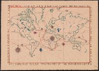
- Beinecke Rare Book and Manuscript Library > [World Map] Portugal - The Country that has contributed most to geographic knowledge of the Globe in the course of one century she discovered and explored nearly two-thirds of the inhabited Globe.
- Published / Created:
- 1845
- Call Number:
- 54635cea 1845
- Container / Volume:
- BRBL_00290
- Image Count:
- 2
- Resource Type:
- Maps, Atlases & Globes
- Found in:
- Beinecke Rare Book and Manuscript Library > [Whaling] Chart of Kamscatka, and the Sea of Ochotsk. Copied from the best Russian Authorities. ... respectfully dedicated to the Whaling Fleet of the United States.
- Published / Created:
- 1855
- Call Number:
- 811ca 1855
- Container / Volume:
- BRBL_00554
- Image Count:
- 1
- Resource Type:
- Maps, Atlases & Globes
- Found in:
- Beinecke Rare Book and Manuscript Library > [Western part of upper peninsula, Michigan].
- Published / Created:
- [1945?]
- Call Number:
- 307cbf 1945
- Container / Volume:
- BRBL_00036
- Image Count:
- 1
- Resource Type:
- Maps, Atlases & Globes
- Found in:
- Beinecke Rare Book and Manuscript Library > [Western Europe].
- Published / Created:
- [1605]
- Call Number:
- 3361 1605
- Container / Volume:
- BRBL_00088
- Image Count:
- 2
- Resource Type:
- Maps, Atlases & Globes
- Found in:
- Beinecke Rare Book and Manuscript Library > [West Flanders] Petrus Koerius coelavit.
- Published / Created:
- [1940?]
- Call Number:
- 38gmp B833 1940
- Container / Volume:
- BRBL_00171
- Image Count:
- 1
- Resource Type:
- Maps, Atlases & Globes
- Found in:
- Beinecke Rare Book and Manuscript Library > [View taken above Bruges].
- Published / Created:
- 1916?]
- Call Number:
- 38am V58 1916
- Container / Volume:
- BRBL_00168
- Image Count:
- 1
- Resource Type:
- Maps, Atlases & Globes
- Found in:
- Beinecke Rare Book and Manuscript Library > [Verdun and Environs].
- Published / Created:
- 1916?].
- Call Number:
- 38 V58 1916
- Container / Volume:
- BRBL_00166
- Image Count:
- 1
- Resource Type:
- Maps, Atlases & Globes
- Found in:
- Beinecke Rare Book and Manuscript Library > [Verdun and Environs].
- Creator:
- Bretez, Louis, d. 1738
- Published / Created:
- [1739?]
- Call Number:
- 1973 folio 44
- Collection Title:
- Plan de Paris commence l’annee 1734. Dessine et grave sous les ordres de Messire Michel Etienne
- Image Count:
- 1
- Resource Type:
- Maps, Atlases & Globes
- Found in:
- Beinecke Rare Book and Manuscript Library > [Untitled sectional plan of Paris]
- Creator:
- Bretez, Louis, d. 1738
- Published / Created:
- [1739?]
- Call Number:
- 1973 folio 44
- Collection Title:
- Plan de Paris commence l’annee 1734. Dessine et gravesous les ordres de Messire Michel Etienne
- Image Count:
- 1
- Resource Type:
- Maps, Atlases & Globes
- Found in:
- Beinecke Rare Book and Manuscript Library > [Untitled sectional plan of Paris]
- Published / Created:
- [1808]
- Call Number:
- In W890 Zz808
- Collection Title:
- The history of the rise, progress, and accomplishment of the abolition of the African slave-trade
- Image Count:
- 1
- Resource Type:
- Maps, Atlases & Globes
- Found in:
- Beinecke Rare Book and Manuscript Library > [Untitled map of abolition of the slave trade]
- Published / Created:
- c1902.
- Call Number:
- 75gme 1915
- Container / Volume:
- BRBL_00414A
- Image Count:
- 1
- Resource Type:
- Maps, Atlases & Globes
- Found in:
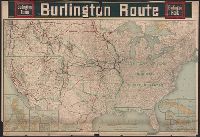
- Beinecke Rare Book and Manuscript Library > [United States] Burlington Route / Burlington R.R.
- Published / Created:
- [1920?].
- Call Number:
- 75 1920
- Container / Volume:
- BRBL_00407A
- Image Count:
- 2
- Resource Type:
- Maps, Atlases & Globes
- Found in:
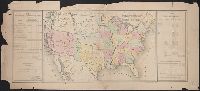
- Beinecke Rare Book and Manuscript Library > [United States] / printed by Rand McNally & Company for free distribution through the newspapers represented by Frederic J. Haskin ; photographs by Harris & Ewing.
- Published / Created:
- 1866
- Call Number:
- 75 1866H
- Container / Volume:
- BRBL_00403
- Image Count:
- 1
- Resource Type:
- Maps, Atlases & Globes
- Found in:
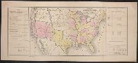
- Beinecke Rare Book and Manuscript Library > [United States] / drawn by A. Lindenkohl ; Chas. G. Krebs, Litho.
- Published / Created:
- 1848?]
- Call Number:
- 75 1848C
- Container / Volume:
- BRBL_00399
- Image Count:
- 1
- Resource Type:
- Maps, Atlases & Globes
- Found in:
- Beinecke Rare Book and Manuscript Library > [United States Treaties] E. Gilman, draftsman. P.S. Duval's Steam lith. press, Philadelphia.
- Published / Created:
- 1848?]
- Call Number:
- 75 1848B
- Container / Volume:
- BRBL_00399
- Image Count:
- 1
- Resource Type:
- Maps, Atlases & Globes
- Found in:
- Beinecke Rare Book and Manuscript Library > [United States Treaties] E. Gilman, draftsman. P.S. Duval's Steam lith. press, Philadelphia.
- Published / Created:
- 1840-1844.
- Call Number:
- 23 1844
- Container / Volume:
- BRBL_00020
- Image Count:
- 3
- Resource Type:
- Maps, Atlases & Globes
- Found in:
- Beinecke Rare Book and Manuscript Library > [U.S. Exploring Expedition Pacific Ocean] Engraved by Sherman and Smith, New York. By the U.S. Ex.Ex.
- Published / Created:
- 188-]
- Call Number:
- 754GM 1880
- Container / Volume:
- BRBL_00419
- Image Count:
- 1
- Resource Type:
- Maps, Atlases & Globes
- Found in:
- Beinecke Rare Book and Manuscript Library > [Two maps showing the southern Atlantic states to point out the transportation routes to the Seaboard Central and Seaboard Southern routes].
- Published / Created:
- 1825
- Call Number:
- 23cea 1825A
- Container / Volume:
- BRBL_00021
- Image Count:
- 2
- Resource Type:
- Maps, Atlases & Globes
- Found in:
- Beinecke Rare Book and Manuscript Library > [Two charts of the Pacific Ocean, showing the Northwestern America and Sandwich Islands and ports].
- Published / Created:
- [1940?]
- Call Number:
- 456 1940A
- Container / Volume:
- BRBL_00259
- Image Count:
- 1
- Resource Type:
- Maps, Atlases & Globes
- Found in:
- Beinecke Rare Book and Manuscript Library > [Transylvania] / Entworfen von Robert Csallner.
- Published / Created:
- [1940?]
- Call Number:
- 456 1918A
- Container / Volume:
- BRBL_00259
- Image Count:
- 1
- Resource Type:
- Maps, Atlases & Globes
- Found in:
- Beinecke Rare Book and Manuscript Library > [Transylvania] / Entworfen von Robert Csallner.
- Published / Created:
- [1940?]
- Call Number:
- 456 1918
- Container / Volume:
- BRBL_00259
- Image Count:
- 1
- Resource Type:
- Maps, Atlases & Globes
- Found in:
- Beinecke Rare Book and Manuscript Library > [Transylvania] / Entworfen von Robert Csallner.
- Published / Created:
- 1873?]
- Call Number:
- 844cbf 1873A
- Container / Volume:
- BRBL_00613
- Image Count:
- 1
- Resource Type:
- Maps, Atlases & Globes
- Found in:
- Beinecke Rare Book and Manuscript Library > [Topographical map of central California].
- Published / Created:
- [1940?-1941]
- Call Number:
- 42 1940
- Container / Volume:
- BRBL_00244
- Image Count:
- 13
- Resource Type:
- Maps, Atlases & Globes
- Found in:
- Beinecke Rare Book and Manuscript Library > [Topographical map of Austria. 1: 25,000].
- Published / Created:
- 1863
- Call Number:
- 783 Or1 1863
- Container / Volume:
- BRBL_00510
- Image Count:
- 1
- Resource Type:
- Maps, Atlases & Globes
- Found in:
- Beinecke Rare Book and Manuscript Library > [Topographic military map of region around Orange Courthouse, south to Mechanicsburg, east to Robertson's tavern, north to Madison C.H. and west to Burtonsville] / Office of Surveys and Maps for the Army of the Potomac.
- Published / Created:
- [1779]
- Call Number:
- 787hca Sa91 1779P
- Container / Volume:
- BRBL_00730
- Image Count:
- 1
- Resource Type:
- Maps, Atlases & Globes
- Found in:
- Beinecke Rare Book and Manuscript Library > [The siege of Savannah, 1779].
- Published / Created:
- [19--]
- Call Number:
- 11 1482
- Image Count:
- 1
- Resource Type:
- Maps, Atlases & Globes
- Found in:
- Beinecke Rare Book and Manuscript Library > [The World according to Pomponius Mela. Venice, 1482].
- Published / Created:
- 1918.]
- Call Number:
- 11hc 1917L
- Container / Volume:
- BRBL_00010D
- Image Count:
- 1
- Resource Type:
- Maps, Atlases & Globes
- Found in:
- Beinecke Rare Book and Manuscript Library > [The Western front Situation Map.]
- Published / Created:
- 1916
- Call Number:
- 11hc 1916
- Container / Volume:
- BRBL_00010C
- Image Count:
- 1
- Resource Type:
- Maps, Atlases & Globes
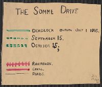
- Found in:
- Beinecke Rare Book and Manuscript Library > [The Somme Drive.]
- Creator:
- Des Barres, Joseph F. W. (Joseph Frederick Wallet), 1722-1824
- Published / Created:
- 1775?-1781?]
- Call Number:
- 1983 Folio 25
- Image Count:
- 3
- Resource Type:
- Maps, Atlases & Globes
- Found in:
- Beinecke Rare Book and Manuscript Library > [The Atlantic Neptune : published for the use of the Royal Navy Great Britain / by Joseph F.W. Des Barres, esq.].
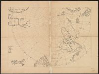
- Published / Created:
- [1650?]
- Call Number:
- 18 1650
- Container / Volume:
- BRBL_00012
- Image Count:
- 1
- Resource Type:
- Maps, Atlases & Globes
- Found in:
- Beinecke Rare Book and Manuscript Library > [The Arctic Regions].
- Published / Created:
- [187-?]
- Call Number:
- 582 B22 187X
- Container / Volume:
- BRBL_00707
- Image Count:
- 1
- Resource Type:
- Maps, Atlases & Globes
- Found in:
- Beinecke Rare Book and Manuscript Library > [Thailand, from Bangkok west to Phet Buri].
- Creator:
- Coronelli, Vincenzo, 1650-1718
- Call Number:
- Lanman 11 1693
- Image Count:
- 1
- Resource Type:
- Maps, Atlases & Globes
- Found in:
- Beinecke Rare Book and Manuscript Library > [Terrestrial and celestial globe gore maps] / aut. il. P. Coronelli ad uso dell' Academia Cosmografica degli Argonauti.