Skip to search
Skip to main content
Skip to first result
Search
You Searched For
Date
1954 - 1955
Repository
Beinecke Rare Book and Manuscript Library
Resource Type
Maps, Atlases & Globes
Date Created
1954 to 1955
New Search
Search Results
Creator:
Published / Created:
[19--?]
Call Number:
57AM K99 1920
Container / Volume:
BRBL_00305
Image Count:
2
Resource Type:
Maps, Atlases & Globes
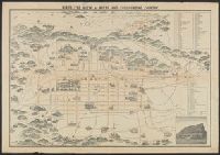
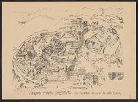
Description:
Bird's eye view., In Japanese and English., Includes a view of a temple, index and legend., Lithograph., and Oriented with north to the left.
Publisher:
K. Kawakami,
Subject (Geographic):
Kyoto (Japan)--Maps
Found in:
Beinecke Rare Book and Manuscript Library > Bird's eye view of Kioto and surrounding country / Y. Shimidzu.
Creator:
Published / Created:
19--?]
Call Number:
11hcf 1919D-8
Container / Volume:
BRBL_00010Y
Image Count:
1
Resource Type:
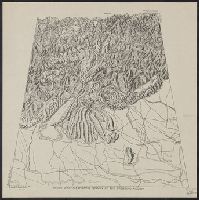
Maps, Atlases & Globes
Description:
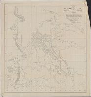
Copy, at reduced scale, of diagram issued by the American Geographical Society. and Railroads are shown.
Subject (Geographic):
Trentino-Alto Adige (Italy)--Block diagrams
Found in:
Beinecke Rare Book and Manuscript Library > Block diagram showing terrain of the Trentino region [cartographic material].
Creator:
Published / Created:
19--?]
Call Number:
11hcf 1919E-26
Container / Volume:
BRBL_00010ZA
Image Count:
1
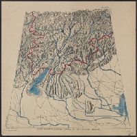
Resource Type:
Maps, Atlases & Globes
Description:
Copy, at reduced scale, of diagram issued by the American Geographical Society. and Railroads are shown.
Subject (Geographic):
Trentino-Alto Adige (Italy)--Block diagrams
Found in:
Beinecke Rare Book and Manuscript Library > Block diagram showing terrain of the Trentino region [cartographic material].
Published / Created:
19--?]
Call Number:
4035CBD 1900
Container / Volume:
BRBL_00234
Image Count:
1
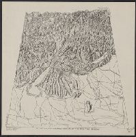
Resource Type:
Maps, Atlases & Globes
Description:
Copy, at reduced scale, of diagram issued by the American Geographical Society. and Railroads are shown.
Subject (Geographic):
Trentino-Alto Adige (Italy)--Block diagrams
Subject (Name):
American Geographical Society of New York
Found in:
Beinecke Rare Book and Manuscript Library > Block diagram showing terrain of the Trentino region [cartographic material].
Creator:
Published / Created:
19--]
Call Number:
59 B639 1932
Container / Volume:
BRBL_00318
Image Count:
5
Resource Type:
Maps, Atlases & Globes
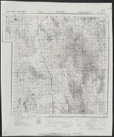
Description:
"Heliozincographed at the Survey of India Offices, Calcutta." in lower right margins., "Surveyed 1924-25" in upper left margins., Includes index to sheets, index to districts., and No. 47 A/15 and A/11. Bombay Suburban & Thāna Districts [Sheet 1] -- No. 47 E/3.
Publisher:
s.n.,
Subject (Geographic):
Bombay (India)--Maps
Subject (Name):
Gunter, C.P
Found in:
Beinecke Rare Book and Manuscript Library > Bombay / published under the direction of Lieutenant Colonel C.P. Gunter, O.B.E., R.E., Officiating Surveyor General of India, 1926.
Published / Created:
19--?].
Call Number:
38 C118 1960
Container / Volume:
BRBL_00156
Image Count:
1
Resource Type:
Maps, Atlases & Globes
Publisher:
s.n.,
Subject (Geographic):
Cagnes-sur-Mer (France)--Maps
Found in:
Beinecke Rare Book and Manuscript Library > Cagnes Fortin Médiéval : Plan promenade / édité par les Amis du Vieux Cagnes.
Creator:
Published / Created:
[1954?]
Call Number:
844gmb 1954
Container / Volume:
BRBL_00616
Image Count:
2
Resource Type:
Maps, Atlases & Globes
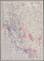
Alternative Title:
Texaco touring map of California, Nevada. and Texaco touring map of Washington, Oregon.
Description:
"3-4400-27.", "3-4432-29.", "Copyright by Rand McNally & Company.", Date based on gasoline tax table dated Jan. 1954., Includes indexes., Panel title., Relief shown pictorially and by spot heights., and Texaco touring map of Washington, Oregon -- Texaco touring map of California, Nevada.
Publisher:
Rand McNally,
Subject (Geographic):
Pacific States--Road maps
Subject (Name):
Texas Company
Found in:
Beinecke Rare Book and Manuscript Library > California-Nevada with Oregon-Washington.
Creator:
Published / Created:
19--?]
Call Number:
71 1683
Container / Volume:
BRBL_00360
Image Count:
1
Resource Type:
Maps, Atlases & Globes
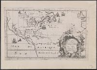
Description:
Photocopy of map from Hennepin's Description de la Louisiane. Paris, 1683. and Relief shown pictorially.
Publisher:
s.n.,
Subject (Geographic):
North America--Maps
Subject (Name):
Guérard, Nicholas and Hennepin, Louis, 17th cent. Description de la Louisiane, nouvellement decouverte au sud' oüest de la Nouvelle France, par ordre du roy
Found in:
Beinecke Rare Book and Manuscript Library > Carte de la Nouvelle France : et de la Louisiane nouvellement decouverte dediee au roy l'an 1683 / par le Reverend Pere Louis Hennepin, missionaire recollect et notaire apostoliquen ; N.Guerard ... et fecit.
Creator:
Published / Created:
19--?]
Call Number:
73 1814
Container / Volume:
BRBL_00374
Image Count:
1
Resource Type:
Maps, Atlases & Globes
Description:
"This map made for the North West Company in 1813 and 1814 ....", Covers British Columbia, portions of Alberta, and U.S. Pacific Northwest., Includes text., Relief shown by hachures., and Reprint of 1814[?] map.
Publisher:
s.n.,
Subject (Geographic):
Canada, Western--Maps and Northwest, Pacific--Maps
Subject (Name):
Canada. Office of the Surveyor General
Found in:
Beinecke Rare Book and Manuscript Library > Copy of a portion of map of the North-West territory of the Province of Canada : from actual survey during the years 1798 to 1812 / by David Thompson.
Published / Created:
1954
Call Number:
36f 1953
Container / Volume:
BRBL_00128
Image Count:
3
Resource Type:
Maps, Atlases & Globes
Alternative Title:
Der Volksaufstand vom 17. Juni 1953 in der Sowjetischen Besatzungzone und in Ostberlin
Publisher:
Bundesministerium für Gesamtdeutsche Fragen,
Subject (Geographic):
Germany (East)--History--Maps
Found in:
Beinecke Rare Book and Manuscript Library > Der Volksaufstand vom 17. Juni 1953.
Branch:v1.61.6 ,Deployed:2024-06-12T09:55:36-04:00