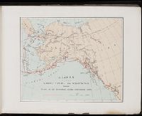
A souvenir of the Harriman Alaska Expedition : May-August, 1899 [graphic]
Image Count:
1
Resource Type:
Maps, Atlases & Globes
Abstract:
Edward Henry Harriman organized and funded a scientific expedition up the Alaska coast that included George Bird Grinnell, Grove Karl Gilbert, John Muir, Frederick Dellenbaugh, C. Hart Merriam, and other scientists, artists and writers, as well as his own
Subject (Geographic):
Alaska--Description and travel
Subject (Name):
Harriman Alaska Expedition (1899)--Pictorial works
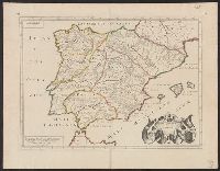
"Dedié au Roy par son très humble, très obeissant, très fidele suget et serviteur. Hubert Iaillot, géographe de Sa Majeste.", Appears in Jaillot's Atlas françois., Boundaries hand colored., Includes eight bar scales., Relief shown pictorially., and Sheet mea
Subject (Geographic):
North America--Maps--Early works to 1800
Subject (Name):
Albany Institute Stamp, Cordier, Louis, -1711, engraver, and Jaillot, Alexis Hubert, 1632?-1712. Atlas françois
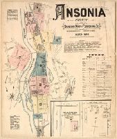
Sanborn fire insurance maps are a rich source of historic data on the urban built environment of North America during the 19th and early 20th centuries. The atlases were created for the purpose of underwriting fire insurance policies, which depended upon accurate and frequently-updated information about construction materials, municipal and transportation infrastructure, industrial and commercial landuse and more. The Yale University Library Map Department scanned its holdings of Sanborn fire insurance maps (consisting primarily of Connecticut towns) in order to make the maps more accessible.
Alternative Title:
March, 1884, Ansonia, Conn.
Description:
Contains information on population, water facilities, and fire department., Includes index of streets and specials., Partial cadastral map., and SMLMAPL 766 An81 1884: Imperfect: title sheet (sheet 1) wanting. Sheets disbound. "Triplicate" stamp on all sheets.
Subject (Geographic):
Ansonia (Conn.)--Maps
Subject (Topic):
Fire risk assessment--Connecticut--Ansonia--Maps and Real property--Connecticut--Ansonia--Maps
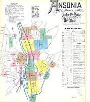
Sanborn fire insurance maps are a rich source of historic data on the urban built environment of North America during the 19th and early 20th centuries. The atlases were created for the purpose of underwriting fire insurance policies, which depended upon accurate and frequently-updated information about construction materials, municipal and transportation infrastructure, industrial and commercial landuse and more. The Yale University Library Map Department scanned its holdings of Sanborn fire insurance maps (consisting primarily of Connecticut towns) in order to make the maps more accessible.
Alternative Title:
Ansonia, Connecticut and Dec. 1890, Ansonia, Conn.
Description:
"13 sheets (4176).", Contains information on population, water facilities, and fire department., Includes index of streets and specials., Partial cadastral map., and SMLMAPL 766 An81 1890: Sheets disbound. "Triplicate" stamp on all sheets. Library of Congress copyright stamp on title sheet.
Subject (Geographic):
Ansonia (Conn.)--Maps
Subject (Name):
Library of Congress Stamp
Subject (Topic):
Fire risk assessment--Connecticut--Ansonia--Maps and Real property--Connecticut--Ansonia--Maps
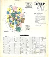
Sanborn fire insurance maps are a rich source of historic data on the urban built environment of North America during the 19th and early 20th centuries. The atlases were created for the purpose of underwriting fire insurance policies, which depended upon accurate and frequently-updated information about construction materials, municipal and transportation infrastructure, industrial and commercial landuse and more. The Yale University Library Map Department scanned its holdings of Sanborn fire insurance maps (consisting primarily of Connecticut towns) in order to make the maps more accessible.
Alternative Title:
Ansonia, Connecticut and Mar. 1924, Ansonia, Conn.
Description:
"39 sheets (1516).", Contains information on population, prevailing winds, water facilities, and fire department., Includes index of streets and specials., Partial cadastral map., and SMLMAPL 766 An81 1924: Sheets disbound.
Subject (Geographic):
Ansonia (Conn.)--Maps
Subject (Topic):
Fire risk assessment--Connecticut--Ansonia--Maps and Real property--Connecticut--Ansonia--Maps
"Cum priuilegio Regio.", Bar scale given in "scala milliarum.", Hand colored borders., Ms. no. on recto and verso: 155. Stamp on vers, and Relief shown pictorially.