Skip to search
Skip to main content
Skip to first result
Search
You Searched For
Repository
Beinecke Rare Book and Manuscript Library
Subject (Topic)
Railroads--Kansas--Maps
Subject (Geographic)
Kansas--Maps
New Search
Search Results
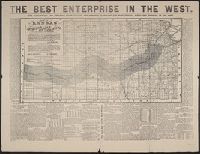
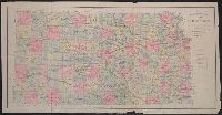
Published / Created:
1873?]
Call Number:
825gme 1873
Container / Volume:
BRBL_00576
Image Count:
2
Resource Type:
Maps, Atlases & Globes
Alternative Title:
Atchison, Topeka and Santa-Fe Railroad and connections., Best enterprise in the West., and Map of Kansas.
Description:
Date inferred from references to 1873 in text., In top margin: The best enterprise in the West., Includes text., and Relief shown by hachures.
Publisher:
s.n.,
Subject (Geographic):
Kansas--Maps
Subject (Name):
Atchison, Topeka, and Santa Fe Railroad Company, Atchison, Topeka, and Santa Fe Railroad Company--Maps, Bogart & Stillman, Fisk & Russell, and Poor, C
Subject (Topic):
Railroad land grants--Kansas--Maps, Railroads--Kansas--Maps, and Railroads--West (U.S.)--Maps
Found in:
Beinecke Rare Book and Manuscript Library > Atchison, Topeka & Santa-Fe Railroad and connections : with 3,000,000 acres land for sale on eleven years credit & seven percent interest / Fisk & Russell, N.Y. Map of Kansas / Atchison, Topeka & Santa-Fe Railroad ; Bogart & Stillman, engravers, Cin. O.
Creator:
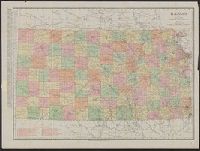
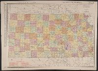
Published / Created:
1911
Call Number:
825 1911
Container / Volume:
BRBL_00573
Image Count:
1
Resource Type:
Maps, Atlases & Globes
Alternative Title:
Rand-McNally indexed pocket map and shippers' guide of Kansas
Description:
"Showing all railroads, cities, towns, villages, postoffices, lakes, rivers, etc."--Cover of text., Indexed., Library's copy missing text., Relief shown by hachures., and Shows railroads, military reservations, postal and express services.
Publisher:
The Company,
Subject (Geographic):
Kansas--Maps
Subject (Topic):
Railroads--Kansas--Maps
Found in:
Beinecke Rare Book and Manuscript Library > Kansas / Rand-McNally & Co.
Creator:
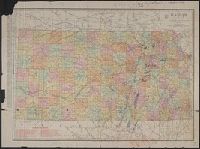
Published / Created:
1911
Call Number:
825gbc 1911
Container / Volume:
BRBL_00576
Image Count:
2
Resource Type:
Maps, Atlases & Globes
Description:
Below scale: Rand McNally & Co.'s new business atlas map of Kansas. Copyright 1911 ... Copyright 1903 ...., Imperfect. Chipped with some loss of text: Ms. annotations to indicate oil fields and drilling., Indexed on verso., Indexed., Relief shown by hachures., and Shows counties and railroads.
Publisher:
The Company,
Subject (Geographic):
Kansas--Maps
Subject (Topic):
Railroads--Kansas--Maps
Found in:
Beinecke Rare Book and Manuscript Library > Kansas / Rand-McNally & Co.
Published / Created:
c1888.
Call Number:
825gme 1888
Container / Volume:
BRBL_00576
Image Count:
1
Resource Type:
Maps, Atlases & Globes
Publisher:
Rand, McNally and Co.,
Subject (Geographic):
Kansas--Maps
Subject (Name):
Kansas. Board of Railroad Commissioners and Rand McNally and Company
Subject (Topic):
Railroads--Kansas--Maps
Found in:
Beinecke Rare Book and Manuscript Library > Map of Kansas / issued by the State Board of Railroad Commissioners.
Creator:
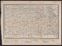
Published / Created:
[between 1877 and 1883?]
Call Number:
825fac 1883
Container / Volume:
BRBL_00575
Image Count:
1
Resource Type:
Maps, Atlases & Globes
Alternative Title:
Topographical map of Kansas from the official atlas of Kansas
Description:
Relief shown by shading., Shows railroads, townships, military and Indian reservations, and land district boundaries., and Without cover.
Subject (Geographic):
Kansas--Maps
Subject (Topic):
Railroads--Kansas--Maps
Found in:
Beinecke Rare Book and Manuscript Library > Official topographical map of Kansas / compiled from government surveys, official records, and personal investigations.
Creator:
Published / Created:
1914
Call Number:
825gbc 1914
Container / Volume:
BRBL_00576
Image Count:
2
Resource Type:
Maps, Atlases & Globes
Alternative Title:
New commercial atlas map of Kansas and Rand, McNally & Co.'s new business atlas map of Kansas.
Description:
"260" and "261.", Also shows railroads., In lower right corner: Rand, McNally & Co.'s new business atlas map of Kansas. Copyright 1903 by Rand McNally & Co., In top margin: Commercial atlas of America, Kansas., Inde, Indexed on verso., and Relief shown by hachures.
Publisher:
Rand McNally,
Subject (Geographic):
Kansas--Maps
Subject (Name):
Rand McNally and Company. Commercial atlas of America
Subject (Topic):
Railroads--Kansas--Maps
Found in:
Beinecke Rare Book and Manuscript Library > The Rand-McNally new commercial atlas map of Kansas.
Creator:
Published / Created:
[1914?]
Call Number:
825gbc 1914A
Container / Volume:
BRBL_00576
Image Count:
2
Resource Type:
Maps, Atlases & Globes
Alternative Title:
New commercial atlas map of Kansas
Description:
Also shows railroads., Date inferred from estimated 1914 population on verso., In lower right: 217A., Indexed on verso., Indexed., and Relief shown by hachures.
Publisher:
Rand McNally,
Subject (Geographic):
Kansas--Maps
Subject (Topic):
Railroads--Kansas--Maps
Found in:
Beinecke Rare Book and Manuscript Library > The Rand-McNally new commercial atlas map of Kansas.
Branch:v1.61.6 ,Deployed:2024-06-12T09:55:19-04:00