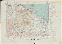
Great Britain. Army. Royal Engineers. Field Survey Coy., 512th
Published / Created:
1942
Call Number:
685 G11 1943
Container / Volume:
BRBL_00351
Image Count:
1
Resource Type:
Maps, Atlases & Globes
Alternative Title:
1:500,000 French North Africa ; Sheet N.I. 32 - S.E. GABES, 1:500,000 French North Africa ; Sheet N.I. 32 - S.E. GABES., and Sheet 1
Description:
"Copied from a French map dated 1935, with revision to communications from Intelligence reports of 1941. Photolithographed by War Office, 1942.", "Not to be published" printed along header., "Reproduced by 512 Fd. Survey Coy., R.E., Jan., 1943"., and Includes gl
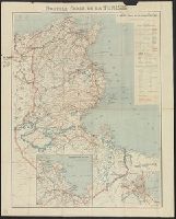
Great Britain. War Office. General Staff. Geographical Section
Published / Created:
1943
Call Number:
685gm 1943
Container / Volume:
BRBL_00351
Image Count:
2
Resource Type:
Maps, Atlases & Globes
Alternative Title:
Geographical Section, General Staff ; no. 4408 and GSGS (Series) ; 4408.
Description:
"Copied from an Italian map date 1940, compiled by Sezione topografica del fronti Tunisini.", "Published by War Office, 1943.", Insets: Ghardimaou.--Nefza.--Souk-el-Arbd.--Souk, and Twelve classes of roads and tracks, and three gauges of railroads are indicated.
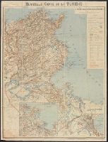
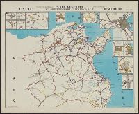
Germany. Heer. Abteilung für Kriegskarten- und Vermessungswesen
Published / Created:
1943
Call Number:
685 1943B
Container / Volume:
BRBL_00351
Image Count:
2
Resource Type:
Maps, Atlases & Globes
Alternative Title:
Fumm Tatawin and Tunesien-Algerien
Description:
Based on: Carte d'Algérie et de Tunisie 1:200,000 / Service géologique de l'Armée., Includes indexes to adjoining sheets and administrative boundary diagrams., Military grid., and Relief shown by form lines, shading, hachures, and spot heights. Depths shown b