Skip to search
Skip to main content
Skip to first result
Search
You Searched For
Date
1877 - 1877
Repository
Beinecke Rare Book and Manuscript Library
Date Created
1877
Subject (Geographic)
Turkey--Maps
New Search
Search Results
Creator:
Published / Created:
[1877]
Call Number:
492 1877
Container / Volume:
BRBL_00270
Image Count:
1
Resource Type:
Maps, Atlases & Globes
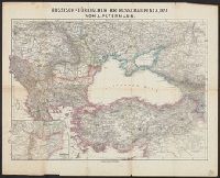
Description:
Insets: Der Bosporus -- Strasse der Dardanellen. and Relief shown by hachures. Depths shown by soundings on some insets.
Publisher:
C. Flemming,
Subject (Geographic):
Bulgaria--Maps, Caucasus, South--Maps, Turkey--Maps, and Ukraine--Maps
Subject (Name):
Carl Flemming (Firm)
Subject (Topic):
Black Sea Region--Maps
Found in:
Beinecke Rare Book and Manuscript Library > Das schwarze Meer, nebst Kriegsschauplatz in der eüropäisch. u. asiatisch. Türkei / von F. Handtke.
Creator:
Published / Created:
[1877]
Call Number:
492 1854
Container / Volume:
BRBL_00270
Image Count:
1
Resource Type:
Maps, Atlases & Globes
Description:
Insets: Umgebung von Warna -- Balkanpässe -- Umgebung von Schumla -- Umgebung von Silistria -- Umgebung von Rustschuck -- Köstendshe -- Der Bosporus -- Strasse der Dardanellen -- Häfen von Ssewastopol. and Relief shown by hachures. Depths shown by sounding
Publisher:
C. Flemming,
Subject (Geographic):
Bulgaria--Maps, Caucasus, South--Maps, Turkey--Maps, and Ukraine--Maps
Subject (Name):
Carl Flemming (Firm)
Subject (Topic):
Black Sea Region--Maps
Found in:
Beinecke Rare Book and Manuscript Library > Das schwarze Meer, nebst Kriegsschauplatz in der eüropäisch. u. asiatisch. Türkei [cartographic material] / von F. Handtke.
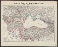
Creator:
Published / Created:
1877
Call Number:
53 1877
Container / Volume:
BRBL_00285
Image Count:
1
Resource Type:
Maps, Atlases & Globes
Description:
Relief shown by hachures and spot heights.
Publisher:
Perthes,
Subject (Geographic):
Turkey--Maps
Found in:
Beinecke Rare Book and Manuscript Library > Russisch-türkischer Kriegsschauplatz, 1877 / von A. Petermann.
Creator:
Published / Created:
1877
Call Number:
53 1877A
Container / Volume:
BRBL_00285
Image Count:
2
Resource Type:
Maps, Atlases & Globes
Alternative Title:
Map of Turkey and parts adjacent
Description:
"June 1877.", Includes location map and glossary., Inset map covering southern Europe and northern Africa., and Relief shown by hachures.
Publisher:
Office of the Chief of Engineers,
Subject (Geographic):
Balkan Peninsula--Maps and Turkey--Maps
Subject (Name):
Callahan, Denis and Humphreys, A. A. (Andrew Atkinson), 1810-1883
Found in:
Beinecke Rare Book and Manuscript Library > Seat of war in the east, map of Turkey and parts adjacent / compiled and published by authority of the Hon. the Sec. of War in the Office of the Chief of Engineers under the direction of A.A. Humphreys ; compiled and drawn by Denis Callahan.
Branch:v1.64.0 ,Deployed:2024-09-11T10:25:25-04:00