United States. Office of Strategic Services. Research and Analysis Branch
Published / Created:
1945.
Call Number:
36eb 1945B
Image Count:
1
Description:
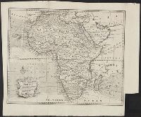
"No. 6381-R & A, OSS, 28 April 1945.", Inset: [Düsseldorf-Münster area]., and "Population data compiled in the Department of State, Division of Geography and Cartography."
Coordinates based on index map ([1] leaf of plates). and On each map: Published according to Act of Parliament by J. Rennell ... [date]; "W. Harrison, sc."
Publisher:
James Rennell
Subject (Geographic):
Bengal (India), Bihar and Orissa (India), India, Bengal., and Bihar and Orissa.
Relief shown pictorially., "Vol. I page 717.", Appears in J. Harris' Navigantium atque itinerantium bibliotheca. 1774-1748., and Prime meridian: London.
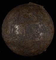
BEIN Globe 45: From the library of Stephen F. Gates. Accompanied by display plate., Terrestrial pocket globe showing the tracks of Anson's voyage, 1740-1744. Australia is drawn according to the Dutch discoveries and named New Holland., and Wooden spherical case in two parts covered with black sharkskin and lined with celestial maps of the northern and southern sky.
Publisher:
N. Hill?
Subject (Name):
Anson, George Anson, Baron, 1697-1762 and Anson, George Anson, Baron, 1697-1762.
Scale 1:633,600; miles, 10 to 1 in; metres, 1609.4 to 1 mile., Relief shown by hachures., and "Entered according to act of Congress in the year 1866 ... "
Freducci, Conte di Ottomano, active 1497-1539, cartographer
Published / Created:
[1536?]
Call Number:
Covers 49 +1536
Image Count:
6
Resource Type:
cartographic image
Description:
Title devised by cataloger., Pen-and-ink in black, red, blue, green, and gold., Four charts, each measuring 33 x 43 cm, mounted on composite boards and edged with vellum, bound in boards covered by blue cloth with label pasted on front cover (No. [1906/242 in manuscript])., and Inscription on third chart (Mediterranean region from the Strait of Gibraltar to the coast of Greece), "Yhs ma [ver]go Conte freducci de ancona la facta nela[n]no MCCCCCXXXVJ."
Publisher:
Conte di Ottomano Freducci
Subject (Geographic):
Mediterranean Region, North Atlantic Ocean, and Baltic Sea
BEIN 1973 Folio 10: Combined sheets measure 61.0 x 96.8 cm. Bookplate of José M. Rodriguez. No. 15 of 63 maps bound together., BEIN 1977 Folio 191: Imperfect: slight tears, repaired with paper on verso, with no loss of text. Combined sheets measure 63.4 x 91.3 cm. No. 33 of 52 maps bound together., Relief shown pictorially., Includes 33 coats of arms., Bar scales given in "mille pas geometriques, ou milles d'Italie," "lieues communes de France," "lieues d'une heure de Chemin," "lieues communes d'Allemagne," and "lieues communes de Suisse.", and From Alexis Hubert Jaillot's Atlas nouveau, 1692.
Cercle de Franconie, ou sont les Evechés de Wurtzburg, de Bamberg, et d'Aichstet, les Estats du grand Maistre des Chevaliers Teutons, les Marquisats de Cullembach, et d'Ohnspach, les Comtés d'Henneberg, d'Holach, de Reineck, de Wertheim, d'Erpach, de Schwartzenberg, et de Castel, les Baronies de Limpurg, et de Sensheim, et les villes imperiales de Nurenberg, de Rotenburg, de Schweinfurt, Windsheim, et de Weissenburg
Description:
BEIN 1973 Folio 10: Sheet measures 61.3 x 96.6 cm. Bookplate of José M. Rodriguez. No. 30 of 63 maps bound together., Relief shown pictorially., Ferro meridian., Bar scales in Italian miles, common leagues of Germany, great leagues of Germany, common leagues of France, great leagues of France, and leagues of one hours traveling., and Appeared in Jaillot's Atlas françois; cf. Pastoureau, M. Les atlas français, Jaillot II A, 81.
Relief shown pictorially., North oriented down., Bar scale given in unidenified units., Coordinates not present on map and are approximated., Includes index of colleges, buildings, and streets., and Insets: view of Oxforde and a map of Oxfordshire with bar scale in miles.