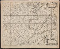
BEIN 21 1670B: Manuscript number on verso: 174. Watermark., Depths shown by isolines and soundings., Coordinates not present on map and are approximated., and From Blaeu's De groote Zee-spiegel (Amsterdam, 1655).
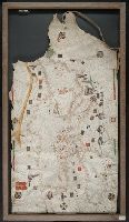
BEIN Art Storage 49cea 1425: Imperfect: lower left corner and bottom edge torn, with some loss of map; slight holes throughout. With leather thone tie on left edge., Portolan chart with seaport names given for all coastlines., Title devised by cataloger., Pen-and-ink in black, red, blue and green., Constantinople shown still in Christian possession; Thrace in possession of the Turks., Contains two compass roses., and Decoration: city views with banners.
BEIN 2014 +260: Imperfect: title page slightly mutilated, and repaired, with no loss of text. Unidentified stamp on title page. Printed label pasted at foot of title page: Musaei, Joannis Baptistae Visi Mantuani. Some manuscript annotations in text. Bookplate: From the collection of Laura K. and Valerian Lada-Mocarski. Bookseller's label: C.E. Rappaport ... Roma., In Latin., Imprint from colophon., Signatures: a-s⁶ t⁴ u⁶., Title vignette (printer's device); numerous large and small historiated woodcut initials., Illustrated with 8 woodcuts attributed to Jost Amman; 3 woodcut maps, including the originally published map of Russia from Finland to the Caspian, a pictorial version of the same area, and a plan of the walled citadel of Moscow; and a genealogical tree, compiled by Herberstein, and dated 1553, showing descendants of the royal houses of Spain and Austria., and Includes index.
Peutinger table and Tabvla itineraria ex illvstri Pevtingerorvm Bibliotheca
Description:
BEIN 2016 +333: Imperfect: title panel mutilated, with some loss of text. Sheets joined together to form a roll; backed in linen., Relief shown pictorially., "MD" in publication date in apostrophic forms., Appears in Ortelius' Theatri Orbis Terrarum Parergon. Antwerp, 1624., and "Peutinger Table: Road map of Western Roman Empire about 250 A.D. bought by Conrad Peutinger and published in Venice by Aldus in 1591 (2 sections only), in Antwerp 1598 (12 sections) ... The only record of Roman map making that has survived to the present day."--Tooley's Dictionary of Mapmakers. New York, 1979.
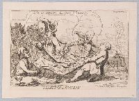
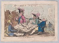
"Four monarchs divide between them a map of the territories of the Dutch Republic, all saying, "Let us support the poor Dutch!" In the background (left) the 'Stadt House' falls in ruins, and on a small rock in the sea inscribed 'Texel' a fat Dutchman in back view, looking out to sea, says, "Now, I am an Absolute Monarch"; the words ascend in the smoke of his pipe. He holds a sword and is surrounded by cackling geese. All four sovereigns hold the map, and all shed tears: George III (right) tugs at it with both hands, tearing off a piece inscribed 'Good Hope', 'Java', 'Saba', 'Eustatia', 'Curac', 'Bonaire' (?), 'Coruba', 'St Martins', 'Surinam'. Frederick William of Prussia (left), seated on the ground, wearing a fool's cap decorated with the skull and cross-bones of the Death's Head Hussars, uses a dagger to cut off a piece containing 'Friesland', 'Groningen', 'Overyisel', and 'Ceylon'. The Emperor Joseph, standing opposite Frederick William, slices the map with a large sword, securing 'Utrecht', 'Zalper' (?), 'Holland', 'Molucca Islands'. Between Joseph and George III Louis XVI, dressed as a French fop, uses a pair of shears to cut off 'Guelderland', 'Zeeland', 'Rotterda[m]', and 'Hague'."--British Museum online catalogue
Description:
Title etched below image, Printmaker from British Museum catalogue., Series title etched in upper right corner of plate. For another print in the series, see No. 7214 in the Catalogue of prints and drawings in the British Museum. Division I, political and personal satires, v. 6., Temporary local subject terms: Dutch Republic., 1 print : etching on laid paper ; plate mark 15.0 x 22.5 cm, on sheet 17.8 x 25.0 cm., and Mounted on leaf 18 of volume 2 of 12.
Publisher:
Pubd. June 23d, 1787, by S.W. Fores, No. 3 Piccadilly
Subject (Name):
George III, King of Great Britain, 1738-1820, Louis XVI, King of France, 1754-1793, Joseph II, Holy Roman Emperor, 1741-1790, and Frederick William II, King of Prussia, 1744-1797
"Four monarchs divide between them a map of the territories of the Dutch Republic, all saying, "Let us support the poor Dutch!" In the background (left) the 'Stadt House' falls in ruins, and on a small rock in the sea inscribed 'Texel' a fat Dutchman in back view, looking out to sea, says, "Now, I am an Absolute Monarch"; the words ascend in the smoke of his pipe. He holds a sword and is surrounded by cackling geese. All four sovereigns hold the map, and all shed tears: George III (right) tugs at it with both hands, tearing off a piece inscribed 'Good Hope', 'Java', 'Saba', 'Eustatia', 'Curac', 'Bonaire' (?), 'Coruba', 'St Martins', 'Surinam'. Frederick William of Prussia (left), seated on the ground, wearing a fool's cap decorated with the skull and cross-bones of the Death's Head Hussars, uses a dagger to cut off a piece containing 'Friesland', 'Groningen', 'Overyisel', and 'Ceylon'. The Emperor Joseph, standing opposite Frederick William, slices the map with a large sword, securing 'Utrecht', 'Zalper' (?), 'Holland', 'Molucca Islands'. Between Joseph and George III Louis XVI, dressed as a French fop, uses a pair of shears to cut off 'Guelderland', 'Zeeland', 'Rotterda[m]', and 'Hague'."--British Museum online catalogue
Description:
Title etched below image, Printmaker from British Museum catalogue., Series title etched in upper right corner of plate. For another print in the series, see No. 7214 in the Catalogue of prints and drawings in the British Museum. Division I, political and personal satires, v. 6., Temporary local subject terms: Dutch Republic., 1 print : etching on laid paper, hand-colored ; plate mark 15.0 x 22.2 cm, on sheet 17.7 x 24.6 cm., 'N. 4' following "Plenipotentiary' in upper right corner is mostly erased from sheet., Mounted on backing of blue wove paper, trimmed to edge of sheet., and Mounted on leaf 18 of volume 2 of 12.
Publisher:
Pubd. June 23d, 1787, by S.W. Fores, No. 3 Piccadilly
Subject (Name):
George III, King of Great Britain, 1738-1820, Louis XVI, King of France, 1754-1793, Joseph II, Holy Roman Emperor, 1741-1790, and Frederick William II, King of Prussia, 1744-1797
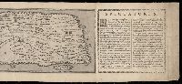
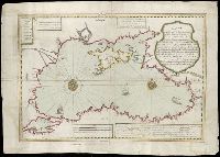
Dukedom and electorat of Brandenbourg, which is a part of the circle of the higher Saxony divided into its principall marches ... described by Sanson, corrected & amended by William Berry
Description:
BEIN 1973 Folio 10: Sheet measures 61.1 x 86.4 cm. Bookplate of José M. Rodriguez. No. 35 of 63 maps bound together., Relief shown pictorially., Ferro meridian., Dedicated "To the most serene and most sacred maty. Charles II ..." by William Berry., and Bar scales in Italian miles, common leagues of Germany, great leagues of Germany, and common leagues of France.
Publisher:
Sold by William Berry at the sign of the Globe between Charing-Cross, and White-Hall
Manuscript on parchment of an outline map of Europe, Africa, Asia, the surrounding seas and the islands including Iceland, Greenland, and "Vinland," which resembles the coastline of northern North America, with identifying legends. Known as the "Vinland Map," at the time it was acquired by Yale it was considered to be the earliest European map of any portion of the Western Hemisphere. The authenticity of the map was the subject of considerable debate for decades. Extensive scientific testing sponsored by Yale University in 2021, conclusively demonstrated that the map is a modern forgery and Originally the Vinland Map, Speculum historiale (Beinecke MS 350), and Hystoria Tartarorum (Beinecke MS 350A.1) were bound together in that order in a single volume, as is indicated by the patterns of the wormholes