Search
You Searched For
Search Results
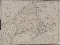
- Creator:
- Jefferys, Thomas, -1771
- Published / Created:
- 15 June 1775.
- Call Number:
- 732 1775
- Container / Volume:
- BRBL_00727
- Image Count:
- 1
- Resource Type:
- Maps, Atlases & Globes
- Found in:
- Beinecke Rare Book and Manuscript Library > A new map of Nova Scotia, and Cape Breton Island : with the adjacent parts of New England and Canada, composed from a great number of actual surveys; and other materials regulated by many new astronomical observations of the longitude as well as latitude
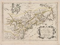
- Creator:
- Lodge, John, -1796
- Published / Created:
- 31st July 1785.
- Call Number:
- 732 1785
- Container / Volume:
- BRBL_00376A
- Image Count:
- 1
- Resource Type:
- Maps, Atlases & Globes
- Found in:
- Beinecke Rare Book and Manuscript Library > A new map of Nova Scotia, and Cape Britain [cartographic material] : With the adjacent parts of New England and Canada, from the latest authorities / J. Lodge sc.
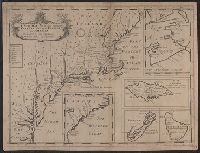
- Creator:
- Wells, Edward, 1667-1727
- Published / Created:
- 1722?]
- Call Number:
- 755 1722
- Container / Volume:
- BRBL_00425
- Image Count:
- 1
- Resource Type:
- Maps, Atlases & Globes
- Found in:
- Beinecke Rare Book and Manuscript Library > A new map of the most considerable plantations of the English in America : dedicated to His Highness William Duke of Glocester / Sutton Nichols sculp.
- Published / Created:
- [1755?]
- Call Number:
- 71 1755G
- Container / Volume:
- BRBL_00363
- Image Count:
- 1
- Resource Type:
- Maps, Atlases & Globes
- Found in:
- Beinecke Rare Book and Manuscript Library > Carta d'una parte dell' America Settentrionale : che serve per ben poter intendere le pretensioni delli Inglesi, esposte ne loro memoriali in occasione della regolazione de limiti con la Francia nell' America svdetta.
- Creator:
- France. Dépôt général de la marine
- Published / Created:
- 1779
- Call Number:
- 732cea 1779
- Container / Volume:
- BRBL_00377
- Image Count:
- 1
- Resource Type:
- Maps, Atlases & Globes
- Found in:
- Beinecke Rare Book and Manuscript Library > Carte reduite de l'Acadie ou Nouvelle Ecosse : comprenant une partie de l'Isle Royale, de l'Isle St. Jean et du Canada / dressée au Dépôt Général des Cartes, Plans et Journaux de la Marine, pour le service des vaisseaux du Roi, par ordre de M. de Sar
- Creator:
- Chabert, Joseph Bernard, marquis de, 1724-1805
- Published / Created:
- 1751?]
- Call Number:
- 732cea 1751
- Container / Volume:
- BRBL_00377
- Image Count:
- 1
- Resource Type:
- Maps, Atlases & Globes
- Found in:
- Beinecke Rare Book and Manuscript Library > Carte réduite des côtes de l'Acadie, de l'Isle Royale, et de la partie méridionale de l'Isle de Terre-Neuve : dressée sur les observations faites par ordre du Roi en 1750 et 1751 / par Mr. le Marquis de Chabert, capitaine des vaisseaux de S.M. de l'Ac
- Creator:
- Sanson, Nicolas, 1600-1667
- Published / Created:
- 1657
- Call Number:
- 73 1657
- Container / Volume:
- BRBL_00680
- Image Count:
- 1
- Resource Type:
- Maps, Atlases & Globes
- Found in:
- Beinecke Rare Book and Manuscript Library > Le Canada, ou, Nouvelle France, & c : tirée de diverses Relations des François, Anglois, Hollandois, &c. / par N. Sanson d'Abbeville.
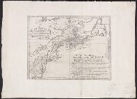
- Creator:
- Turner, James, d. 1759
- Published / Created:
- [1776]
- Call Number:
- 732 1776
- Container / Volume:
- BRBL_00376A
- Image Count:
- 1
- Resource Type:
- Maps, Atlases & Globes
- Found in:
- Beinecke Rare Book and Manuscript Library > This map of the province of Nova-Scotia and parts adjacent.