Carte de l'Italie et de touts ses routes de poste, à l'usage de voyageurs
Description:
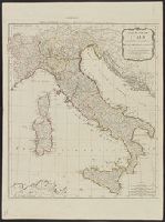
Appears in Laurie and Whittle, A new universal atlas, 1796, plate 16., Horizontal fold at middle of map and guard on verso., Includ, Relief shown pictorially., and Sheet measures 72 x 54 cm. Stamp on verso: Karpinski-von Wieser Map Collection. dgvmp2008.
Publisher:
Laurie & Whittle,
Subject (Geographic):
Italy--Maps--Early works to 1800
Subject (Name):
Anville, Jean Baptiste Bourguignon d', 1697-1782 and Robert Laurie and James Whittle
"This map is copied from an original drawn by Monsr. D'Anv, Also appeared in Kitchin's General atlas describing the whole universe. London : Printed for Robert Sayer, [1780]., Prime meridians: Ferro and London., and Relief shown pictorially; depths by soundings.
Publisher:
Printed for Robert Sayer,
Subject (Geographic):
Africa, West--Maps--Early works to 1800
Subject (Name):
Abbot, Charles,--Baron Colchester,--1757-1829--Bookplate, Anville, Jean Baptiste Bourguignon d', 1697-1782, Kitchin, Thomas, d. 1784. General atlas describing the whole universe, and Robert Laurie and James Whittle