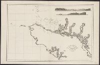
Vista de la entrada de Nutka, demorando la Pta. A. al N. 27⁰ E. del mundo distancia 21 millas. and Vista del Cabo Frondoso, demorando el Yslote A al N. 37⁰ O. distancia 12 1/2 millas, B. Cabo Frondoso.
Description:
Includes inset of "Vista de la entrada de Nutka, demorando la Pta. A. al N. 27⁰ E. del mundo distancia 21 millas ... " and "Vista del Cabo Frondoso, demorando el Yslote A al N. 37⁰ O. distancia 12 1/2 millas, B. Cabo Frondoso.", Relief shown pictorially., and S
Publisher:
s.n.,
Subject (Geographic):
Pacific Coast (B.C.)--Maps--Early works to 1800 and Vancouver Island (B.C.)--Maps--Early works to 1800
Subject (Name):
Alcalá-Galiano, Dionisio, 1760-1805, Arnold, Robert M.--Ownership, Ballester, Joaquin, Spain. Dirección de Hidrografía. Atlas marítimo español, and Valdés Flores Bazán y Peón, Cayetano, 1767-1835
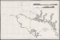
Vista de la entrada de Nutka, demorando la Pta. A. al N. 27⁰ E. del mundo distancia 21 millas. and Vista del Cabo Frondoso, demorando el Yslote A al N. 37⁰ O. distancia 12 1/2 millas, B. Cabo Frondoso.
Description:
Includes inset of "Vista de la entrada de Nutka, demorando la Pta. A. al N. 27⁰ E. del mundo distancia 21 millas ... " and "Vista del Cabo Frondoso, demorando el Yslote A al N. 37⁰ O. distancia 12 1/2 millas, B. Cabo Frondoso.", Relief shown pictorially., and W
Publisher:
s.n.,
Subject (Geographic):
Pacific Coast (B.C.)--Maps--Early works to 1800 and Vancouver Island (B.C.)--Maps--Early works to 1800
Subject (Name):
Alcalá-Galiano, Dionisio, 1760-1805, Arnold, Robert M.--Ownership, Ballester, Joaquin, Spain. Dirección de Hidrografía. Atlas marítimo español, and Valdés Flores Bazán y Peón, Cayetano, 1767-1835
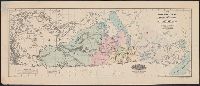
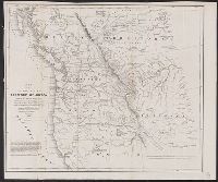
Abert, John James, 1788-1863, Arnold, Robert M.--Ownership, Hudson's Bay Company, Hudson's Bay Company--Maps, Stansbury, M. H, Stenzel, Franz--Ownership, and Stenzel, Kathryn M.--(Kathryn Mathi
From the collection of Robert M. Arnold., Includes text., and Relief shown by hachures.
Publisher:
U.S. Senate,
Subject (Geographic):
Northwest, Pacific--Maps
Subject (Name):
Abert, John James, 1788-1863, Arnold, Robert M.--Ownership, Hudson's Bay Company, Hudson's Bay Company--Maps, Stansbury, M. H, Stenzel, Franz--Ownership, and Stenzel, Kathryn M.--(Kathryn Mathi
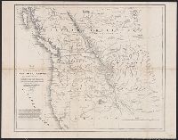
Includes text., Mounted on linen., and Relief shown by hachures.
Publisher:
U.S. Senate,
Subject (Geographic):
Northwest, Pacific--Maps
Subject (Name):
Abert, John James, 1788-1863, Arnold, Robert M.--Ownership, Hudson's Bay Company, Hudson's Bay Company--Maps, Stansbury, M. H, Stenzel, Franz--Ownership, and Stenzel, Kathryn M.--(Kathryn Mathi
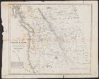
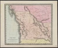
"48" at lower right corner in margin., "Entered according to act of Congress in the year 1836 by Illman & Pilbrow in the Clerk's office of the District Court for the Southern District of New-York.", Appears in Burr's A new universal atlas. 1835., and Prime meridians: Washington and Greenwich.
Publisher:
Illman & Pilbrow,
Subject (Geographic):
Canada, Western--Maps and Northwest, Pacific--Maps
Subject (Name):
Arnold, Robert M.--Ownership and Burr, David H., 1803-1875. New universal atlas. 1835
Subject (Topic):
Indians of North America--Canada, Western--Maps and Indians of North America--Northwest, Pacific--Maps
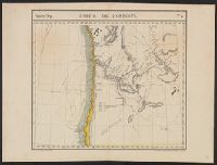
Appears in the author's Atlas universel de géographie physique, politique, statistique et minéralogique. 1827., In top margin: Amer. sep. ... no 38., and Relief shown by hachures.
Publisher:
P. Vandermaelen,
Subject (Geographic):
Oregon--Maps, Pacific Coast (Or.)--Maps, Pacific Coast (Wash.)--Maps, and Washington (State)--Maps
Subject (Name):
Arnold, Robert M.--Ownership and Vandermaelen, Philippe, 1795-1869. Atlas universel de géographie physique, politique, statistique et minéralogique
Appears in the author's Atlas universel de géographie physique, politique, statistique et minéralogique. 1827., In top margin: Amér. sep. ... no 31., and Relief shown pictorially.
Publisher:
P. Vandermaelen,
Subject (Geographic):
British Columbia--Maps, Pacific Coast (B.C.)--Maps, Pacific Coast (Wash.)--Maps, and Washington (State)--Maps
Subject (Name):
Arnold, Robert M.--Ownership and Vandermaelen, Philippe, 1795-1869. Atlas universel de géographie physique, politique, statistique et minéralogique