According to Sellers and Van Ee, this map is the 2nd state., At lower margin "London, printed for R. Sayer & J. Bennett, map & sea chartseller, no. 53, Fleet Street, as the act directs, Augst. 17th 1776., Includes a list of British colonies and territories., and Relief shown pictorially.
Publisher:
[Printed and sold by R. Sayer and J. Bennett, map and print seller, no. 53, Fleet St. 1776]
Subject (Geographic):
North America--Maps--Early works to 1800
Subject (Name):
Carver, Jonathan, 1710-1780, Jefferys, Thomas, d. 1771. American atlas, and Robert Sayer and John Bennett (Firm)
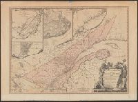
Includes insets of "A particular survey of the Isles of Montreal" and "Course of the river St. Laurence, from La Valterie to Quebec," and indexed insets of "The city of Quebec" and "Plan of Montreal, or Víllemarie.", Relief shown pictorially., and Stamp of Wil
Publisher:
Printed for Robert Sayer, no. 53 Fleet Street,
Subject (Geographic):
Québec (Province)--Maps--Early works to 1800
Subject (Name):
Carver, Jonathan, 1710-1780 and Morse, William Inglis,--b. 1874--Stamp