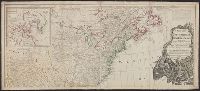
"Longit. west from Ferro I.", "Printed for John Bowles at the Black Horse in Cornhill & Carington Bowles in St. Pauls Church yard, London.", and Differs from other copy in coloration. Only boundaries are colored, emphasis is on showing the internal boundaries o
Publisher:
Printed for John Bowles,
Subject (Geographic):
NorthAmerica--Maps--Early works to
Subject (Name):
Bowles, Carington, 1724-1793, Bowles, John, 1701-1779, and Palairet, Jean, 1697-1774
"Longitude west from London.", First impression of 3d ed., Includes text and inset "A new map of Hudson's Bay and Labrador from the late surveys of those coasts.", and Relief shown pictorially.
Publisher:
Printed for Jefferys and Faden, geographers to the King,
Subject (Geographic):
NorthAmerica--Maps--Early works to
Subject (Name):
Jefferys and Faden, London and Kitchin, Thomas, d. 1784
Fourth ed., In bottom margin: Publish'd by the author Febry 13th 1755 according to act of Parliament., Includes text and inset "A new map of Hudson's Bay and Labrador from the late surveys of those coasts.", Relief shown pictorially., and Yale's copy stamped on b
Publisher:
Printed for Jefferys and Faden, geographers to the King,
Subject (Geographic):
NorthAmerica--Maps--Early works to
Subject (Name):
Jefferys and Faden, London and Kitchin, Thomas, d. 1784
"Sold by Wm. Herbert on London Bridge & Robt. Sayer over against Fetter Lane in Fleet Street.", Includes inset showing North America from Hudson's Bay to Panama., Library copy shows damage in top and bottom margins., and Relief shown pictorially.
Publisher:
Sold by Wm. Herbert ...,
Subject (Geographic):
NorthAmerica--Maps--Early works to
Subject (Name):
Sayer, Robert, 1725-1794 and Society of Anti-Gallicans
Includes historical notes, insets of "A particular map of Baffin and Hudson's Bay" and "The passage by land to California," and articles 4-7, 9, 12, 13, and 20 of the "definitive treaty.", Prime meridian: London and Ferro., Relief shown pictorially., and Stamped
Date in printer statement, in lower right margin: 15th July 1779., Includes notes and insets of "A particular map of Baffin and Hudson's Bay" and "The passage by land to California ....", Prime meridian: London and Ferro., and Relief shown pictorially.
Insets: A particular map of Baffin and Hudson's Bay -- The passage by land to California., Prime meridians: London and Ferro., Relief shown pictorially., and Yale's copy 1 joined on 2 sheets, 54 x 121 cm. and 54 x 120 cm.; coloring differs from copy 2; and stamp
Publisher:
Published by Laurie & Whittle, No. 53 Fleet Street,
Includes historical notes, text, and insets "A particular map of Baffin and Hudson's Bay" and "The passage by land to California, discover'd by Father Eusebius Francis Kino, a Jesuit; between the years 1698 and 1701, before which, and for a considerable t
Publisher:
Printed for Robt. Sayer, map, chart & printseller,
From George Henry Millar's New complete & universal system of geography. 1782., Inset map: "East Florida continued"., Recto: Numbered "166" (?) in ink ms. Verso: Stamped "Yale Horace Brown 1900S"., and Relief shown pictorially.
Publisher:
Engrav'd for Millar's New complete & universal system of geography,