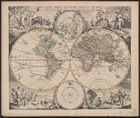
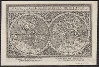
"L'ontrouve sur les paralleles ou degrés de latitude de cette carte les heures des jours selon le signe où se trouve le soleil, la difference des ombres, par le moïen des quelles feu Mr. d'Estoubeuille pretendoit demonstrer les longitudes." and Has waterma
Publisher:
[s.n.],
Subject (Geographic):
World--Maps--Early works to 1800
Subject (Topic):
Longitude--Measurement--Maps--Early works to 1800 and World maps--Early works to 1800
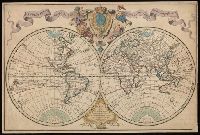
New and correct sea chart of the whole world shewing the variations of the compass as they were found in the year MDCC and Nova et accuratissima totius terrarum orbis tabula nautica, variationum magneticarum index juxta observationes anno. 1700
Description:
Text at bottom: "Sold by R. & W. Mount and T. Page in Postern Row, Tower Hill".
Allegorical vignettes of the four seasons., Cf. Shirley, R. Mapping of the world, no. 545., Cross Collection no. 25., and Double hemisphere, with smaller polar insets.
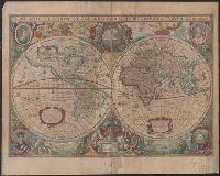
Blaeu, Willem Janszoon, 1571-1638 Blaeu, Willem Janszoon, 1571-1638. Theatrum orbis terrarum. French Ende, Josua van den, ca. 1584-ca. 1634 Hooft, Cornelis Pieterszoon, 1547-1626
Published / Created:
[between 1635 and 1650]
Call Number:
11 1635
Container / Volume:
BRBL_00003
Image Count:
2
Resource Type:
Maps, Atlases & Globes
Description:
Appears in the author's Theatrum orbis terrarum. 1635., Dedicated to "Cornelio Petri fan Hooft.", Described in: The mapping of the world / Rodney W. Shirley. London : Holland Press, 1983. No. 255, state 4., Includes insets of the po, and Relief shown pictorially.
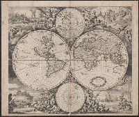
Nova totivs terrarvm orbis geographica ac hydrographica tabvla
Description:
Appears in Jan Jansson's Appendix novi Atlantis (1637) and Jan Jansson and Hendrik Hondius's Atlas novus (1638)., Double hemisphere on sheet, with portraits of Ptolemy, J. Hondius, Caesar and Mercator., Relief shown pictorially., and With dedication to David Sanclarus, Antonius de Willon and Martinius by Hendrik Hondius, dated 1630.
Imperfect: mutilated along folds, with some loss of text. Cross collection no. 24., Includes ill. and ancillary maps of north and south polar regions., and Relief shown pictorially.